Tag: Nafford Lock

  • River Avon Loop via Nafford

    River Avon Loop via Nafford

    A good book has captured Lynnie’s attention so Crosby and I are venturing out on our own today.   It is an essential part of our packing to ensure the caravan contains a sufficient number of books to open a small library.  Both of us have a bit of a book habit and can’t be trusted to walk out of a charity shop without having acquired more reading material.  The idea of an undisturbed day to read is, therefore, ideal as far as Lynnie is concerned.

    I am walking from the site with a rough idea of a circuit but no clear route planned.  I refer to days like this as “jamming about”, I just go where the mood takes me.  As long as I’ve a flask of tea and some lunch there is no need for a strict route.

    Leaving the site by the pedestrian access I walk down to the road and then turn left heading uphill into Pensham Hill and continue until I reach a road junction where I turn left and follow the lane out of the village on the route of the Shakespeare’s Avon Way.  

    Soon the lane turns into a farm track and the route continues between fields with the snow covered Bredon Hill in front of me.

    After passing junctions with two other paths the map shows the footpath going diagonally across a field, however it is clear the route around the edge of the field is well walked so rather than damage crops I follow the field margin to reach a footbridge over a stream.

    The path now goes to the right and then left around the edge of a recently ploughed field and then turns to the right to walk a grassy path besides the site of a former golf course currently being turned into a mobile home park.

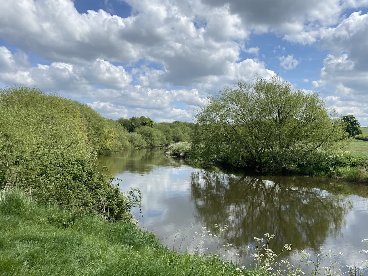
    After going through a kissing gate the path descends to the River Avon where I turn left and head along a broad grassy path besides the river.

    After going through another gate the footpath turns away from the river and heads up a lane towards Great Comberton.  At a junction with a road I turn right to walk into the village and then fork right by a telephone box to continue through this attractive village.

    At a way-marker for a footpath to Nafford I turn right following the path to a wooden gate which I go through and continue downhill.

    I am still on the route of the Shakespeare’s Avon Way, this is an eighty-eight mile long distance trail following the River Avon from its source at Nasby in Northamptonshire to Tewkesbury in Gloucestershire.

    At the foot of the hill I go through another gate and then follow the path as it turns to the right and heads through a field of sheep pasture.

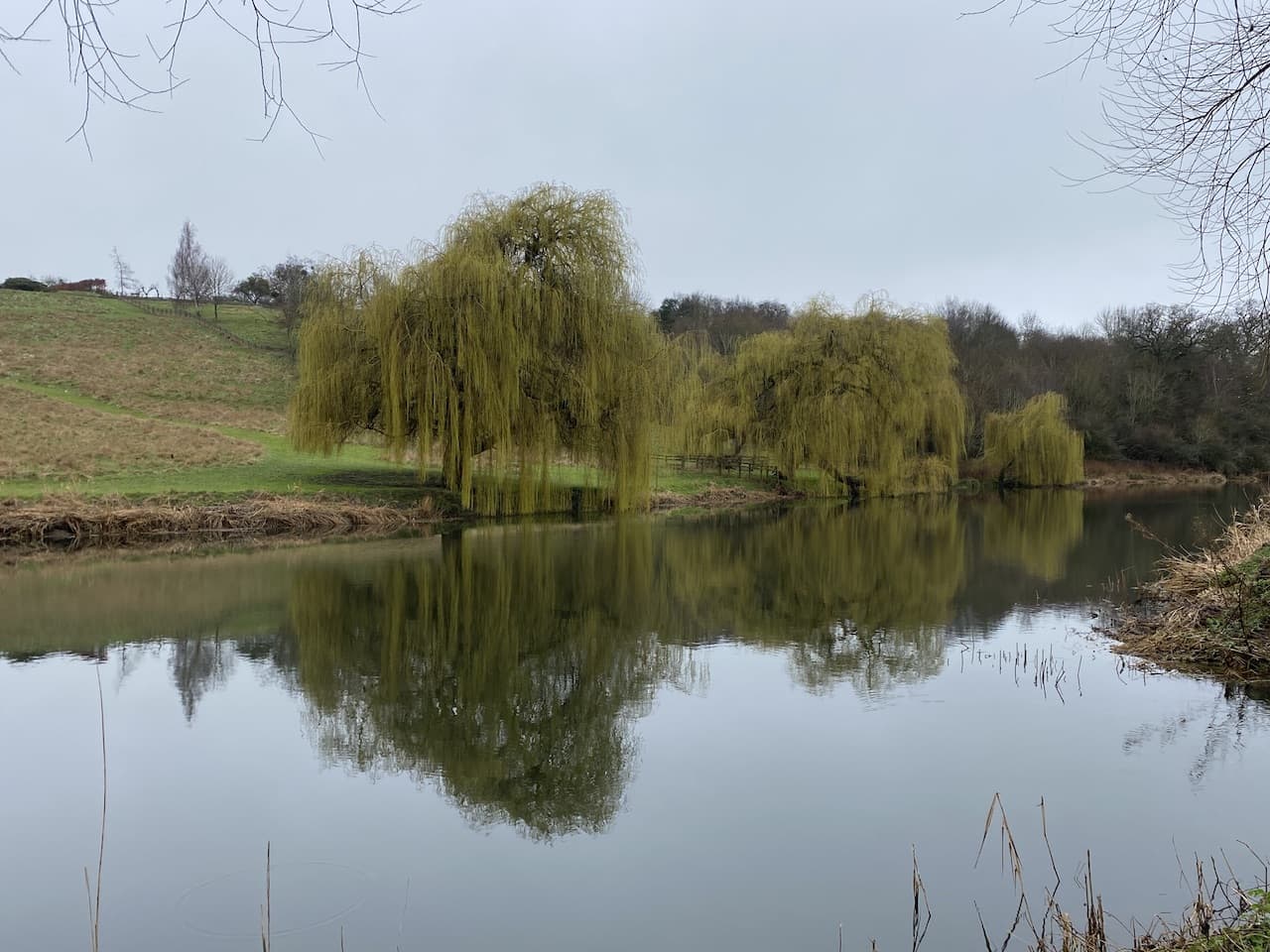
    After another gate into a field I get fine views over the River Avon.

    Keeping the fence line close to my left I continue through the field and then descend to reach a footbridge over a stream.  Over the bridge I cross a field to a gate and another field.  The path heads towards Nafford House and then after going through a kissing gate reaches a minor road.

    I keep straight on to pass Nafford House and then take a footpath on the right heading downhill to reach the River Avon at the sluice gates.

    Crossing the sluice gates I reach Nafford Lock which makes the River Avon navigable at this point.  According to the Avon Navigation Trust’s website it was back in 1636 when William Sandys of Fladbury came up with a plan to make the river navigable from Tewkesbury to Stratford.  In the 1830’s the Worcester and Birmingham Canal company leased the river, but like many canal companies suffered from increased competition from railways.

    By World War II the route was barely navigable but in 1950 restoration commenced and by 1962 the Lower Avon Navigation was reopened to Evesham and then in 1974 it reopened  all the way to Stratford.

    Crossing on a swing bridge I continue to the weir over the Avon.

    After crossing the weir I had intended to turn left and follow the footpath towards Birlingham, however, I spot a permissive path way-marker and follow this to the right heading towards the river.  The permissive path then enters a field beside the river.

    This path is not marked on the map so I am unsure where it will lead me. But then as luck would have it I meet a chap walking in the opposite direction who explains that the path follows the river for a few miles and then heads back to Birlingham via Woodfield Farm.  Comfortable in this knowledge I continue along the path.

    This is pleasant walking with nobody else about as I follow the frequent way-markers.

    The river is very tranquil and there are cracking views of it as the path heads north.

    After crossing a footbridge over a stream, with a plaque saying it’s “Baker’s Bridge” I decide to stop for lunch in a spinney which has a great outlook over the river.

    I am soon heading along the river on the opposite side of the bank from where I was walking earlier as I headed to Great Comberton.

    The land in this area is mainly used for growing vegetables and there are extensive irrigation systems which use water pumped from the river.  To facilitate the extraction of the water, pump houses sit close to the river.

    I stay with the river until reaching a fence into a field, here the permissive path goes left towards Woodfield Farm which has a number of static caravans, presumably used by agricultural workers.

    After passing the farm I reach a road where I turn right and walk along it heading west.  I ignore a minor road on the left and carry on to a T-junction turning right and then almost immediately take a footpath on the left, initially through trees, to reach an open area and then continue through a field.

    The path joins a driveway passing properties and then continues along a track.

    Near the end of the track I take a footpath on the right way-marked to Upper End.

    This path leads along the hedge line of a field to reach a minor road where I cross and continue on the hedge-lined footpath besides a property.  At a kissing gate the path enters an old orchard, Rough Hill Orchard, and turns left with good views across to the River Avon.

    Rough Hill Orchard is owned by the People’s Trust for Endangered Species and contains 30 old apple trees, 65 young apple trees and 25 plum trees.  Apparently on this site nineteen nationally scarce species insects have been recorded.

    Initiatives like this are great for the environment and educating people on the importance of maintaining habitats for flora and fauna.

    The path leads to an information board beside a gate.  Here I leave the orchard and cross the busy A4104 with care and follow a path into Tiddesley Wood.  

    This area of woodland was once an enclosed deer park owned by the Abbots of Pershore Abbey. In the 1950’s the Forestry Commission took ownership and planted coniferous trees making it a commercial woodland.  Now in the ownership of the Worcestershire Wildlife Trust they are in the process of clearing the remaining coniferous trees and replacing them with traditional deciduous woodland.

    The path leads through the trees to reach a track where I turn right and head down to reach the A4104 again.  I cross and take a way-marked footpath on the far side turning left to walk along the grassy verge to reach a kissing gate leading into a field where I head towards the River Avon.

    At the river I turn left and follow a path beside it heading back towards Pershore.

    It has started to rain, but luckily I don’t have far to go.  After walking besides fields the path goes along the edge of a copse and then reaches open land.  I keep by the river and climb steps at the end of Pershore Bridge to the road where I turn right across the bridge.

    At a road junction I turn right and walk the short distance back to the pedestrian entrance to the caravan site.  

    You can view this  9.5 mile walk on OS Maps and download the GPX File Here

    To follow this walk, you will need Ordnance Survey Explorer Map – 190 – Malvern Hills & Bredon Hill

    9th March 2023

    © Two Dogs and an Awning (2023)

    All information on this site is provided free of charge and in good faith and no liability is accepted in respect of damage, loss or injury which might result from it.  To the best of my knowledge the routes are entirely on public rights of way or within areas that are open for public access.
    Walking can be hazardous and is done entirely at your own risk.  It is your responsibility to check your route and navigate using a map and compass.

  • Eckington Bridge and Nafford Lock

    Eckington Bridge and Nafford Lock

    Today we are walking from the caravan again, this time heading out over a route we did last November, but this time we are doing it the other way around with a couple of variations and an additional section alongside the River Avon.

    We leave the caravan site and follow the pavement towards Pershore.  Just after crossing the River Avon we turn left on a footpath joining the route of the Millennium Way, this 100-mile long distance path goes between Pershore and Middleton Cheney in Northamptonshire.  

    There are a network of tracks across the meadows but we stick with the Millennium Way which hugs the side of the river heading in a westerly direction.

    After passing besides a copse and crossing a bridge over a stream we ignore a footpath on the right, instead continuing beside the river.

    At the next junction of paths besides a footbridge over a stream, the Millennium Way turns to the right, we continue besides the river on the route of the Pershore Bridges Walk this is a five-mile circular walk around Pershore.

    After crossing a couple of footbridges the waymarked path turns to the right to head towards houses sat above the A4104.

    After going through a kissing gate we turn left and walk on the wide roadside verge and then cross with care at a waymarker  to head into Tiddesley Wood.

    We follow the Pershore Bridges Walk waymarkers through the woods.  This area of woodland was once an enclosed deer park owned by the Abbots of Pershore Abbey. In the 1950’s the Forestry Commission took ownership and used it a as commercial woodland and planted coniferous trees.  Now in the ownership of the Worcestershire Wildlife Trust there is a process of clearing the remaining coniferous trees and replacing them with traditional deciduous woodland.

    The route is a clear track and easy to follow.  Reaching a crossing of way-marked footpaths we turn left leaving the route of the Pershore Bridges Walk and rejoining the Millennium Way which heads steadily downhill on a wide ride leading to a bridge over Bow Brook.

    After crossing the bridge at a fork in the path we leave the Millennium Way and take a path on the left which heads diagonally across a field.

    The map shows the path leaving the field and entering an area of shrubland.  In November we walked though that shrub area and there was no clear path, I had hoped that it might have been cleared but sadly it is still overgrown and unclear, so we continue along the edge of the field to reach a gateway where we turn left along a minor road and then after just over a hundred yards we take a footpath on the right.  The fingerpost here appears to have been a casualty to hedge cutting.

    The footpath follows a track between arable fields heading towards Besford Court.  At a junction of paths we carry straight on into the grounds of Besford Court.  The original timber framed building was constructed here around 1500.  In 1910 the estate was purchased by Major George Noble who went about reconstructing the building into its current mode under the guidance of architect Albert Randall Wells.

    Apparently work stopped in 1912 when the Noble’s separated and they were divorced in 1916.  The following year Noble’s wife married his architect.  The house was never completed or lived in and was sold in its incomplete state and became known as Besford Court Hospital and it was apparently described in the New Catholic Dictionary as a “welfare home for mentally-defective Catholic children, restricted to feeble minded boys aged from seven to twenty-one”.

    In 2001 the school closed and even twenty-years later men are coming forward to describe the abuse they suffered at the hands of those entrusted with their welfare.  Following the closure of the school the building was converted into apartments.

    We follow the footpath waymarkers which pass a fine arch and then at a junction of paths turn right to walk with a hedge on our right and soon pass a football pitch on our left.

    After a stile we cross a minor road and go through a kissing gate into a field.  There are a network of paths crossing this field.  It has recently been sown and the pathways are not clear but we opt for one in a south-westerly direction diagonally across the field towards a property in the village of Besford.

    After crossing a stile we continue along the side of a paddock and then cross a wooden fence and then immediately go through a gate.  It is unclear what purpose the fence serves other than to make it more difficult for walkers to get through.

    On the road, cussing about inconsiderate landowners, we turn left and reach St Peter’s Church.  This 14th century church is apparently unique as it has the only timber nave in England.  The chancel was rebuilt in stone in the 19th century.

    According to the village’s website the interior of the church has important monuments, a pre-reformation rood screen and Jacobean alter rails.  Unfortunately the door is locked so we cannot go in to view them.  I find it hard to understand the policy of some diocese, you would think that people might want to gain access to a church outside of the times it’s open for services.

    We go back to the road and turn right and then almost immediately take a waymarked footpath down a track leading to a property.  As the track reaches the house the footpath turns right and goes through a gate the path now forks and we keep to the left to follow the fence line of the property and then enter another field where we go right keeping the hedge on our right and then at the corner of the field go left, still with the fence on our right.

    At the next the point when the fence turns to the right we head diagonally downhill across the field towards a gate.  After passing through the gate we turn left along a minor road and walk towards houses.  After about four hundred yards, on reaching houses on the left we take a footpath on the right which goes besides fields and heads towards Defford.  There are good views across the fields towards the Malvern Hills.

    After passing a playing field we go through a gate and reach Defford.  Now we go along the road towards St James Church which has Norman origins and underwent a major restoration in the 19th century.  This is another locked church so we have no idea what it might look like inside.

    Leaving the church we turn left and walk through the village.  On reaching a junction we turn right into Crown Lane and follow this to reach the A4104.  We cross the road and turn left in front of Defford Garage and then almost immediately take a footpath on the right which goes over a stile besides a gate.

    This path goes downhill by a field and then through a wooded area to reach a bridge over a stream. We then go uphill to reach a gate and pass through a field following the path down between hedges to reach a stile into a paddock.  Crossing the paddock, whilst trying to avoid the inquisitive horses, we reach another stile  onto a road.  We cross and enter open access land where we turn right and follow a well-worn path through the meadow towards Eckington Bridge.

    Apparently the first bridge constructed across the river here was built in 1440. The current red sandstone bridge dates back to the 1720’s.

    From the bridge we turn to the left and take a clear path that heads diagonally across the meadows in the direction of Birlingham.  To our right in the distance is the tower on Bredon Hill, a spot we visited last November.

    On the far side of the open access land we join the Shakespeare’s Avon Way, an eighty-eight mile long distance path following the river Avon from its source at Naseby to ins confluence with the River Severn at Tewkesbury.  We now follow this route around fields to reach a minor road where we turn right and then almost immediately take a left on a footpath through a wooden gate.  This path goes close to properties and then emerges on a road at a junction.  We head straight across and stay with the road as it turns into a track heading towards Nafford.

    We go through a kissing gate and then across Berwick Brook.

    The route continues to a weir on the River Avon.

    After crossing the weir we continue on the path to reach Nafford Lock which makes the River Avon navigable at this point.

    After crossing the lock we reach the sluice gates on the Avon.

    We now head uphill on a track to reach a minor road where we turn left.  As the road bends to the right we go through a kissing gate to follow a footpath across a field on the Shakespeare’s Avon Way.  There are great views across the river from here.

    After crossing a footbridge the path continues into the next field and passes a fine dead tree.

    At a gate we carry on through a further field, the route then goes to the left through a gate and heads uphill to reach another gate which leads to a road in Great Comberton.  Here we turn left and follow the road through this attractive village.

    We continue through the village and then take a footpath on the left shortly before reaching the village War Memorial.  This track leads steadily downhill back towards the River Avon where a couple of barges are moored and their occupants are enjoying the spring sunshine in a clearing.

    We now go to the right and pass through a gate to follow a broad grassy track with the river to our left.

    At a fork in the track just before reaching woodland we go right heading uphill on the route of the Shakespeare Avon Way.  This passes a field which looks as if it is being prepared as a static caravan park.

    After going through another gate we carry on following the path as it skirts the edge of a field and then crosses a footbridge.

    On the far side of the field the map shows the route going through the crops, however, it is clear that folk walk the perimeter of the field so we follow their example and turn right and then left around the field to join a track which leads towards Pensham Hill.

    The track soon becomes a tarmac lane leading into Pensham Hill where we turn right and follow the road to the private path leading back up to the caravan site at Goodleigh Hill CL.

    Our wander in this part of the Vale of Evesham has covered just over eleven and a half miles.  We are heading into Pershore to eat this evening so the timing is just right for us to get spruced up before we go.

    You can view this 11.5 mile walk on OS Maps and download the GPX File Here

    To follow my walk, you will need Ordnance Survey Maps: OS Explorer Map – 190 – Malvern Hills & Bredon Hill

    7th May 2022

    © Two Dogs and an Awning (2022)

    All information on this site is provided free of charge and in good faith and no liability is accepted in respect of damage, loss or injury which might result from it.  To the best of my knowledge the routes are entirely on public rights of way or within areas that are open for public access.
    Walking can be hazardous and is done entirely at your own risk.  It is your responsibility to check your route and navigate using a map and compass.