A few days ago the weather forecast for today was persistent rain from dawn to dusk, but yesterday evening it improved to show the rain moving through by early afternoon, so I spend the morning catching up with a few things in the caravan and then head out after an early lunch.
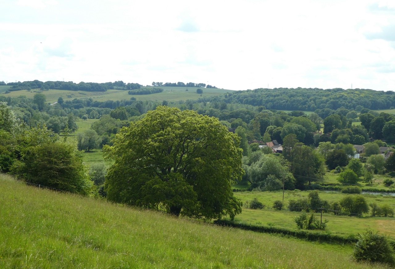
With a only a few hours of daylight I decide to head to Arundel Park and have a bit of a jamabout. The starting point for my walk is the roadside car park in Mill Lane near to the Wildlife and Wetland Trust entrance. From the car park I walk downhill and go through the gate to enter Arundel Park beside Swanbourne Lake.
This lake is thought to have originated in the 11th century as a mill pond created by damming the steam created from chalk springs. For centuries it served as the water supply to the mill and more recently has become a recreational area.
I follow the path beside the lake passing a few walkers who have braved the morning rain and are looking bedraggled. I reach a gate and go through.
I stay in bottom of the valley and at a junction of paths turn to the left and gradually ascend a track.
Heading uphill I am treated to fine views back over the route I have walked so far.
I go through a gate and then take some steps on the right onto open ground where I head across to the Hiorne Tower. This was built in 1797 by Francis Hiorne who at the time was bidding to rebuild Arundel Castle for the Duke of Norfolk.
In front of the tower is a relic found in a museum at Sevastopol after the siege of Sevastopol in 1855. This siege was part of the Crimean War and Russian soldiers withdrew into the port which was the home of the Tsar’s Black Sea Fleet. Here they became besieged by the French, Ottoman and British allied forces. The battle that ensued lasted from October 1854 to September 1855.
I now walk across to a tarmac drive and turn right to go through a gate and head north.
After going through a gate I continue on the tarmac driveway and pass through an area of woodland.
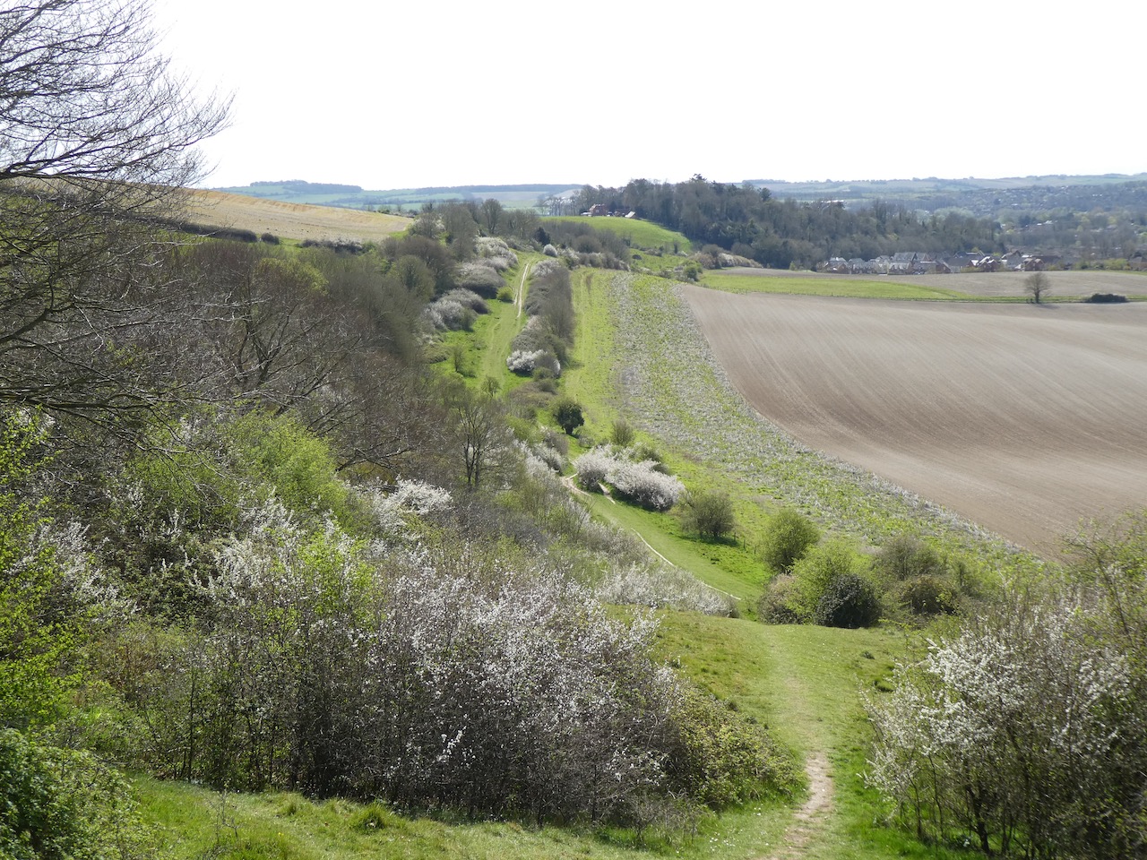
I had hoped to leave the park at Duchess Lodge but when I get there the gates are locked so I decide to keep heading north towards Whiteways Lodge. There are extensive views onto the South Downs and the flooded fields around Amberley.
Nearing a junction of tracks I meet a fellow walker heading in the opposite direction. I enquire if I will be able to exit the park at Whiteways Lodge and he thinks it unlikely, but then suggests a route I could follow that would take me back to Arundel via South Stoke.
Always willing to heed the advice of locals I turn right at the junction of tracks and head beside Lonebeech Plantation.
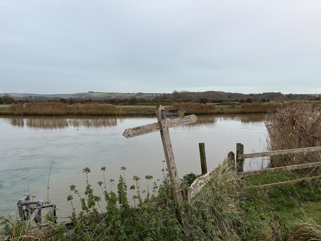
After going through a gate I head across a field towards a gate in the distance and midway turn left on a footpath which is the route of the Monarch’s Way and head towards a gate. This was the path I followed yesterday towards the River Arun. After going through a kissing gate I follow a track downhill with views towards Houghton and Amberley.
The way-marked route descends through the edge of South Wood to reach a metal gate in the wall of Arundel Park, I turn right beside the river. Yesterday my path alongside the river was low lying, today’s path quickly rises a few feet away from the water.
After going through an area of woodland I pass through a gate to continue along the edge of a field.
The footpath skirts around cattle barns and then passes a fine old barn apparently built in the late 1800’s and now used as a wedding and events venue.
After the barn I turn left at a junction and follow a lane passing cottages to reach St Leonard’s church. This old church was built in the 11th century and serves the small community around South Stoke Farm.
From the church I continue on a track heading towards the River Arun and just before reaching the river go over a stile on the right to join a footpath by the river.
The footpath follows the embankment with the river to my left and goes over several stiles heading towards Offham Farm.
At a track leading to Offham Farm I pass a bridge and continue along the embankment and then go through a copse to emerge into the car park of the Black Rabbit pub. Apparently the building dates to 1894 and was built by the Duke of Norfolk. It is an unusual name for a pub and after walking by it yesterday I did an unsuccessful search on the internet to see why it was given this name.
The pub has a beer garden with a fine views along the river. It must be very popular in the summer.
I have two options here I can either walk along the road to the car park or take the route alongside the river. The light is fading but I should have enough time to take the longer route by the river. I follow the footpath along the embankment to a junction of footpaths where I turn right back towards Arundel.
The path goes besides the stream flowing from Swanbourne Lake. Across the fields I get a good view of Arundel Castle. This castle was originally built in the 11th century, it was damaged during the English Civil War and then restored in the 18th and 19th century.
At a footbridge I turn right joining the road to walk back to my starting point. The route was not what I planned when I set off but nevertheless has been a cracking walk covering 7.5 miles.
All information on this site is provided free of charge and in good faith and no liability is accepted in respect of damage, loss or injury which might result from it. To the best of my knowledge the routes are entirely on public rights of way or within areas that are open for public access. Walking can be hazardous and is done entirely at your own risk. It is your responsibility to check your route and navigate using a map and compass.
With the weather looking set fair for the day I have decided to head out for a bit of a jamabout from Arundel. It is an area I have not previously walked, part of my route will be through Arundel Park where I gather there is permitted walking in some areas whilst others have no access, so I may have to adapt my walk as I go.
I start from the roadside parking area in Mill Road close to the entrance to Arundel Park and the Wildlife and Wetland Trust nature reserve. I head north up Mill Road and soon go by the entrance to the nature reserve and then pass the Black Rabbit Pub. Apparently this building dates to 1894 and was built by the Duke of Norfolk. It is an unusual name for a pub. Searching later I can’t find anything about the origins of the name.
The road passes through a cut in the chalk to reach a junction. Here I turn left towards South Stoke and continue up to the grand gates to Arundel Park.
Going through the gates I join a footpath following a track steadily uphill. It is a cracking day and after yesterday’s inclement weather it is refreshing to see clear blue sky.
As I head uphill there are fine views out to my right over the River Arun with some flooding in the fields. It is an ominous sign, I intend to follow a path close to the river later and hope it won’t be submerged.
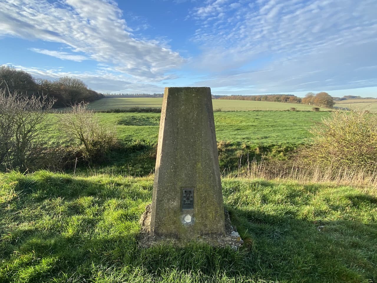
Nearing the top of the hill I fork to the left and wander over the open access land to bag the Drylodge Plantation Ordnance Survey trig pillar, my number 416 bagged.
Near the trig I meet a local couple out for a walk in Arundel Park, they share their ideas for some local walks and also helpfully advise me where I can walk in the Park. Following their advice I continue across the access land and go through a gate onto more access land with Drylodge Plantation to my left.
The path goes along the top of the hill with views across the South Downs to flooded fields around Houghton and Amberley.
After going through another gate I continue on the track towards Lonebeech Plantation and mid-way across the field turn right to join a footpath on the route of the Monarch’s Way. This leads to a gate.
The way-marked route goes downhill through the edge of South Wood to a metal gate in the wall of Arundel Park.
On the path besides the River Arun I turn left and head towards Houghton.
To my surprise I spot a seal in the river. Apparently they are a common sight in this river, but it was not what I was expecting.
Initially the path is dry, but as I near a disused chalk quarry it becomes flooded in parts and it takes careful navigation to avoid getting wet feet. To make matters worse there are a couple of fallen trees across the path which have not been cleared.
It is with some relief that I reach the edge of Houghton and go through a gate ascending from the river into Houghton. At a junction with the B2139 I turn left, still on the route of the Monarch’s Way and walk beside the busy road to pass the George and Dragon pub.
A notice above the pub door states Charles II stopped for refreshments on Tuesday 14th October 1651 whilst fleeing from his defeat at the Battle of Worcester.
Just after the pub the Monarch’s Way follows a bridleway that initially runs parallel to the road and then goes up onto downland with fine views. During the course of this year I have walked a number of sections of the 625-mile Monarch’s Way which roughly follows the route that Charles II took to get a boat at Shoreham after his defeat by Oliver Cromwell at Worcester.
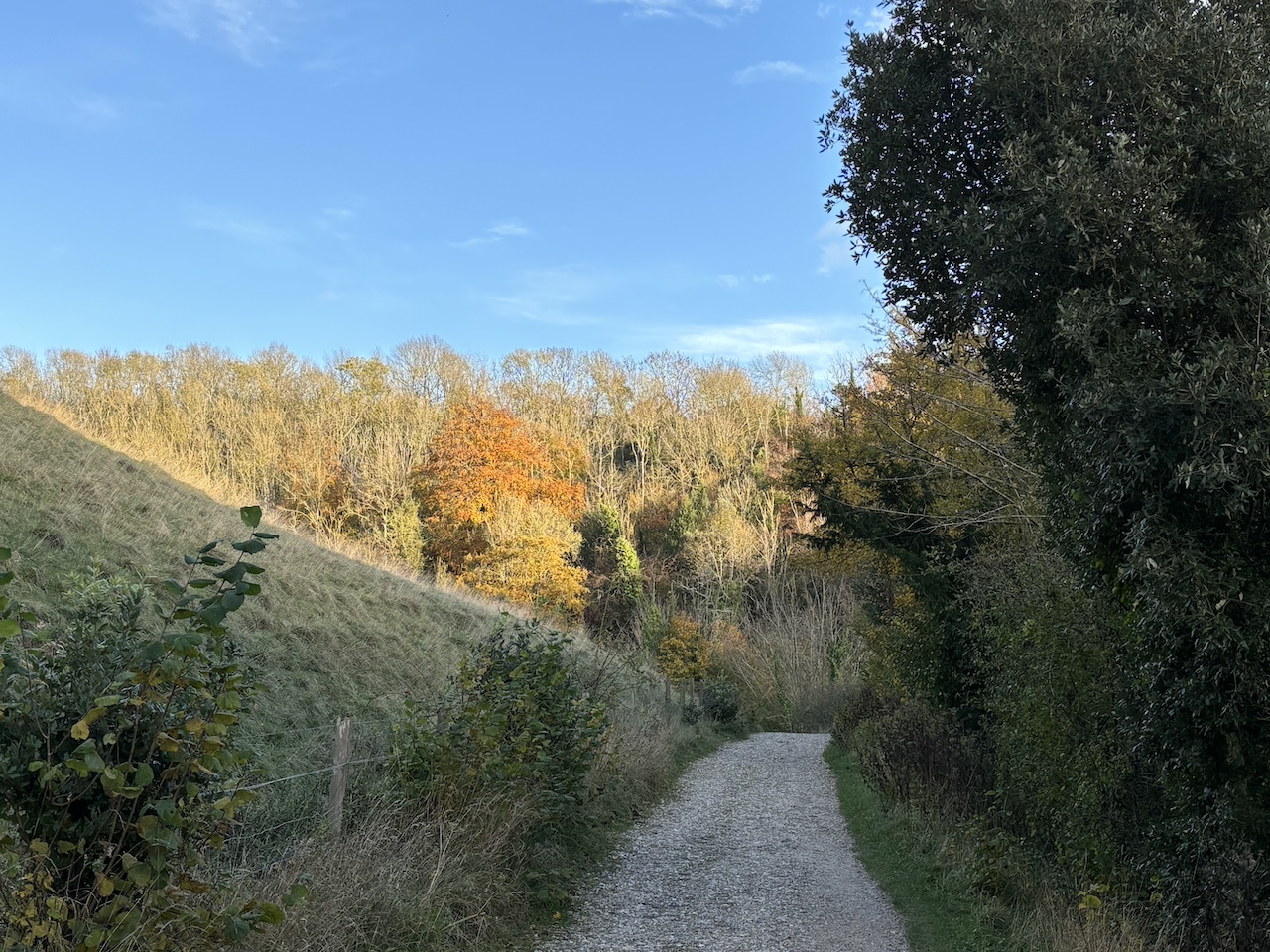
The route goes along the edge of fields and then through a sunken track before heading across another field to reach the A29. After crossing the road I keep following the Monarch’s Way way-markers into Houghton Forest.
This is a pleasant area of woodland. The only thing disturbing the tranquility is the distant sound of game birds being slaughtered.
Towards the western edge of the woods I reach a junction of paths and turn left heading south through the trees.
The path leads to a minor road which I cross and pass through a small parking area to enter another area of woodland. Staying with the clear path I head towards the A 29. Approaching the road the path forks, I go left soon emerging beside the main road. I cross with caution and on the far side ignore a footpath on my left instead taking a path going uphill through the open access woodland heading towards Yewtree Gate.
On reaching Yewtree Gate I turn left and enter Rewell Wood.
The track heads in a southeasterly direction passing areas of recently cleared and replanted trees and then goes alongside fields heading towards the A284.
At a junction of paths just before reaching the main road I turn right and follow a path downhill into woodland.
At Park Bottom Barn there is a junction of paths. I follow the one along a track leading to Cricket Hill Farm. There are no obvious signs of farming as I pass converted barns which are being used as offices and workshops.
The route is now straightforward, I pass a trout fishery and follow the farm driveway back towards Arundel. On reaching the A27 I turn left and then cross the A284 and walk into Arundel along Maltravers Street. At the junction with Parson’s Hill I turn left and walk up towards Arundel Cathedral.
At a junction with London Road I turn left and pass the catholic cathedral which was commissioned by the 15th Duke of Norfolk in 1868 and completed in 1873.
Walking besides the wall of Arundel Park I reach a driveway into the park on my right and follow it.
I keep with the tarmac driveway through the park and then before reaching a gate I take a footpath on the right which leads me to Hiorne Tower. This was built in 1797 by Francis Hiorne who at the time was bidding to rebuild Arundel Castle for the Duke of Norfolk.
In front of the tower is a relic found in a museum at Sevastopol after the siege of Sevastopol in 1855. This siege was part of the Crimean War and Russian soldiers withdrew into the port which was the home of the Tsar’s Black Sea Fleet and were then besieged by the French, Ottoman and British allied forces. The battle that ensued lasted from October 1854 to September 1855.
I am now back on the Monarch’s Way and follow this as it goes downhill with fine views across the park.
At the bottom of the hill I leave the Monarch’s Way at a junction of footpaths and turn right and walk through the valley towards Swanbourne Lake.
The path goes through a gate and continues on with the lake on my right hand side. This lake is thought to have originated in the 11th century as a mill pond created by damming the stream created from chalk springs. For centuries it served as the water supply to the mill and more recently has become a recreational area.
My wander about has covered twelve miles and it has been a cracking day. The forecast does not look great for tomorrow so I will have to hope for a break in the rain to head out for some fresh air.
All information on this site is provided free of charge and in good faith and no liability is accepted in respect of damage, loss or injury which might result from it. To the best of my knowledge the routes are entirely on public rights of way or within areas that are open for public access. Walking can be hazardous and is done entirely at your own risk. It is your responsibility to check your route and navigate using a map and compass.
Like so many people I find the winter months a gradual drain on my mood. In years gone by when I commuted to London for work we headed to Lanzarote for a couple of weeks winter sunshine to lift my spirits. It is over ten year since we did that and increasingly the lack of daylight and dull skies wear me down and I lose my bounce.
Spending time out walking helps lift my spirits, but during the winter there is always a spell when each walk is a trudge through the mud, or I am heading into driving rain. My mood is not helped by having Raynaud’s disease meaning that in colder weather my fingers and toes turn numb making even simple tasks very difficult.
Most of my winter walking is a solitary pastime. Lynnie is occasionally tempted to join me but apart from that and the odd day out with walking buddies I am on my own with Crosby. I like walking on my own, but there are times when the company of others perks up a walk.
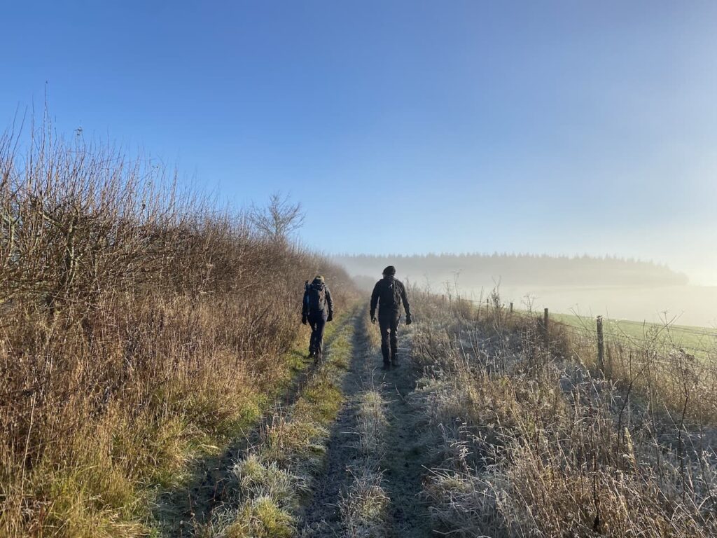
Today I am out with my walking buddies Mandy, Nigel and Gary. We are going to have a jamabout around Grovely Wood and as luck would have it we are forecast a bright day once the morning mist has lifted.
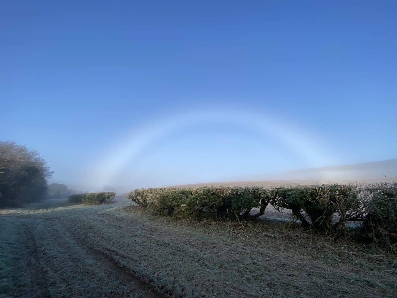
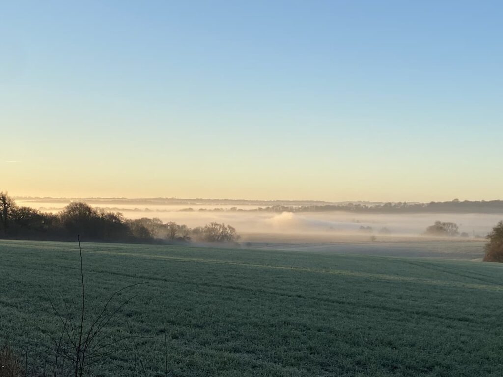
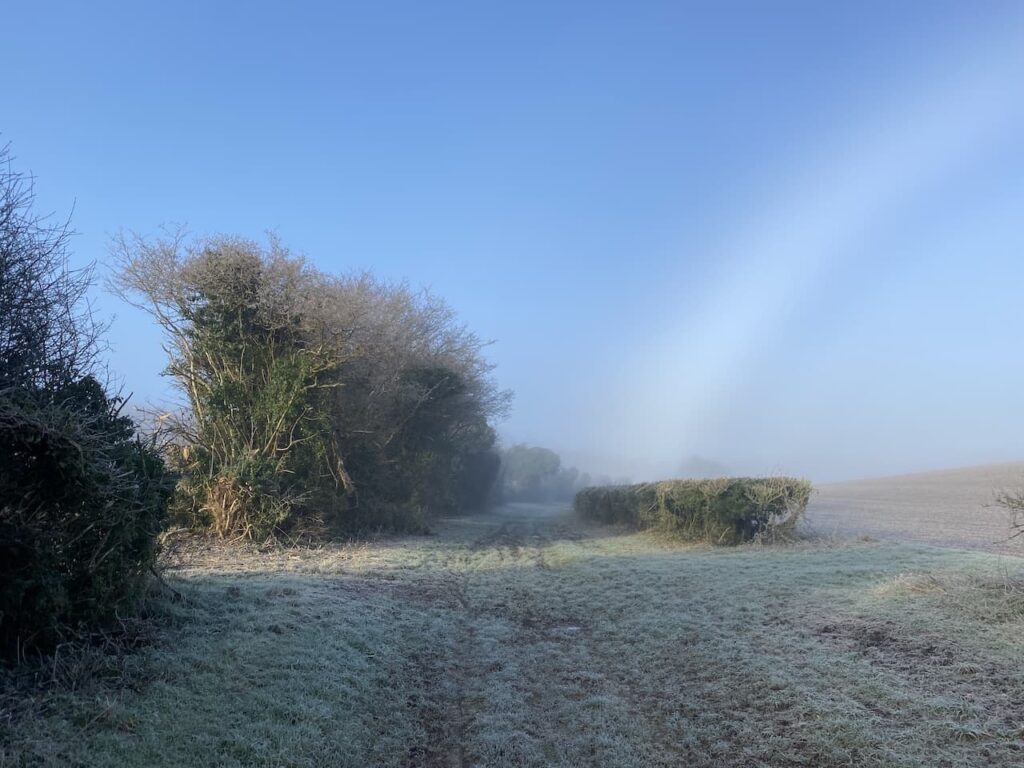
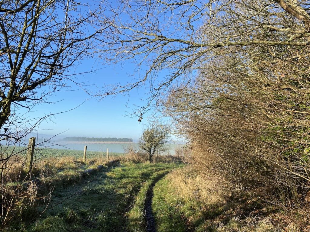
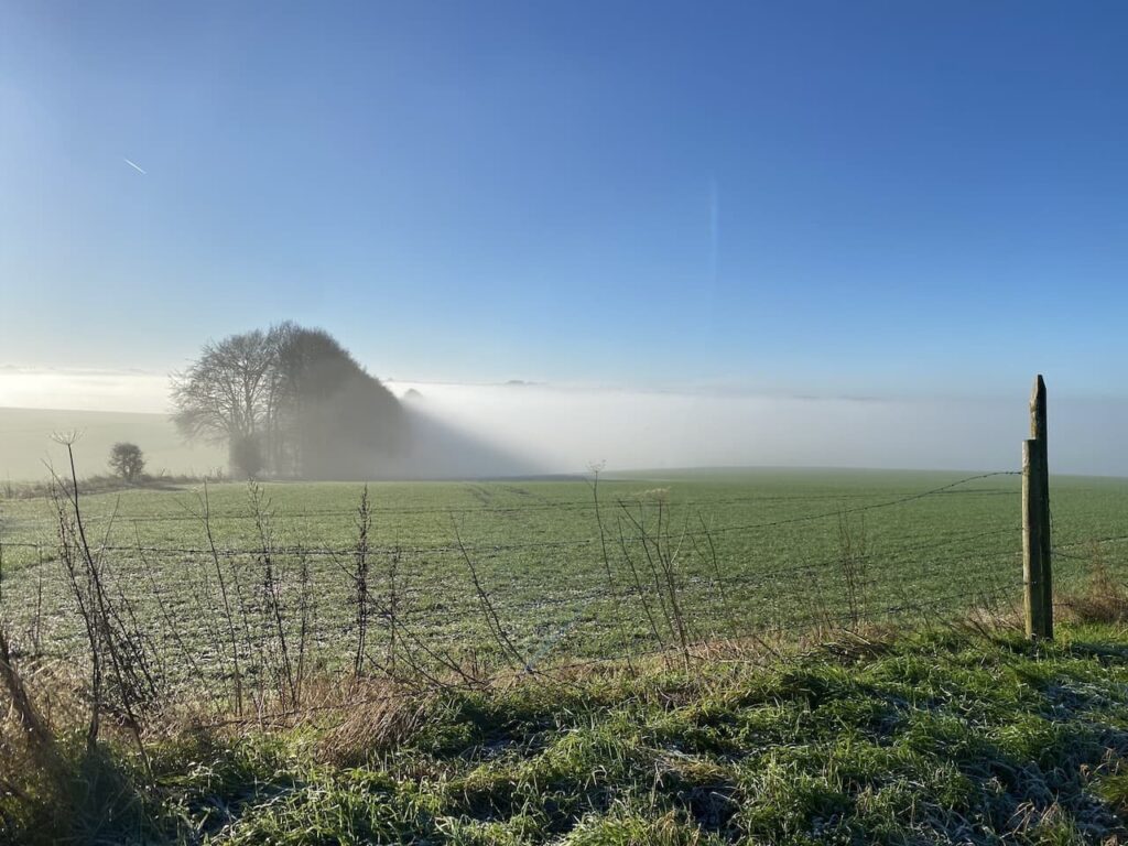
Our starting point is a parking area besides a drove at the west end of the woods (Grid Ref: SU007347). We set off along the drove heading in a south-easterly direction. It is a chilly start to the day but the sky is clear and we have a good view across the valley with the fog hanging below us.
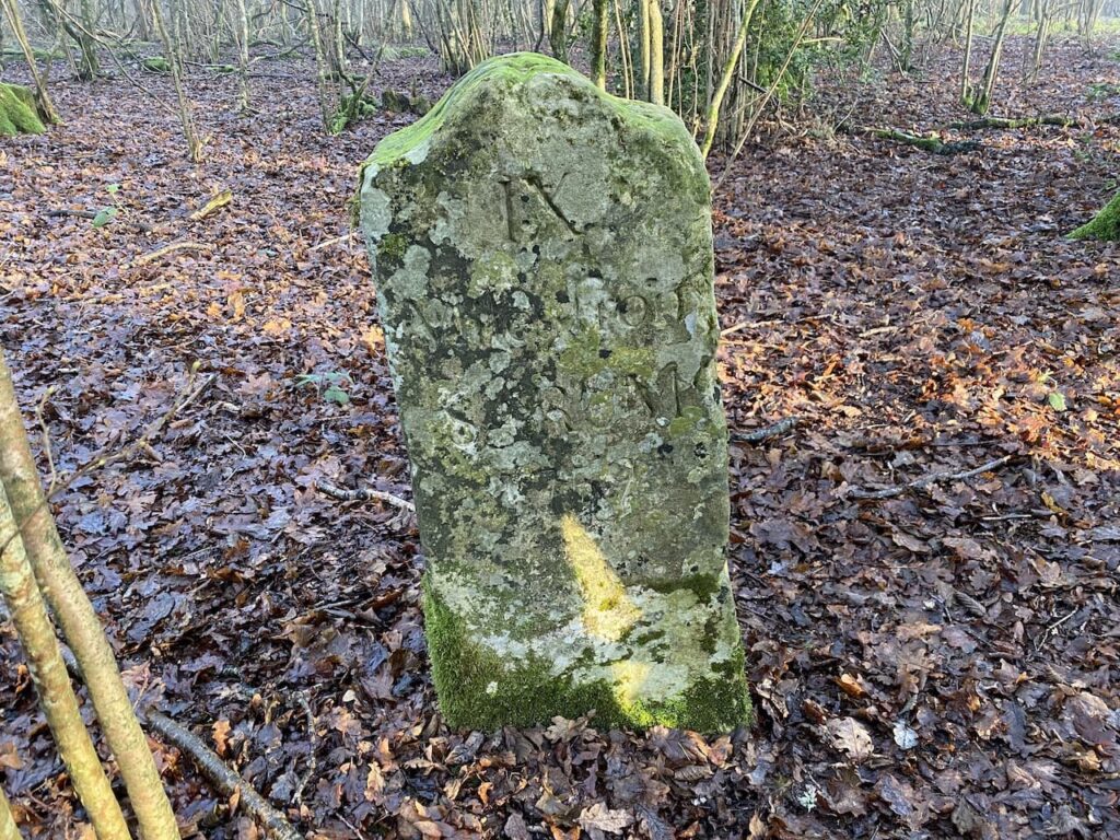
This track is an ancient drove known as Ox Drove, a common term in this area for a track which was used to drive cattle to market. This particular route linked Chicklade and Wilton and we soon encounter an old milestone sitting to the left of the track. It is dated 1759 and indicates that we are 9 miles from Sarum, the old name for Salisbury.
It is a cracking morning and the frost still lies on the ground as we head along the drove.
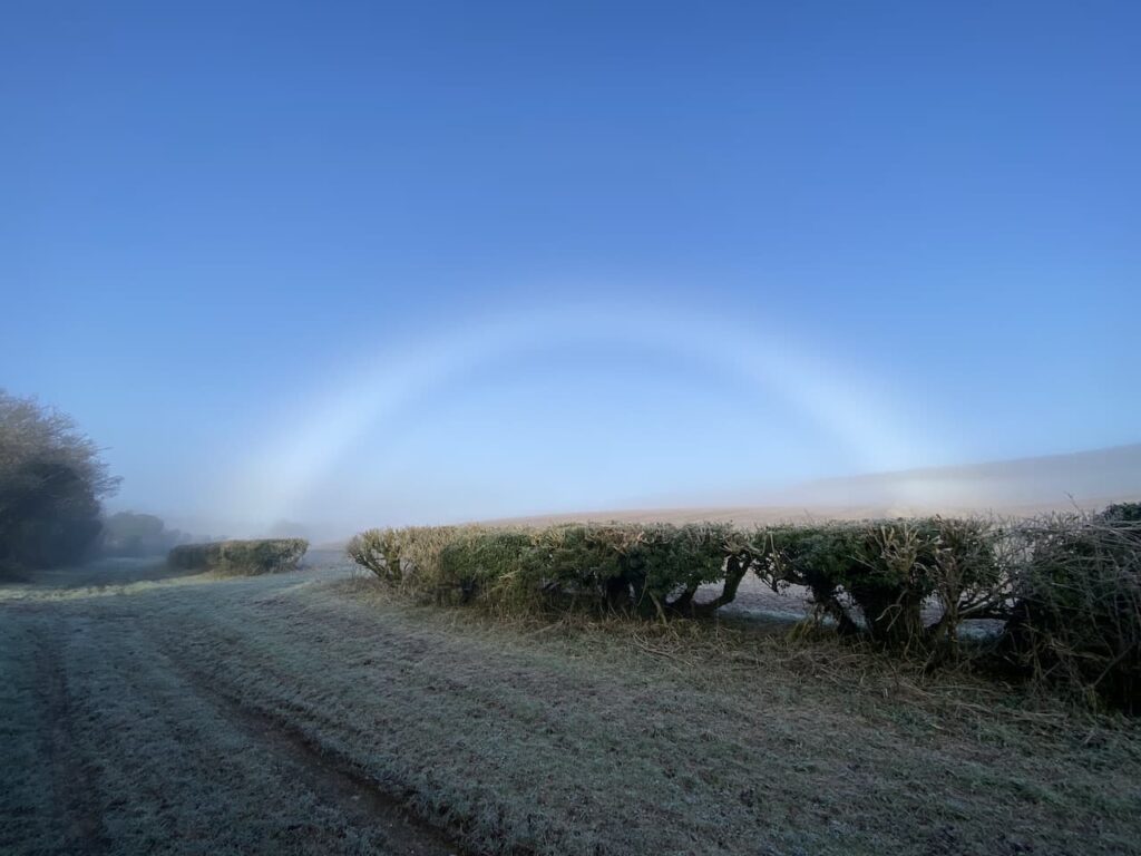
Stopping to take in the view behind us I spot a stunning fog bow. This is similar to a rainbow, but is created by the sun interacting with water droplets in the fog. I cannot recall seeing one before.
The Ox Drove we are following is also part of the Monarch’s Way, a long distance walking route retracing the journey made by Charles II after the battle of Worcester. The 615-mile way starts from Worcester and after a convoluted route reaches the Dorset coast and then heads east to finally end at Shoreham-on-Sea.
At a junction with Fir Drove we stay with the Ox Drove and Monarch’s Way to head uphill in an easterly direction.
At a junction of tracks just before West Thornhills copse we leave the Monarch’s Way, which forks to the left. We stay on Ox Drove forking right to pass the copse and carry on to reach East Thornhills.
The track now descends to a junction of paths and a minor road. There is a small parking area here and another milestone beside the path bears the inscription “VI Miles from Sarum 1750” .
We continue east on the Ox Drove, ascending again we get fine views across to Cranborne Chase with the fog still lingering in the valley to the south.
Just before reaching a junction of paths we pass another milestone. The inscription on this stone is difficult to make out, apparently it said “V Miles to Sarum 1750”.
At the junction of paths we continue straight on towards Ugford Red Buildings.
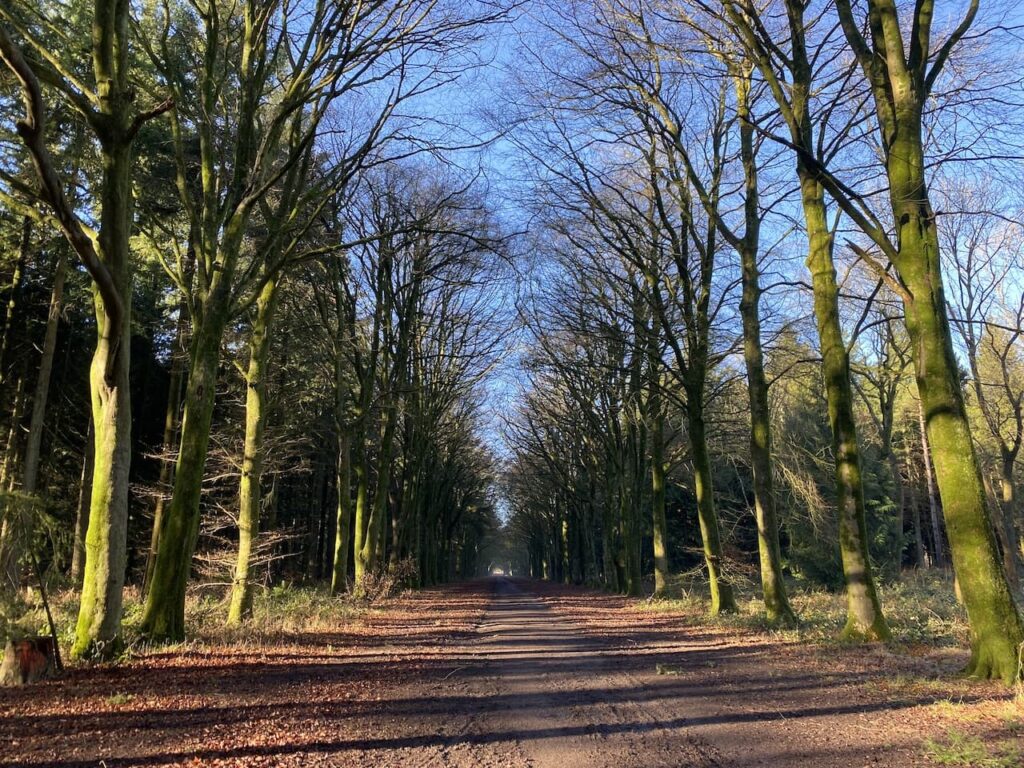
At a junction of paths by the farm buildings we turn left and keep left as the path forks, this takes us along a line of attractive beech trees.
At a junction of paths we turn right and then after a couple of hundred yards take a left along the wide track called First Broad Drive.
After 500 yards, shortly before the Grim’s Ditch joins the drove, we turn left into the trees to visit the Handsel Sisters. These are ancient beech trees within this section of pine woodland.
The Handsel sisters were born in Denmark in the 1700’s and moved to the Wilton area. Soon after they arrived an outbreak of smallpox claimed 136 lives. Locals were convinced the sisters were responsible for the deaths and they were accused of witchcraft and an alliance with the devil. Without an official hearing they were taken to Grovely Woods and bludgeoned to death. They were then buried some distance apart to stop them conspiring against their murderers.
There are conflicting tales about the origins of the beech trees, one is that they were planted to mark the graves as a warning to others who might consider practicing witchcraft. The other that the trees grew on top of the unmarked graves as a reminder to locals of their murders.
Of the four original trees three remain. The largest of the trees is strewn with offerings to the sisters. There are reported sightings of the ghosts of the sisters in this area of woodland and pages on the internet dedicated to the spooky goings on here. I am not sure what to believe, but the trees have grown in a very strange way and there is certainly a feel about this area that makes me slightly uneasy.
Having visited the trees we make our way back to First Broad Drive and follow this heading west. Shafts of sunlight are shining through the trees giving a dramatic effect.
It is very pleasant walking along the wide track feeling the warmth of the sun. This is just the sort of thing to lift the spirits, walking with friends in cracking woodland in the sunshine!
At a crossing of tracks close to Grovely Lodge we continue straight on to join Second Broad Drive. We decide to take advantage of the sunshine and stop besides the track for some lunch.
We don’t hang about too long because despite the sun it soon feels chilly when you are inactive. Continuing along Second Broad Drive we pass Four Sisters Copse and then leave the main track turning right to follow a path through the trees heading northwest towards the Little Langford Down Nature Reserve. Like much of Grovely Wood this is open access land so there are no way-markers and we take care to ensure we skirt the top of a valley before turning north through Langford Woods.
This is a stunning section of woodland maintained as a nature reserve by the Wiltshire Wildlife Trust. We stay with a broad ride through the trees to reach the northern end of Langford Woods where there is a barbed wire fence. This marks the edge of the access land. Here we make a brief excursion into the field to visit the Ordnance Survey trig pillar on the ramparts of Grovely Castle Iron Age hill fort.
Back in the woods we retrace our steps through the nature reserve, this time when we reach the top of the valley we fork right on a ride passing an area marked on the map as Powten Stone. Despite searches over many years by many people the actual location of the stone is unknown but it still justifies being recorded on the map.
We rejoin the Second Broad Drive and turn right to head west. During the Second World War these woods played an important role as a storage location for ordnance. As a result the old Roman Road which we are now walking along was paved to allow easy access for military vehicles.
Apparently bombs were stored in the woods and fuses and other volatile munitions were stored in hundreds of bunkers. A couple of these bunkers still remain and one is located by the track, it is easy to identify because someone has sprayed ‘Bunker” by the entrance.
We stop to have a peek inside, I am not sure I would have wanted to be in such a confined space with volatile ordnance.
Our route continues along Second Broad Drive, it is getting late in the afternoon and the sun has lost its warmth and there is a definite chill to the air.
We keep our eyes peeled for a second bunker besides the track, this one is not so easy to find because it is overgrown. This one has been bricked up presumably to prevent it from being damaged.
We stay with Second Broad Drive until we reach the edge of the woods, here we turn left besides a barn and follow a track along the northern edge of the wood to reach a minor road. We turn left to walk through Dinton Beeches and return to our starting point.
We have covered over thirteen and half miles and it has been a cracking walk. The sunshine and company of friends has gone a long way to lifting my spirits. Roll on spring!
All information on this site is provided free of charge and in good faith and no liability is accepted in respect of damage, loss or injury which might result from it. To the best of my knowledge the routes are entirely on public rights of way or within areas that are open for public access. Walking can be hazardous and is done entirely at your own risk. It is your responsibility to check your route and navigate using a map and compass.
The start of a new year sees me starting another “Walk the Year” challenge. In 2021 I aim to walk 2,021 miles. I started doing this annual challenge in 2018 so this is my fourth year. In my quest I only count “Boots on Miles” which means the miles I notch up whilst wearing my walking boots. Normal day to day walking does not count as far as I am concerned. In 2020 I walked 2,542 miles which far exceeded previous years; 2,231 miles in 2019 and 2,229 in 2018.
It is a bright but frosty morning so ideal for walking at pace to keep warm and I intend to start the year with a good long morning walk from Pitton, my home village.
I start my walk from the village pub, the Silver Plough, leaving the car park I turn left and then immediately left along The Green. I ignore footpaths to the right and left and stay on the lane to reach a bridleway opposite Glebe House. At the end of the bridleway I turn right to walk up the track, Winterslow Hollow.
I ignore a footpath on the left and then within 10 yards turn left to join the permissive path running along the fence line and then continue between fields to reach farm buildings. The footpath goes to the left of the farmhouse and then on reaching a track I continue the short distance to a road. I cross and carry on along a track alongside All Saints Church on the edge of Winterslow.
Through a kissing gate I keep to the left hand side of the field to reach another kissing gate, here I keep close to the fence and soon reach another two kissing gates side by side. I go through the one on the left and follow a fence lined path and stay with it as it leads into a copse. The path is easy to follow through the trees and soon turns to the left to descend to a sunken track, here I turn left and head downhill.
This is part of the Monarch’s Way, a route that follows the journey made by Charles II after the battle of Worcester. The 625-mile route starts from Worcester and after a convoluted route reaches the Dorset coast and then heads east to finally end at Shoreham-on-Sea. It is a walk I would love to do, but I would need a long pass from Lynnie before I could consider it!
As I continue along the track I am mentally planning the logistics of tackling a walk of over 600 miles. At the moment it feels like it will be some time before such a walk would be possible, but it is potentially something to add to my list of winter projects. The track leads to a road where I turn right and follow a path on the verge. At a crossroads besides a wind pump I turn left back towards Pitton, after about a hundred yards I take a footpath on the right just after the entrance to Windmill Farm. I am still on the Monarch’s Way.
This fenced path leads between fields then reaches a play area at the back of houses in Firsdown. The route continues west, following the course of a Roman Road, to reach a copse. I stay on the main path still heading west through the trees. There are no other footpaths marked on the map for these woods, but obviously local dog walkers have established a few routes. At a clearing in the hedge line I stop to look at the view back towards Pitton.
The next section of the walk looks a bit complex on the maps, but on the ground the footpaths are clear. I emerge from the wooded area and continue straight ignoring a path on the right. Within a few yards I carry straight on at a crossing of tracks and then at the next crossing of tracks, within a hundred yards, I turn right. This path is way-marked as the Monarch’s Way.
A few hundred yards along this path I reach a stile on the left and cross this, still on the Monarch’s Way, from here I follow the path along the right hand edge of a field.
The path passes through a gate before heading along a driveway to a stable to reach the A30. On the far side I go through a gate and walk besides a field to reach a stile on the right giving access to the Neolithic and Iron Age site of Figsbury Ring.
After wandering around a section of the ring I rejoin the Monarch’s Way, leaving the access land by a gate in the western corner of the field I join a track descending towards the Winterbournes.
I go through a kissing gate besides a farm gate and continue along a tarmac lane that goes under a railway bridge to reach the village. The lane leads to the A338 where I turn left by St Michael and All Angels Church. After a few hundred yards on the pavement besides the main road I turn right into Tanners Lane and follow this lane as it heads to the River Bourne. I stay with the lane until it reaches a ford, here I take the footbridge and cross the river.
After crossing the river I turn left along a track and then at a junction of tracks turn left to cross the river again. At a junction I turn right into Hurdcott Lane and then after a couple of hundred yards turn right into Black Horse Lane and pass the Black Horse pub.
At the end of the lane I join a footpath and follow this as it skirts the edge of a field and then goes through the hedge line into a second field to continue on to a footpath running behind houses. This soon opens up into a driveway to properties and then reaches a minor road in Ford where I turn left and walk up to Broken Cross Bridge that crosses the railway line. After carefully crossing the bridge I turn left into Old Malthouse Lane. After a couple of hundred yards just as I reach industrial barns I take a footpath on the right and follow the path steadily uphill towards the A30.
After crossing this busy main road the path continues on the far side through a hedge to follow a farm track along the side of a field.
At the top corner of the field I turn right and follow the edge of the field to join a path leading through bushes to reach a kissing gate onto the open access land of Cockey Down Nature Reserve.
When I was a nipper this hill briefly gained national notoriety when on 26th January 1969 a group of students from University College North Wales carved a chalk Panda onto the hillside as part of a RAG week stunt. The Panda remained visible for some time, but has long since grown over. It is a few months since I was last here and as I walk around the trees I am surprised to see a monolith has been erected.
I walk away from the monolith on a path that descends steeply and continues south on Laverstock Down. Here I bump into a couple heading up the hill and they inform me that the monolith appeared overnight and they are eager to catch a glimpse.
Continuing along the path I encounter a steady stream of people heading up the hill to view the new phenomenon (as it later turns out they were right to do so because 3 days later it was pulled down). At a fork in the path I go left and head uphill to reach a kissing gate and then follow a hedge lined path to reach the gates for Clarendon Estate at Rangers Lodge Farm. I turn left, now on the Clarendon Way and follow the Estate Road before forking right onto the footpath to cross a field heading towards King Manor Hill.
The path continues up a track and as it bends to the right I continue straight on to visit the remains of Clarendon Palace. This Royal Hunting Lodge was a major residence of Kings from the reign of Henry II to Henry VII. When I was a youngster the site was overgrown and the ruins were lost in the undergrowth, now they have been cleared and it is an interesting, historic spot to visit.
I leave the site of the palace by a gate in the north east corner and rejoin the Clarendon Way and turn left along a track. Within a hundred yards I fork left leaving the track to follow the Clarendon Way sign into the woods. I now stay with the Clarendon Way as it follows a clear path through the trees to reach farm buildings and then continues around the back of Four Cottages and back into Pitton. At the crossroads I turn right and walk up White Hill to reach my starting point at the Silver Plough.
My walk has covered just over 13 miles and has been a great start to my walking year. It has been a very chilly day but the occasional sunshine has made for pleasant walking.
All information on this site is provided free of charge and in good faith and no liability is accepted in respect of damage, loss or injury which might result from it. To the best of my knowledge the routes are entirely on public rights of way or within areas that are open for public access. Walking can be hazardous and is done entirely at your own risk. It is your responsibility to check your route and navigate using a map and compass.
I am continuing my quest to walk areas close to home I have not previously explored. So today I am off to Grovely Wood on the west side of Wilton for a walk with my friend Mandy. There are a number of options for parking around the woods, we choose the small car park on Grovely Road to the south west of Great Wishford.
We start our walk by heading up the forestry track into the woods on the route of the Monarch’s Way.
It is a steady ascent through the trees and we stay with this track until meeting a crossing of tracks close to Grovely Lodge here we turn right along a wide track and soon pass a gate and continue along the track.
After passing Four Sisters Copse we leave the main track and follow a path through the trees heading northwest towards the Little Langford Down Nature Reserve. Like much of Grovely Wood this is open access land so there are no way markers and we take care to ensure we skirt the top of a valley before turning north through Langford Woods.
This is a stunning section of woodland maintained as a nature reserve by the Wiltshire Wildlife Trust.
We stay with a broad ride through the trees to reach the northern end of Langford Woods where there is a barbed wire fence. This marks the edge of the access land. Here we make a brief excursion into the field to bag the Ordnance Survey trig pillar on the ramparts of the Grovely Castle Iron Age hill fort.
This is the 233rd trig I have bagged and the views from here are stunning.
We spend a few minutes just taking in the far ranging views and once again I am blown away by the beauty of the Wiltshire downland.
Back in the woods we retrace our steps through the nature reserve, this time when we reach the top of the valley we fork right on a ride passing and area marked on the map as Powten Stone. I had hoped this would mean there was a stone here we could seek out, but whilst planning the route I discovered that despite much searching the location of the stone is unknown.
On reaching a junction with a footpath following the line of a Grim’s Ditch we turn right following the path as it goes along the edge of the woodland besides the ditch. A Grim’s Ditch is not an uncommon site when walking on chalk downland. Apparently their exact purpose is unclear, they are not large enough for military purposes it is therefore thought they were used to mark territorial boundaries and date from around 300 BC. The ditch is to our right and we soon pass a small pond.
Our route is now very straightforward, we stay on the path along the edge of the woodland with the occasional clearing to our right giving stunning views.
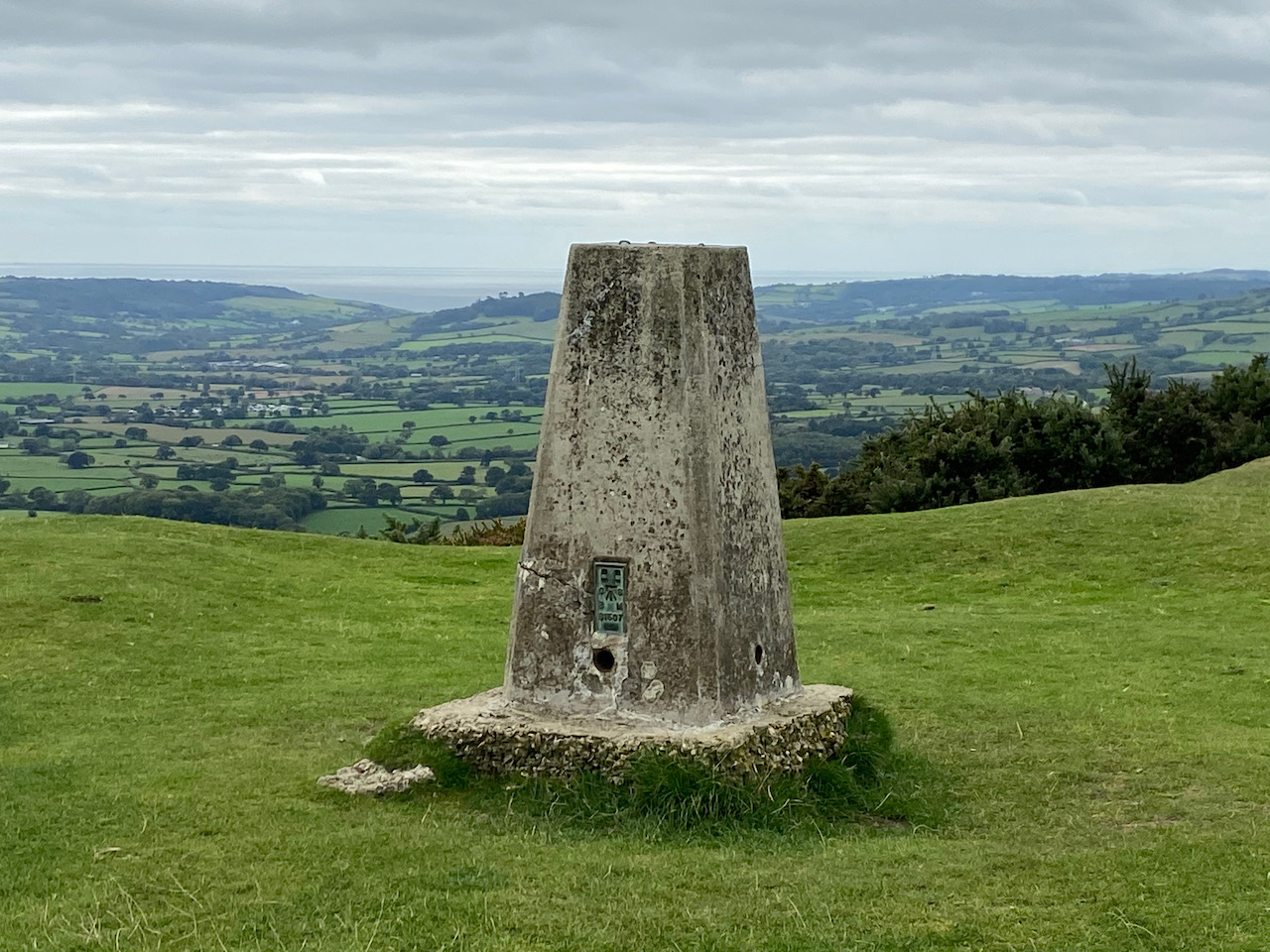
We pass a barn and stay with the track until we reach a minor road at Dinton Beeches, here we turn right along the road for a couple of hundred yards to make a brief diversion from our route to visit the Ordnance Survey trig pillar at West Hill, my 234th.
This is another trig with great views across the Wylye Valley. Now we head back along the road to Dinton Beeches and take a track into the trees which heads south. At a junction of paths we turn left and head along the southern edge of the copse to reach a minor road.
We cross and pass a parking area and head along the drove on the route of the Monarch’s Way.
The Monarch’s Way is a long distance walking route retracing the journey made by Charles II after the battle of Worcester. The 615-mile route starts from Worcester and after a convoluted route reaches the Dorset coast and then heads east to finally end at Shoreham-on-Sea. Over recent years I have walked a number of sections of the route, but this is the first time I have walked this stretch.
This track is also an Ox Drove, a common term in this area for a track which was used to drive cattle to market. This particular route linked Chicklade and Wilton.
The route is easy to follow we stay with the Monarch’s Way along the Ox Drove passing through farmland to reach a junction of paths with Fir Drove, here we stay with the Monarch’s Way to head uphill heading east.
At a junction of tracks before reaching West Thornhills copse we leave the Monarch’s Way, which forks to the left, and take the right fork staying on the Ox Drove passing the copse and carrying on to reach East Thornhills. Here we take a diversion from the track to hop into the field to bag the clearly visible trig point on Crouch’s Down, my 235th.
When bagging trig points on arable land I always seek to visit them at a time when there are no crops in the field. This is perfect, the field is still stubble from last year’s harvest. This is another trig with cracking views.
Back on the Ox Drove we continue east, ignoring footpaths off the main track to reach a junction at the end of a minor road. There is a small parking area here and at the crossway of paths there is a milestone with the inscription “VI Miles from Sarum 1750”.
We continue on the Ox Drove heading east and the track now heads uphill with more stunning views.
Then we come across another milestone to the right of the track. This is a large stone but the inscription has eroded. We can just make out a “V”, but the rest is too faint to read. Apparently it said “V Miles to Sarum 1750”.
We come to a crossing of paths, but continue straight on towards Ugford Red Buildings.
At a junction of paths by the farm buildings we turn left and keep left as the path forks, this takes us along a line of attractive beech trees.
As we near a hedge line of a field we take a diversion to follow the hedge line south to the Ordnance Survey trig pillar on Grovely Hill. I have previously bagged this trig, but it is worth a revisit.
Leaving our fourth trig of the day we walk back to the footpath and then continue north west through the trees. At a junction of paths we turn right and then after a couple of hundred yards take a left along the wide track called First Broad Drive. After 650 yards, just before the Grim’s Ditch joins the drove, we turn left into the trees in search of the Handsel Sisters. These are ancient beech trees within this section of pine woodland.
The Handsel sisters were born in Denmark and moved to the Wilton area. Soon after they arrived an outbreak of small pox claimed 136 lives. Locals were convinced the sisters were responsible for the deaths and they were accused of witchcraft and an alliance with the devil. Without an official hearing they were taken to Grovely Woods and bludgeoned to death. They were then buried some distance apart to stop them conspiring against their murderers.
There are conflicting tales about the origins of the beech trees, one is that they were planted to mark the graves as a warning to others who might consider practicing witchcraft. The other is that the trees grew on top of the unmarked graves as a reminder to locals of their murders.
Of the four original trees three remain. The largest of the trees is strewn with offerings to the sisters. There are reported sightings of the ghosts of the sisters in this area of the woods and pages on the internet dedicated to the spooky goings on here. I am not sure what to believe, but the trees have grown in a very strange way and there is certainly a feel about this area that made me slightly uneasy. I would definitely not wander up here after dark!
Back on the First Broad Drove we head west to soon pass a permitted bridleway on the right.
A few hundred yards further on at the next ride we turn right and follow this to a five ways junction of tracks here we go left following a ride going northwest and keep heading in this direction at two further ride junctions. The path we are on starts to descend steadily towards the forestry track we had started our walk on.
On reaching the track we turn right and walk a couple of hundred yards back to our starting point. Our walk has covered just over fifteen miles. It has been a cracking day with sunshine all round and some stunning views. I am sure I will be returning here again very soon to walk with Lynnie.
All information on this site is provided free of charge and in good faith and no liability is accepted in respect of damage, loss or injury which might result from it. To the best of my knowledge the routes are entirely on public rights of way or within areas that are open for public access. Walking can be hazardous and is done entirely at your own risk. It is your responsibility to check your route and navigate using a map and compass.
Before the year is out I plan to visit the highest point in Wiltshire at Milk Hill on a walk which will include bagging the Alton Barnes White Horse. It is therefore interesting to discover we are currently staying not too far away from what for years was thought to be the highest point in Dorset at Pilsdon Hill.
The starting point for our walk is the Lay-by besides the B3164 at the southern side of the hill fort (Grid Ref: SY414009). From the lay-by we cross the road and enter the National Trust land around Pilsdon Pen.
After reading the information board we commence the steady ascent up to the summit of the hill.
There are cracking views as we go up so stop to look behind us.
The path reaches the plateau on the top of the hillfort and we stop to bag the Ordnance Survey Trig Pillar, my 217th successfully bagged.
The Iron Age hill fort is built on what was for many years thought to be the highest hill in Dorset standing at 909 feet above sea level. More recently it was discovered that nearby Lewesdon Hill is about six feet taller.
Our route takes us north across the plateau on the route of the Monarch’s Way, on reaching the ramparts on the northern side of the hill fort we turn right.
This route is now both part of the Monarchs Way and the Wessex Ridgeway and on reaching a gate we follow the way-markers.
We descend across fields to cross a minor road and join a farm track towards Lower Newnham Farm. As the track nears the farm house we follow a permissive path diverting the footpath away from the front of the house. I have no problems with such diversions as long as they are well maintained and clearly marked, as this is. Leaving the farm we follow a track and then cross a stream and head uphill across a couple of fields. At a junction of paths we turn right, leaving the Monarch’s Way but staying with the Wessex Ridgeway along an old lane, Sheepwash Lane.
At the B3164 we turn left and walk a couple of hundred yards besides the road to reach an old lock-up where we leave the road and take the left fork on a footpath to follow the Wessex Ridgeway as it gradually ascends Lewesdon Hill Lane.
We keep with this path as it goes uphill.
On reaching a three way split in the track we go right, I had initially intended to go to the top of Lewesdon Hill but there are quite a few folk about and as we are being very careful we decide it will be easier to social distance on the quieter lower path.
We stay with the clear path as it goes through the trees to reach a junction of paths at Crabb’s Hill, here we turn right and follow the clear path as it steadily descends to a lane. We turn left and the very quickly take a footpath on the right heading diagonally across fields .
On reaching a lane we turn right and follow it steadily downhill to Blackney. At a junction in the village , next to a cracking carving of an owl, we take the lane signposted to Pilsdon.
This lane heads west and after half a mile, when the lane bends to the right, we carry straight on along a driveway for Gerrard’s farm. In a couple of hundred yards the driveway sweeps to the left but we continue straight on taking a footpath heading west across fields towards a copse. On reaching the copse we take a path on the right going through the trees and then continuing across fields towards Pilsdon.
We pass through a gate and join a farm track for Pilsdon Dairy Farm and carry on to St Mary’s Church which forms part of the Pilsdon Community. This Community was founded in 1958 by Reverend Percy Smith and Gaynor Smith to provide a refuge for people in crisis, supporting them through prayer and community living. Up to twenty-five people are accommodated in Pilsdon Manor and the church forms part of their daily prayer routine.
From the church we continue along the lane towards the village and on reaching a junction go right heading north on a lane signposted to Broadwindsor. We stay with this lane as it heads out of the village, then turn left at a T-junction to ascend to the B3164 and our starting point at the car park.
Our walk has covered just over seven miles and we stop to look at the view from the car park which is out towards the coast and Lyme Bay. We decide to pop down to Lyme Regis for a wander about and a fish and chip supper. Crosby is very excited at this news, he has a liking for both fish and chips!
All information on this site is provided free of charge and in good faith and no liability is accepted in respect of damage, loss or injury which might result from it. To the best of my knowledge the routes are entirely on public rights of way or within areas that are open for public access. Walking can be hazardous and is done entirely at your own risk. It is your responsibility to check your route and navigate using a map and compass.
Over twenty years ago I purchased a guide to The Sarum Way, a circular walk around Salisbury and Wilton covering over thirty miles. I have often thought about tackling this walk but in normal times we spend long periods away in the caravan and I have difficultly finding a whole day at home when I can head out.
During the lock down period I came across the guide and whilst plotting the route realised some of the original permitted paths through Clarendon Estate are no longer accessible and starting from my home village would lengthen the route to around thirty three miles. A good days walking!
My walk starts from outside the Silver Plough pub in Pitton. Leaving the car park I cross the road and take the track to the left of the village hall passing the village playing field. Just after the tennis court the footpath leaves the track and follows a parallel route on the left. This leads into a copse where just after passing Coldharbour Cottage I fork left and head steadily uphill through the copse to reach a fence lined path along the ridge with memorial benches.
At a junction of paths I continue straight on along a track, Cock Row, so called because in medieval times local peasants used to net Woodcock along it. I stay with this track until I reach a tarmac drive where I continue straight on to a junction with Lucewood Lane. Here I turn right and walk along the road. At a T-junction I turn left onto Clarendon Road and after a couple of hundred yards fork right into Green Drove.
At the bottom of the drove I carry straight on to cross the River Dun and then go right following the road through the village of West Grimstead to reach a green with a bench. From the green I follow a path running inside a hedge parallel to Grimstead Road heading towards Whaddon.
Nearing Whaddon the path joins a pavement and crosses the A36. I then continue down the road to a junction where I turn right onto the Southampton Road. Prior to the by-pass this was the main Salisbury to Southampton route. Within a hundred yards I turn left opposite the village shop to walk along an unmade road, Castle Lane. When the lane forks I go left and then join a footpath on the right and stay with this to pass Matron’s College Farm.
This footpath crosses the disused Salisbury and Dorset Junction Railway and continues on a clear track across arable fields.
At a junction of footpaths I turn right and after crossing the disused railway line again turn left and walk along a permissive route parallel to the railway line. The Salisbury and Dorset Junction Railway was an 18 mile line spurring from the Salisbury Southampton line at a junction in Alderbury through Downton and Fordingbridge to West Moors where it connected with the main Southampton to Dorchester line. The line was completed in 1866 and operated until May 1964. This section of the line ran through a deep cutting.
I keep the disused railway to my left until I reach Four Gates, after passing through a gate I turn right and walk along a minor road to reach a junction with Witherington Road where I turn right and follow this minor road downhill towards Standlynch Farm. Just before the entrance to the farm I take a footpath on the left which heads into woodland.
These woods are part of the Trafalgar Park estate and after passing through a gate I catch a glimpse of the main house. As you might imagine with a name like Trafalgar this estate has connections with Admiral Horatio Nelson. Following Horatio’s death at the Battle of Trafalgar in 1805 his brother Rev William Nelson was created 1st Earl Nelson and apparently lobbied Parliament for an estate in recognition of his brother’s service to the Nation. Standlynch Park was the location chosen by the Treasury and it was renamed Trafalger Park. Descendants of Horatio Nelson lived here until 1948 when it was sold by the 5th Earl Nelson.
After crossing a field I go through another gate to follow a track through woods. I stay with this path until I reach a concrete path. Here I turn right and head downhill to reach the disused Standlynch Mill.
This is a cracking spot besides the River Avon.
The footpath goes over weirs on the river. This spot is absolutely stunning.
After a series of small footbridges I reach a field and fork right to head towards Charlton-All-Saints. The exit from the field is by way of an unusual turnstile gate.
I now turn left along a path to reach a road running through the village where I turn right and walk along Lower Road. At All Saints Church I turn left into Church Lane.
After a few hundred yards on Church Lane I take a footpath on the right across a field. This is the Avon Valley Path and I stay with it to cross further fields to reach a minor road where I turn right and follow the lane passing old barns and Matrimony Farm House.
At a footpath on the left I leave the road and cross a field to reach the A338 which I cross with care to join a footpath heading uphill besides a field. After 250 yards I go through a gate on the right to follow the Avon Valley Path as it crosses a field of pasture. After passing through another gate I join a track and follow this past a farmyard to reach a minor road.
I continue straight on along the road passing houses, then as the road turns to the left I take a footpath opposite to head through fields towards Odstock Farm. After some farm buildings I continue in a westerly direction to cross a field and then follow a path leading to a minor road where I turn right and walk into Odstock to reach the Yew Tree Inn.
Passing the pub I go straight over the crossroads and keep on the road for 500 yards, crossing the River Ebble, to find a footpath on the left besides a small lay-by. The path initially goes through bushes and then reaches arable fields.
This is a well-worn path that I am heading west on. I ignore a path on the left and continue to a crossing of paths, I turn right and go steadily uphill to reach a drove where I turn left and follow the track to reach the A354 Blandford Road.
After crossing the road I take the track opposite, The Old Shaftesbury Drove, to reach a track junction where I turn left. Sadly this drove appears to be a popular location for fly tipping.
The drove continues past properties and then becomes a hedge lined track rising steadily towards the race plain. As the track starts to level the railings of the racecourse can be seen on the right with fine views beyond of Salisbury Cathedral.
This racecourse hosts flat racing and lays claim to being the venue where on 7th April 1948, Lester Piggott, aged twelve, rode his first race and also the course where the famous American jockey Steve Cauthen rode his first race in Britain.
The track continues to join a tarmac driveway and passes a caravan site and the race course grandstand. Soon after passing the stables on the left I reach the remains of Cowper’s Cross on the grass verge.
Continuing along the tarmac driveway I reach a minor road which I cross to continue along the Old Shaftesbury Drove passing Hare Warren. After three quarters of a mile I join a minor road. I turn right walking besides the road for just over 100 yards to an entrance into woodland on the left. I follow the path through the trees, ignoring paths to the right and left and occasionally enjoying fine views between the trees to the right.
The woodland track reaches a stony track, turning right I gradually descend towards South Burcombe, pausing on route to admire the stunning contours of the Punchbowl valley on the left.
After passing converted barns at Manor Farm I reach a minor road, which I cross and carry on north to cross the River Nadder, this is the third of Salisbury’s five rivers I have crossed today.
This minor road leads to the A30 opposite the church of St John, an interesting church because unusually it has a tower that is lower than the nave roof. It is of Saxon origin, restored over the years, but apparently in 2005 the Church Commissioners declared the church redundant and it is now closed.
After visiting the church I head east on the pavement besides the A30 to reach a footpath on the left. I cross the road and take the footpath heading up to cross the main Exeter to Salisbury railway line before continuing steadily uphill towards a barn. Here the track turns left and soon after right to continue the steady ascent of the hill.
Soon after passing farm buildings on the left I reach a crossing of paths, my route is straight on and I stay with the waymarked route as it enters trees.
At a junction of paths close to a Grim’s Ditch I make a short diversion, turning right along a track through the trees and then follow the hedge line on the right to reach the Ordnance Survey trig pillar on Grovelly Hill. This is the 208th I have bagged.
From the trig pillar I retrace my steps and continue north through Heath Wood, passing an ancient earthworks and staying with the way marked route.
At a crossing of tracks I go right and descend to the edge of the woodland to cross a stile into a field. I go right along the fence line and enter another field and then go left to join a path across access land above a stunning valley.
The path descends steadily to a stile which I cross and continue diagonally across an arable field to reach a track.
I walk under the railway line to join a minor road turning right and then within a few yards I take a footpath on the left leading down to the River Wylie. This offers an ideal bench besides the river a perfect spot for lunch.
After my break I resume the walk continuing besides the river to a footbridge leading into South Newton. Besides the path, in the field to the right, is a World War II pillbox.
On reaching the village, where the busy A36 runs through, I turn right to walk on the pavement to reach Forge Close on the opposite side of the road. I cross with care into the Close and then carry on besides allotments. After passing more houses the footpath turns right to head out onto an arable field. At the field boundary I turn left on a track heading steadily uphill. At a fork in the track the path goes to the right and heads onto downland with fine views.
I continue along the top of the downs with a fence to my right to reach a stile near a copse. After crossing I follow the path towards telecom aeriels at the top of the hill.
After passing the masts the route follows a track and soon arrives at an Ordnance Survey trig pillar on the hedge line, this becomes my 209th bagged trig.
Further along the track I pass the Bronze Age burial chamber of Newton Barrow. Apparently excavation work in 1805 discovered a skeleton with amber beads and eighteen perforated wolves and dogs’ teeth, thought to have been a necklace. These days the barrow is only a small mound besides the track.
On reaching the A360 I cross and take the footpath opposite heading towards woodland. As I reach the edge of the trees the path turns to the right and starts the long steady descent towards Lower Woodford.
After passing farm buildings I carry on down to the village. I have now joined the Monarch’s Way; this route gets its name from following the escape route taken by King Charles II in 1651 after his defeat by Oliver Cromwell at the Battle of Worcester. The route is 625 miles long, starting in Worcester and travelling through Stratford upon Avon, Stow on the Wold, Cirencester, Bristol, Yeovil and then through Dorset to continue along the south coast to Brighton before ending at Shoreham-by-the Sea. In recent years I have walked a number of sections of this long distance path but this part is new to me.
In the village I turn right and then almost immediately left, just after the Victorian Wall Postbox, taking a waymarked path through a gate besides a cattle grid. It then passes along the drive of a property to reach a bridge over the River Avon.
After crossing the river the path goes uphill to a minor road where I turn left and then almost immediately right at Salterton Farm. Keeping the farmyard to my left I go through a gate.
The path goes steadily uphill with good views of the Woodford Valley.
I stay with the Monarch’s Way path as it heads towards the A345 at Longhedge. Until recently Longhedge was farm land but these days it is a vast housing development, part of the expansion of Salisbury. It won’t be too long before the houses reach the Monarch’s Way path.
Crossing the A345 still on the Monarchs Way I follow a drove to reach a road known as Portway, there is a World War II pillbox in the field to my right.
I cross the road and start to descend towards Hurdcott. As I near the village the Monarch’s Way goes to the left but I continue straight on, crossing the River Bourne, my fifth Salisbury river of the day, before turning right into the village and shortly after take another right into Black Horse Lane, passing the Black Horse pub.
At the end of the lane I join a footpath and follow this as it skirts the edge of a field and then goes through the hedge line into a second field to continue running behind houses. This soon opens up into a driveway to properties and then reaches a minor road in Ford where I turn left and walk up to Broken Cross Bridge, that crosses the railway line. After carefully crossing the bridge I turn left into Old Malthouse Lane. After a couple of hundred yards just as I reach industrial barns I take a footpath on the right and follow the path steadily uphill towards the A30.
I cross the main road with care and continue on the far side through a hedge to follow a farm track along the side of a field. The path ascends steadily with some fine views back across Salisbury.
At the top corner of the field I turn right and follow the edge of the field to join a path leading through bushes to reach a kissing gate onto the open access land of Cockey Down Nature Reserve. My route follows a path along the top of the downs towards a clump of trees.
After passing through the trees the path descends steeply and continues south on Laverstock Down.
At a fork in the path I go left and head uphill to a kissing gate and then follow a hedge lined path to the Clarendon Estate gates at Rangers Lodge Farm. I turn left, now on the Clarendon Way and follow the Estate Road before forking right onto the footpath that crosses a field heading towards King Manor Hill.
The path continues up a track and as it bends to the right I continue straight on to visit the remains of Clarendon Palace. This Royal Hunting Lodge was a major residence of Kings from the reign of Henry II to Henry VII. When I was a youngster the site was overgrown and the ruins were lost in the undergrowth, now they have been cleared and it is an interesting, historic spot to visit.
I leave the site of the palace by a gate in the north east corner and rejoin the Clarendon Way and turn left along a track. Within a hundred yards I fork left leaving the track to follow the Clarendon Way sign into the woods.
I now stay with the Clarendon Way as it follows a clear path through the trees to reach farm buildings and then continues around the back of Four Cottages and into Pitton. At the crossroads I turn right and walk up White Hill to reach my starting point at the Silver Plough.
I have clocked up just over 33 miles, a good days walking. It has been a really interesting walk, some sections I have walked previously but to take on the whole route in one day has been a good challenge. Now it is time for a reviving cup of tea before taking the dogs out for a walk!
To follow my walk you will need Ordnance Survey Explorer Maps OL130 Salisbury & Stonehenge and OL131 Romsey, Andover & Test Valley
For more information on this walk including car parking, amenities, refreshments and detailed walking directions visit my associated Walking Moonraker website.
All information on this site is provided free of charge and in good faith and no liability is accepted in respect of damage, loss or injury which might result from it. To the best of my knowledge the routes are entirely on public rights of way or within areas that are open for public access. Walking can be hazardous and is done entirely at your own risk. It is your responsibility to check your route and navigate using a map and compass.
For a long time I have planned to do a circular walk from home taking in the Iron Age Hillfort at Figsbury Ring and then crossing Cockey Down to return back to Pitton via Clarendon Palace. At this time of year we usually spend a lot of time away in the caravan, but with the current lockdown due to the Covid-19 pandemic I am doing some longer walks from home.
I start my walk from the village pub, the Silver Plough, leaving the car park I turn left and then immediately left along The Green. I ignore footpaths to the right and left and stay on the lane to reach a bridleway opposite Glebe House.
At the end of the bridleway I turn right to walk up the track, Winterslow Hollow. I ignore a footpath on the left and then within 10 yards turn left to join the permissive path running along the fence line and then continue between fields to reach farm buildings.
The footpath goes to the left of the farmhouse and then on reaching a track I continue the short distance to a road. I cross and carry on along a track on the opposite side to All Saints Church on the edge of Winterslow.
Through a kissing gate I keep to the left hand side of the field to reach another kissing gate, here I keep close to the fence and soon reach another two kissing gates side by side. I go through the one on the left and follow a fence lined path and stay with it as it leads into a copse.
The path is easy to follow through the trees and soon turns to the left to descend to a sunken track, here I turn left and head downhill. This is part of the Monarch’s Way, a route that follows the journey made by Charles II after the battle of Worcester. The 615-mile route starts from Worcester and after a convoluted route reaches the Dorset coast and then heads east to finally end at Shoreham-on-Sea. It is a walk I would love to do, but I would need a long pass from Lynnie before I could consider it!
As I continue along the track I am mentally planning the logistics of tackling a walk of over 600 miles. At the moment it feels like it will be some time before such a walk would be possible, but it is potentially something to add to my list of winter projects. The track leads to a road where I turn right and follow a path on the verge. At a crossroads besides a wind pump I turn left back towards Pitton.
After about a hundred yards I take a footpath on the right just after the entrance to Windmill Farm. I am still on the Monarch’s Way. This fenced path leads between fields then reaches a play area at the back of houses in Firsdown.
The route continues west, following the course of a Roman Road, to reach a copse. I stay on the main path still heading west through the trees. There are no other footpaths marked on the map for these woods, but obviously local dog walkers have established a few routes.
At a clearing in the hedge line I stop to look at the view back towards Pitton. I have lived in the village for over sixty years, but can never recall seeing it from here.
The next section of the walk looks a bit complex on the maps, but on the ground the footpaths are clear. I emerge from the wooded area and continue straight ignoring a path on the right. Within a few yards I carry straight on at a crossing of tracks and then at the next crossing of tracks, within a hundred yards, I turn right. This path is way-marked as the Monarch’s Way
A few hundred yards along this path I reach a stile on the left and cross this, still on the Monarch’s Way, from here I follow the path along the right hand edge of a field.
The path passes through a gate before heading along a driveway to a stable to reach the A30. Normally this would be a difficult road to cross, but due to the current lockdown there is very little traffic and crossing is not an issue. On the far side I go through a gate and walk besides a field to reach a stile on the right giving access to Figsbury Ring.
Despite this Neolithic and Iron Age site being so close to home I have not been here for over thirty years.
It is bigger than I recall and the panoramic views are impressive.
After wandering around a section of the ring I rejoin the Monarch’s Way, leaving the access land by a gate in the western corner of the field I join a track descending towards the Winterbournes.
I go through a kissing gate besides a farm gate and continue along a tarmac lane that goes under a railway bridge to reach the village. The lane leads to the A338 where I turn left by St Michael and All Angels Church.
After a few hundred yards on the pavement besides the main road I turn right into Tanners Lane. I soon go over a stile at a footpath sign on the left, the path runs through fields parallel to the River Bourne. The recent heavy rain has made the going soft. I cross another stile and continue towards the right of farm buildings. The last few yards in this field are decidedly boggy.
After leaving the field the path quickly reaches a farm track where I turn right to join Hurdcott Lane, passing stables to continue to a junction where I turn left and then very quickly take a right into Black Horse Lane and pass the Black Horse pub.
At the end of the lane I join a footpath and follow this as it skirts the edge of a field and then goes through the hedge line into a second field to continue on to a footpath running behind houses. This soon opens up into a driveway to properties and then reaches a minor road in Ford where I turn left and walk up to Broken Cross Bridge that crosses the railway line. After carefully crossing the bridge I turn left into Old Malthouse Lane. After a couple of hundred yards just as I reach industrial barns I take a footpath on the right and follow the path steadily uphill towards the A30.
I cross the main road with care, again this would normally be a very busy road, however in the current lockdown there are few cars about and I cross easily. The path continues on the far side through a hedge to follow a farm track along the side of a field.
The path ascends steadily with some fine views back across Salisbury.
At the top corner of the field I turn right and follow the edge of the field to join a path leading through bushes to reach a kissing gate into the open access land of Cockey Down Nature Reserve.
This is my first time on this hill, which is amazing given how close it is to home. I hate to think how many times I have travelled past it in the last sixty years and often wondered what the view would be like. It is stunning!
When I was a nipper this hill briefly gained national notoriety when on 26th January 1969 a group of students from University College North Wales carved a chalk Panda onto the hillside as part of a RAG week stunt. The Panda remained visible for some time, but has long since grown over.
My route follows a path along the top of the downs towards a clump of trees. After passing through the trees the path descends steeply and continues south on Laverstock Down.
At a fork in the path I go left and head uphill to reach a kissing gate and then follow a hedge lined path to reach the gates for Clarendon Estate at Rangers Lodge Farm. I turn left, now on the Clarendon Way and follow the Estate Road before forking right onto the footpath to cross a field heading towards King Manor Hill.
The path continues up a track and as it bends to the right I continue straight on to visit the remains of Clarendon Palace. This Royal Hunting Lodge was a major residence of Kings from the reign of Henry II to Henry VII. When I was a youngster the site was overgrown and the ruins were lost in the undergrowth, now they have been cleared and it is an interesting, historic spot to visit.
I leave the site of the palace by a gate in the north east corner and rejoin the Clarendon Way and turn left along a track. Within a hundred yards I fork left leaving the track to follow the Clarendon Way sign into the woods.
I now stay with the Clarendon Way as it follows a clear path through the trees to reach farm buildings and then continues around the back of Four Cottages and back into Pitton. At the crossroads I turn right and walk up White Hill to reach my starting point at the Silver Plough.
My walk has covered just over 13 miles and has been really interesting. It is amazing that I haven’t previously made the effort to visit some of these places so close to home. Now I must start planning my next long, lockdown walk.
To follow my walk you will need Ordnance Survey Explorer Maps OL130 Salisbury & Stonehenge and OL131 Romsey, Andover & Test Valley
Additional Information
For more information on this walk including car parking, amenities, refreshments and detailed walking directions visit my associated Walking Moonraker website.
All information on this site is provided free of charge and in good faith and no liability is accepted in respect of damage, loss or injury which might result from it. To the best of my knowledge the routes are entirely on public rights of way or within areas that are open for public access. Walking can be hazardous and is done entirely at your own risk. It is your responsibility to check your route and navigate using a map and compass.
One of the benefits of walking on the South Downs are the extensive network of tracks and footpaths in the area. Many of these routes are ancient byeways and the area is littered with old settlements and burial mounds.
Today the starting point for my walk is a car park (Grid Reference TQ273093) on the Devils Dyke Road close to the entrance to the Brighton and Hove Golf Club. Leaving the car park I pick up the footpath running parallel to the road and head north westerly to reach a crossing of paths. Here I turn left and cross the road to join the driveway of the Golf Club.
After passing the club car park I have an option of paths, I follow the route of the Monarch’s Way which follows a hedge line besides a field.
The Monarch’s Way is a 625-mile trail roughly following the route taken in 1651 by King Charles II after the defeat of Worcester. It starts in Worcester and ends in Shoreham-by-Sea. Part of the route runs close to where we live in Wiltshire. It is a trail I would like to tackle at some point, but finding the time to walk 625 miles in one go will be challenge.
I stay with the trail as it crosses footpaths on Benfield Hill before heading down through an area of farmland dominated by horse paddocks.
The track leads through stables and then heads uphill towards a bridge crossing the A27. Just before the bridge I turn right on a track, still following the route of the Monarch’s Way. I have a clear views of the route I have taken since leaving the Brighton and Hove Golf Club.
After a quarter of a mile the Monarch’s Way goes left off the main track, here I continue heading north to reach the site of an old dewpond. These ponds are common sites on chalk downland. They were built to provide livestock with water. The chalk means natural ponds do not form so these shallow pits were dug and lined with a mixture of clay and straw, beneath which there is a layer of lime to prevent worms from puncturing the clay. An upper layer of flints means the hooves of the livestock do not pierce the clay.
Continuing along the track I pass the Ordnance Survey trig pillar on Mount Zion. This is a trig I have previously bagged so not one I can add to my list.
About half a mile after passing the trig pillar I leave the path and turn left along a track, now on the route of the Sussex Border Path.
In the distance to the north I can see the aerial masts at Truleigh Hill. I will be passing there later in the day.
I pass Mile Oak Dew Pond in a field to my right.
At a fork in the track I go right, staying with the Sussex Border Path, I head downhill to a junction of paths and turn right before quickly turning left to enter access land on Southwick Hill.
I proceed up the hill. At a fork in the path I go right to cross the summit of the hill, the A27 runs below this hill in the Southwick Tunnel. The tunnel was constructed in 1996 and it contains a number of “service doors”, there has been much speculation locally as to the purpose of these doors with suggestions they provide access to large underground secret military bunkers.
I continue in a southwesterly direction across the access land to reach a track, which I stay on heading steadily downhill, this is a slight detour with the purpose of visiting the Rest and be Thankful Stone. The stone is located just off the track close to a fence. This is a block of sarsen stone that was originally part of Southwick Church but moved here in the 19th century to be used a as boundary stone. It is thought that its name derives from its location on the hill besides the track and its shape akin to a seat.
From the stone I turn around and retrace my steps back up the hill and follow the track that heads initially north and then north westerly to reach an Ordnance Survey trig pillar, this is the 175th I have bagged.
A short distance after passing the trig I take a path on the left which heads west towards Mossy Bottom Barn.
From this track I get a good view out to sea.
The path takes me by Mossy Bottom Barn and then onto Erringham Farm before reaching a minor road. Here I turn left to make a diversion to bag the trig point on Mill Hill. This is a trig located on private land and there is no obvious easy access so I have to be content with taking a picture of my 176th trig from the edge of the field.
I now turn around and head north on the road, this leads close to the eastern edge of the Beeding Cement Works before continuing on to the car park on Beeding Hill. As I approach the car park I pass Anchor Bottom to my left.
At a junction of six paths I go right on the South Downs Way, the path runs besides a minor road heading to the Youth Hostel on Truleigh Hill. I walked this path last year whilst travelling the South Downs Way and it has some fine views.
My route is now easy to navigate, I follow the route of the South Downs Way heading east towards Devils Dyke. This is a cracking section of the South Downs Way, the views are stunning.
The path undulates as it crosses Edburton Hill, Perching Hill and Fulking Hill. It is wonderful chalk downland walking, with cracking views in every direction.
There are a busy network of paths around Fulking Hill. I stay with the South Downs Way, but after going through a gate I veer to the right to leave the National Trail and follow a path heading towards Devil’s Dyke Road. To my left I can see the Devil’s Dyke OS trig pillar, this is one I have bagged previously.
On reaching the road I join a permissive path running parallel to the road with the Dyke Golf Club to my left.
I stay on the path back to the car park where I started my walk. I have covered 15 miles, it has been a cracking walk with some stunning views.
All information on this site is provided free of charge and in good faith and no liability is accepted in respect of damage, loss or injury which might result from it. To the best of my knowledge the routes are entirely on public rights of way or within areas that are open for public access. Walking can be hazardous and is done entirely at your own risk. It is your responsibility to check your route and navigate using a map and compass.
One of the locations on my list of places to visit on this trip to West Sussex is Cissbury Ring. Whilst walking the South Downs Way National Trail in September 2018 I could see the Iron Age hillfort in the distance as I walked by Chanctonbury Ring. So today I have plotted a walk that will give me an opportunity to visit Cissbury.
My starting point is the car park in Findon Valley (GR TQ133066). Leaving the car park I take the footpath going uphill on a track heading east. I stay with the track ignoring paths on the right leading onto an area of access land.
At the top of the hill I reach a track and turn left to follow this besides the edge of Worthing Golf Course. Initially the track is hedge lined but soon opens out to offer cracking views.
This path takes me to a gate leading to the National Trust land around Cissbury.
I take an anti-clockwise route around the edge of Cissbury Ring.
Then follow around the ramparts of this Iron Age Hillfort constructed around 400BC. It’s location provides extensive views and it is, therefore, not surprising that over the years it has served as a military base. The Roman’s had an encampment here and during the Tudor period it was used as a lookout to view over seventy miles of coastline.
This Iron Age Hillfort is the second largest in England; only Maiden Castle in Dorset is bigger. During World War II an anti-tank ditch was dug around the whole fort and it housed anti-aircraft guns. However, its history is not all about military use. The area around the fort was used extensively for flint mining, there are said to be over 200 shafts, some up to 39 feet deep.
Given the height of the hill, over 600 feet above sea level and the wide-ranging views it is hardly surprising that it is also the location of an Ordnance Survey trig point. On reaching a gap in the ramparts I walk towards the summit of the hill to “bag” the trig. This is my 173rd.
After bagging the trig I head back through the gap in the ramparts and continue my route around the fort until I reach a footpath on the north east corner of the ring, this path heads downhill parallel to a chalky track. As I walk down I see a steady stream of walkers heading towards me on the track below.
At the foot of the hill I go through a gate to reach a junction of paths, here I continue straight on in a northerly direction, first enquiring of a marshal why so many walkers are out today. He explains it is the Worthing High School sponsored walk to Chanctonbury Ring, a distance of 12 miles. There are over a thousand participants and heading up the track I appear to pass the vast majority of them. It is therefore, with some relief that I reach a junction of paths and turn right along the route of the Monarchs Way. I have this track to myself.
I stay with the Monarch’s Way route until I reach a junction with the South Downs Way, here the two trails turn right at a flint memorial to Walter Langmead who farmed this land for many years.
The route now heads downhill to reach a minor road; the footpath follows a well-defined route along the fence line overlooking Steyning bowl.
I ignore a turning on the left, where the Monarch’s Way leaves the South Downs Way, and then take the next path on the left to follow the South Downs Way route as it heads east towards Botolphs.
When I walked the South Downs Way last September I hardly saw a soul, it was only on this section that I walked with someone. At the time I enjoyed the company, but now realise that chatting whilst walking meant I failed to fully appreciate the views.
As I near Botolphs I follow the South Downs Way markers to reach a minor road where I turn right and wander through the village. I keep on the road as the South Downs Way veers to the left, and soon find myself at the 11th century church of St Botolph’s.
Resuming my walk I continue along the minor road, with views across the valley to the disused Beeding Cement Works. It is a bit of an eyesore, but is an interesting industrial archaeological site. Cement production began on this site in 1883 and continued until 1991. The site is now derelict, but apparently there are plans to transform it into an eco-village with 2,200 low carbon properties.
It had been my intention to take a footpath on the right at Coombes Farm, however, the lane is quiet and I fancy getting a closer view of Lancing College. I saw it in the distance earlier as I descended around Steyning Bowl and I have driven past on numerous occasions, but never had the opportunity to get a good look at it. So I stay on the road almost until it reaches the A27, here I turn right taking a road leading to properties and then turn right again following a footpath up the College driveway.
Lancing College is an independent boarding school established in 1848, a Gothic Chapel standing high on the hill dominates the site. I confess to not being a fan of independent schools, I have no issue with people choosing to pay the £30k plus per year to educate their children, but I do object to the tax relief the schools receive as a charity.
After passing houses I leave the driveway to follow a footpath on the left heading west.
From this path I get a fine view of the Gothic Chapel.
The path becomes a track and heads to Lancing Ring Nature Reserve. I ignore paths onto the nature reserve instead keeping on the track as it follows the eastern edge of the reserve. As I head over the hill the wind and rain start to pick up and I can clearly see my route ahead of me.
At a junction of paths I take the clear route through the fields heading to the summit of Steep Down. This hill is not exceptionally high, standing at 489 feet above sea level, but it is exposed and the wind has seriously picked up making it difficult to stand up when I reach the ordnance survey trig pillar. This is the 174th I have bagged.
From the trig point I continue on the path heading north, this descends steeply to a junction of paths where I turn left and head west along the track towards a minor road. After crossing the road I continue along the track passing through Canada Bottom.
Eventually the track brings me to the point I had been at earlier when I left the National Trust land around Cissbury Ring. I turn left and re-enter that National Trust site, this time I follow a path leading to steps directly in front of me.
This leads to the ramparts of the Iron Age hillfort, I turn right and follow the ramparts.
There are fine views of the South Downs to the west.
Reaching the point where I first joined the ring earlier on my walk I turn right and head down to a gate leading to the access land. After going through the edge of an area of woodland I continue across the open access land to reach a track. Here I turn right and head back down to the car park where I started my walk.
My wander around has covered 15 miles and has been extremely interesting. The more I walk on the South Downs the more I appreciate the beauty of the area. Apart from the school children on their sponsored walk I have only bumped into a handful of people all day.