Tag: Mid Wilts Way

  • Imber Range Perimeter Path

    Imber Range Perimeter Path

    For a while now my walking buddy Mandy and I have been discussing walking the perimeter path around the Imber Range on Salisbury Plain.  It is a long walk of over thirty miles so we have been waiting for a day when the weather forecast is set fair.  I don’t mind walking in the rain, but it is uncomfortable wearing waterproofs for hours on end in the summer.

    We plan to start from Tilshead and are dropped off by Mandy’s husband ,Stuart outside the Rose and Crown Inn (SP3 4RZ) in the centre of the village beside the A360.  The beauty of starting from a pub means there is an opportunity for a pint at the end of the walk.  After walking over thirty miles I will be ready for one!

    Leaving the pub we cross the road and turn left following the pavement besides the A360 and just after passing Ash Tree House take a footpath on the right which leads between properties and then becomes a tree lined path.

    At a junction of paths we turn left and soon reach the Imber Range Perimeter path, here we have the option of going clockwise or anti-clockwise on the circular walk around the range.  We opt to go clockwise so continue to head south on a grassy path.

    On reaching a junction with a track we turn right and head steadily uphill.

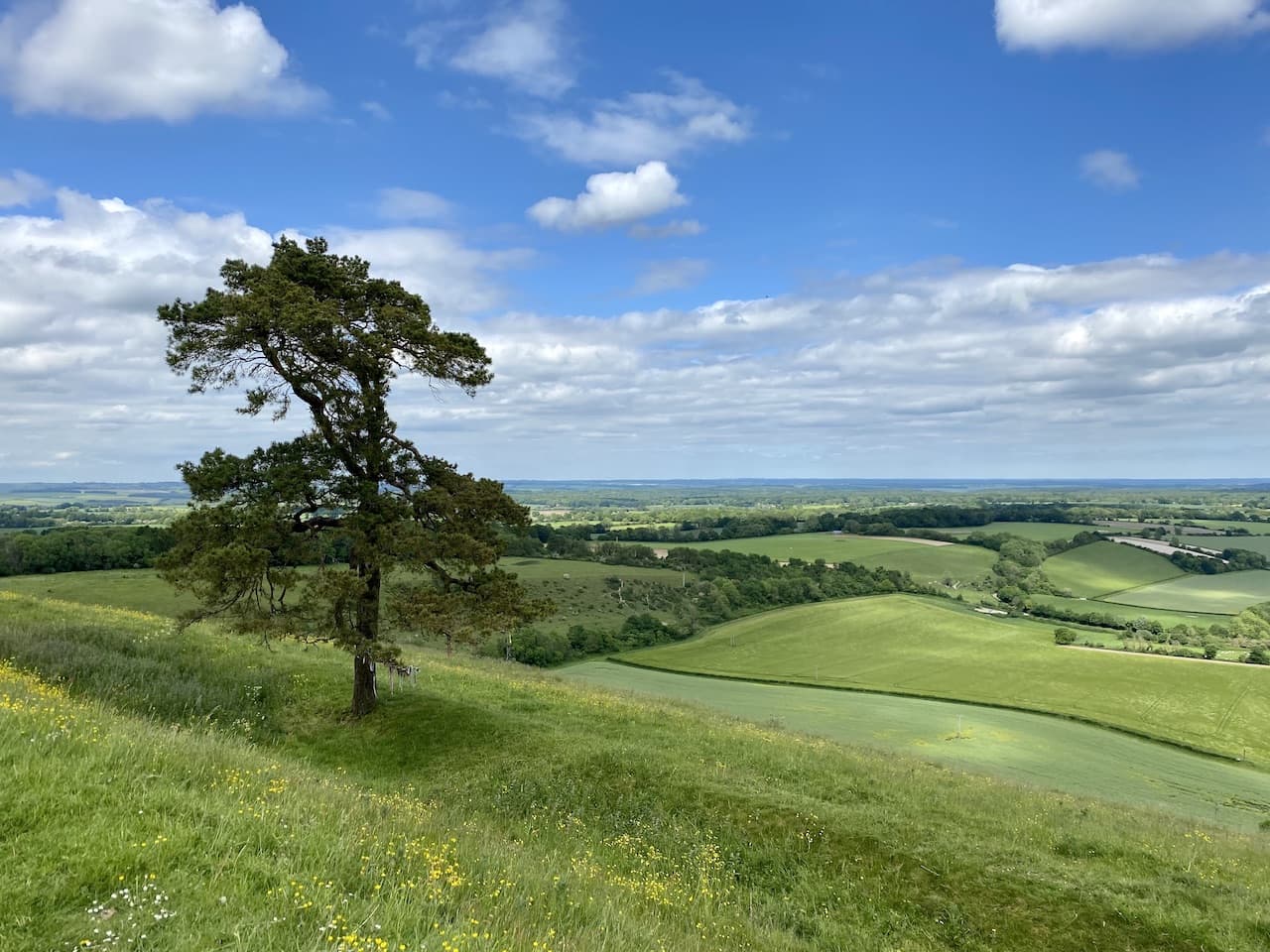
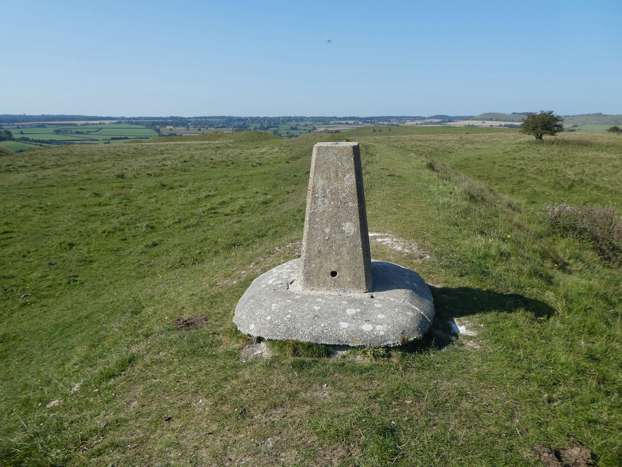
    We soon pass the access land around White Barrow and then at a fork in the path go to the right continuing up Copehill Down.  There are a network of military tracks on these downs, but our route is straightforward keeping with the way-markers for the Perimeter path.  On the summit of the Down we make a slight diversion by turning left to visit the Ordnance Survey Trig Pillar on Copehill Down, this is the  254th trig I have bagged.

    Back on the Perimeter path we continue across a junction of footpaths and then pass houses that have been built for training the military.

    Soon we head across another junction of paths and descend into the village of Chitterne.

    On entering the village we turn right along a minor road following the suggested new route of the Perimeter Path which avoids walking besides the B390.

    The lane we are on provides a good view of All Saints Church, parts of which date back to 1450 but most of it was rebuilt in the 1860’s.  We would normally make a diversion to visit the church, but we have a full day’s walking ahead of us so don’t want to delay our progress.

    At a junction of roads we turn left and then after a couple of hundred yards follow the way-markers on the right up a track running alongside old barns and then we keep going steadily uphill back onto the downs.  

    One of the benefits of walking a route like this is there are plenty of way-markers and we stick with these as the path goes over Breakheart Hill and then goes along a track at the boundary of the restricted area.

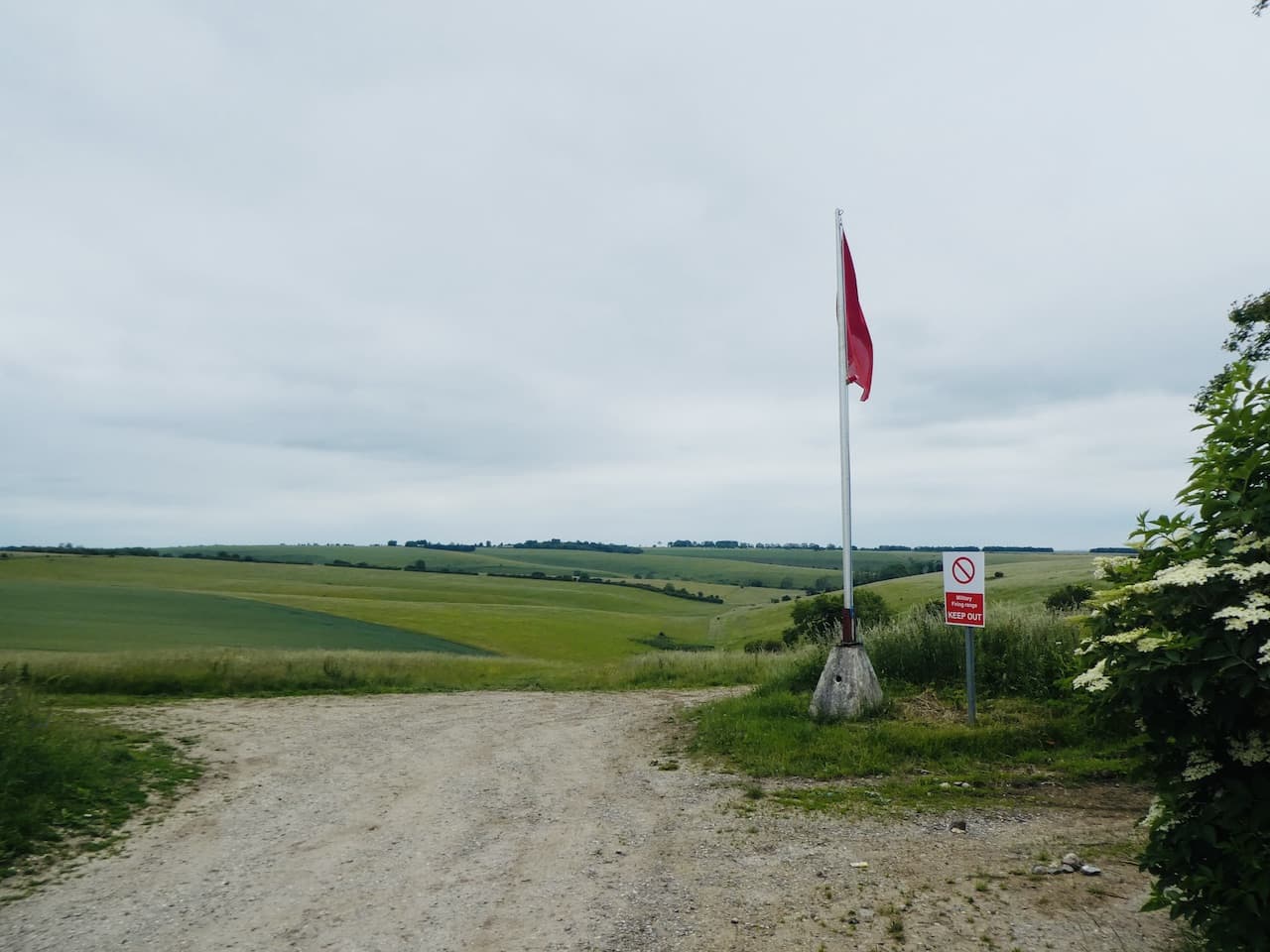
    Soon we pass Quebec Barn and at a junction of paths keep heading west.  To our right is the Knook Barrow OS trig pillar, it is one I have not bagged, but the red flags are flying on the range so it is not safe to visit.

    The path joins a well-made track and then bends to head downhill towards East Hill Farm.

    On reaching a minor road at East Hill Farm we turn left and follow the road heading towards Heytesbury.  Shortly before reaching Heytesbury House we go right on a path which goes steadily uphill to Cotley Hill Woods.

    After going through the trees we stay with the path over Cotley Hill.

    We are now walking along a ridge heading towards Scratchbury Hill on which sits the Iron Age hillfort of Scratchbury Camp.  After a gradual ascent we reach the camp and turn right to walk along the ramparts.

    After Scratchbury Hill we drop down to a track and then head over Middle Hill.

    Descending from Middle Hill the path leads to a track where we turn right and then soon left to start the steady ascent to the summit of the Battlesbury Hill.  This was the location of another Iron Age hillfort.  The 360 degree views from up here make it a good location for spotting enemies approaching.

    Rather than walk around the ramparts we follow a well-worn path towards the centre of the fort where there is an Ordnance Survey Trig Pillar, my 255th bagged.

    From the hillfort the way-markers direct us downhill to reach a minor road, Sack Hill, where we turn left and walk along the road, soon passing military barracks behind secure fencing.   After the barracks we turn right into Elm Hill and pass the modern St Giles Garrison Church.

    This is not the most attractive of places to walk but we know we will soon be back on the edge of the Plain.  We follow Elm Hill to a junction keeping with the way-markers and turning left to follow a rural lane downhill to the driveway of West Wilts Golf Club.   Our route turns right up the driveway and then forks to the right to follow a path besides a house before heading through trees to reach open countryside overlooking the wonderfully named Kidnappers Hole.

    Apparently this was the site of a chalk pit used in the lime kilns.  I have been unable to find out why it is called Kidnappers Hole, but in researching I did find reports of UFO sightings here in the 1960’s.

    To our left is the West Wilts Golf Course, this is a course I have never played and it is now so long since I last picked up my clubs, I doubt I ever will.

    As well as being the route of the Imber Range Perimeter Path, this is the route of the Wessex Ridgeway, a long distance path travelling 138 miles between Marlborough and Lyme Regis.

    At a junction of tracks we turn to the left and head north to stay with the Imber Range Perimeter Path.  There are cracking views in front of us and we can clearly see the path on the horizon a mile away.  There is a good stretch of downland walking before we get there.

    After passing a barn in a hollow we leave the track to go through a gate on the right following the Imber Range path signs.  The path drops into a hollow and then ascends steeply up a chalk escarpment.  It is a warm day so as we near the top we stop to admire the view behind looking back across where we were twenty minutes ago.

    After a kissing gate we turn right along a well-made track following the Imber Range Path signs.  The route has now joined the Mid Wilts Way, a sixty-eight mile long distance path crossing Wiltshire between the village of Ham, on the Berkshire border, and Mere on the Somerset border.

    We continue in a northerly direction passing a massive chalk quarry.  Permission for this quarry was granted following a ministerial decision in 1947, over the years it has expanded massively.  The chalk extracted fed the nearby cement works in Westbury.

    We pass the perimeter of the quarry and join a path besides the road leading to a car park.  As we proceed we get a good view of the Westbury White Horse.

    There are a group of paragliders on the edge of the escarpment waiting for the correct wind conditions to launch themselves off the side of the hill.  It is a pastime that would not suit me, I am far more comfortable with two feet on the ground.

    Near the car park we take a slight detour on a path to the left which has benches overlooking the valley.  This is a cracking spot for us to have lunch and the nearby toposcope provides details of the points we can see in the distance.

    Refreshed from lunch we return to the track and pass the car park and then turn right to reach the barns of White Horse Farm and then left along a wide stony track.

    We are now over twenty miles into our walk, but still have ten to do.  The track enables us to make good progress and there is no delay in identifying our route.  It is straightforward. We just keep the boundary of the range to our right.  As we head along there are some cracking views.

    The track leads to the entrance road to Imber village.  From the late 1800’s the War Office had been purchasing land on Salisbury Plain for military training.  By 1920 land close to Imber village was being purchased and farms around the village were gradually acquired for military use.

    On the 1st November 1943 the village residents were called to a meeting and informed they had 47 days to move out, the village was required for training for the Allied Invasion of mainland Europe.  All 150 villagers left their homes for what they thought was a temporary move.  Some even left tinned food in cupboards ready for their return.  Unfortunately, they were never allowed to return to their homes apart from a brief annual visit when the Ministry of Defence enables public access.

    Our route continues along a stony track, we are now getting a bit bored of walking on this surface.  It made a pleasant change earlier but is becoming tedious, but at least there are good views to distract us.

    The trail soon heads north towards Coulston Hill and then turns to the east leading us to the Ordnance Survey trig pillar on Stoke Hill, our third trig of the day and my 256th.

    Shortly after the trig we pass another area constructed for the military to practice urban warfare.

    The track heads towards the A360 and shortly before reaching the road we turn right just after passing barns and head south along another track until we reach a way-marker directing us left between fields.  It is good to be walking on grass again.

    At a junction of paths we turn right and follow the path across Lavington Down.

    On reaching a minor road we turn left and walk through trees to pass an impressive, brick water tower apparently this is all that remains of a military camp on this site.

    Emerging from the trees we see Tilshead below us, we have just a mile to do and are both relieved that it is downhill all the way.

    On entering the village we head back to the Rose and Crown and are soon sat in the bar rehydrating on beer.  After thirty-two miles the first does not touch the sides.  We are both pleased to have ticked off this walk, it has been on our list for a while and there is a good sense of achievement in completing it.  My walking app shows that our walking speed averaged 3.2 miles per hour which is not too shabby over such a long distance.

    You can view this 32 mile walk on OS Maps and download the GPX File Here

    To follow my walk, you will need Ordnance Survey Explorer Map -OS Explorer – 130 – Salisbury & Stonehenge; and OS Explorer – 143 – Warminster & Trowbridge

    24th June 2021

    © Two Dogs and an Awning (2021)

    All information on this site is provided free of charge and in good faith and no liability is accepted in respect of damage, loss or injury which might result from it.  To the best of my knowledge the routes are entirely on public rights of way or within areas that are open for public access.
    Walking can be hazardous and is done entirely at your own risk.  It is your responsibility to check your route and navigate using a map and compass.

  • Wootton Rivers and Martinsell Hill

    Wootton Rivers and Martinsell Hill

    Overgrown and poorly maintained footpaths marred our walk yesterday and I am not keen to repeat the experience so have planned a walk in an area I know will be hassle free.  It will combine a section of the Kennet and Avon Canal and also take us to the stunning Martinsell Hill.

    The starting point for our walk is the free car park in the centre of Pewsey off Goddard Road (Grid Ref: SU162601).  Leaving the car park we walk back to the A345 the main road through Pewsey and turn right by the Post Office and follow the road as it goes through the village and when it bends to the right we turn left into Church Lane.   

    We soon cross the River Avon and then follow a footpath skirting the grounds of Offices and follow this past Pewsey Vale football ground to reach Eastern Lane.  Here we turn right and then very soon reach Ball Lane where turn left into Ball Road and head north to reach a junction with a fine old lamp post and signpost. 

    Here we turn right and then very soon meet a mini roundabout where we turn left into Hollybush Lane.  We are on the route of the White Horse Trail and at a fork in the road go right where Hollybush Lane continues along a single track lane.  After going under a railway bridge we continue past cottages.  Here we stay with the White Horse Trail as it heads steadily downhill on a path leading towards a footbridge over the River Avon.

    After crossing the river we are very soon at Pains Bridge where we take the footpath on the right to join the towpath of the Kennet and Avon Canal.  We have walked many sections of this canal, but this is the first time on this section.

    It is a cracking afternoon to be walking along the canal and this is a very quiet length of towpath.  As we walk along we spot a World War II pillbox in a field on the opposite side of the canal.  This is one of a series of such boxes built along the edge of the canal to form the GHQ Blue Line a section of the General Headquarters Line which compartmentalised the Country to thwart the expected German Invasion.

    The next bridge we reach is the Milkhouse Water Bridge (No.112) which we pass under and continue on the towpath through the open countryside. 

    I enjoy walking on canal towpaths and find the engineering involved in constructing these waterways very interesting.  Lynnie is less keen, especially if we spend hours walking along them, however, she does enjoy walking along the level path with no hills to climb.  Although, I have planned a bit of that for later on.

    After around two miles on the towpath we reach Wootton Rivers Bridge and Lock.  Here we cross the bridge to walk into the village.

    It has turned into a very hot day and on reaching St Andrew’s Church we look for a bench in the shade to stop for lunch.  This church was rebuilt in 1860 and the steeple has a three faced clock which was built in 1911 to commemorate the coronation of King George V.

    Refreshed we resume our walk and continue through the village heading north to pass the Royal Oak pub.

    We leave the road at a fork to take a footpath along a track to the left of a thatched cottage.

    The track soon starts to head uphill between fields.

    On reaching the top of the track we turn right to take a footpath that skirts along the southern edge of the field.

    On joining another track we turn left to walk uphill to a junction with a tree lined track, Mud Lane, here we turn left and follow the lane along the top of the ridge.

    At this time of the year there is not much mud in Mud Lane, however, a couple of areas still remain a bit sticky so it is easy to see how it acquired it’s name.  We stay with the lane to reach a minor road and then cross to go through a car park to enter the open access land of Martinsell Hill.  

    This is a stunning spot and although we can wander anywhere we stay with the route of the Mid Wilts Way.  This 68-mile route crosses the County from the Berkshire border at Ham, near Hungerford and ends at Mere, close to the Dorset border.  It is a walk that I have thought about doing, but the pandemic has made planning it very difficult.  Hopefully in 2022 things will have eased and I will be able to fit it in.

    We stay with the route way-markers which take us around a copse and then along the top of the steep escarpment of the hill.  I have been here a few times, but still wonder at the stunning view.

    This is the third highest spot in Wiltshire and on the summit is an Iron Age hill fort with the ramparts still visible.

    We follow the path through a gate and pass a bench where a couple are admiring the view.  We have a brief conversation and continue on our way.  As we walk I say to Lynnie that I think I recognised one of the women on the bench but I can’t place where from.  Lynnie says she had the same feeling, it takes about ten minutes for us to realise it was a well known actress.  Respect for her privacy prevents me from naming her.

    We now go through the edge of woodland and then the path leads along the edge of a field heading towards a gate.

    Through the gate we continue along the ridge towards Giant’s Grave which is the site of an Iron Age Promontory Fort which resembles a long barrow.

    We pass through the ramparts of the fort to reach the Ordnance Survey trig pillar which is located on the opposite side of the fence.  I have bagged this trig a number of times but still admire the views from this cracking spot.

    It is now a steep descent from the hill along the fence line.  On our previous visits to Martinsell Hill we have walked up this route, but it is far easier on the lungs going down, but harder on the knees.  We go through a kissing gate and follow the well-worn path to reach another gate to join a track.  Here the Mid Wilts Way turns to the right to head towards Oare, but our route is straight over the track to follow the route of the White Horse Trail.

    On reaching Sunnyhill Lane we turn left and then after a couple of hundred yards take a track on the right that leads south towards the Kennet and Avon Canal and Pains Bridge.

    After crossing the bridge we continue along the path to cross the River Avon and then as we reach houses turn right to follow a footpath that soon runs besides the railway line and passes an old mill.

    We then join a minor road which soon goes under the railway line to reach the A345 where we turn left and follow the pavement down into the centre of Pewsey.  There are some interesting independent shops in the village and I am also fascinated by the Shed Alehouse.  It is closed, but I later discover that this is a small, basic pub serving ales and ciders from micro-breweries. It lists  an amazing number of beers it has served in the past.  Just the sort of place I would love to visit, but not when driving.

    Soon after passing the Shed Alehouse we reach the Post Office and turn right to return to our starting point.  I hope it won’t be too long before we get a chance to visit Martinsell Hill again.

    You can view this 11 mile walk on OS Maps and download the GPX File Here

    To follow my walk, you will need Ordnance Survey Explorer 157 – Marlborough & Savernake Forest

    9th June 2021

    © Two Dogs and an Awning (2021)

    All information on this site is provided free of charge and in good faith and no liability is accepted in respect of damage, loss or injury which might result from it.  To the best of my knowledge the routes are entirely on public rights of way or within areas that are open for public access.
    Walking can be hazardous and is done entirely at your own risk.  It is your responsibility to check your route and navigate using a map and compass.

  • A White Horse and Moonrakers

    A White Horse and Moonrakers

    At the start of the year my walking buddy Mandy suggested we try to visit all the Wiltshire White Horses in 2020.  Normally this would not be too difficult to organize, however the travel restrictions around the Covid pandemic has made it more challenging.  Today we are setting off to the Pewsey Vale to bag the Alton Barnes White Horse and in the process also visit Milk Hill the second highest point in Wiltshire.

    The starting point for our walk is the free car park at Walkers Hill besides the road between Alton Barnes and Lockridge (Grid Ref: SU116638).  Leaving the car park we cross the road and go through a gate and then immediately take a gate on our left and follow the path to reach another gate.  In front of us is Walkers Hill but we take a path that goes to the right and gradually ascends to get fine view across the Pewsey Vale.

    The path is clear and easy to follow and we soon get a great view of the Alton Barnes White Horse.  Originally there were thirteen White Horses in Wiltshire, but now only eight remain. This horse was first cut in 1812 when Robert Pile of Manor Farm in Alton Barnes paid twenty pounds to John Thorne, known as Jack the Painter, to design and cut the horse.  

    With the white horses at Pewsey, Devizes, Marlborough, Cherhill, Hackpen Hill, Broad Town and Westbury in the bag this one today completes the full set.  As we continue our walk on the path above the white horse we discuss which has been our favourite.  The most impressive is Westbury, but as that is now concrete we are not sure it really counts, on balance I favour Cherhill and we agree the most disappointing is Marlborough.

    We are following the route of the White Horse Trail and we stay with this as we head around the top of the downs enjoying stunning views.

    We are now on Milk Hill, the highest point in Wiltshire standing at 968 feet above sea level.  It is said to be 26 centimetres higher than its neighbour Tan Hill.  We stay with the White Horse Way until we reach a track where we turn left and then at a junction of paths continue heading west on a path that follows the impressive medieval earthworks.

    We stay with the path on the earthworks for just over a mile and then at a junction of paths turn left to follow a path heading south along the edge of a field.  The OS Map shows there is trig point just over the fence, but from research prior to setting out today I know that it has been moved to the south west corner of the field so we continue on the path until we reach a junction of fences and then take a brief detour to visit the relocated Tan Hill trig pillar.  

    This trig is the 232nd I have bagged.  It is disappointing it has been moved, but rather that than destroyed.  It is not the first I have come across that is not in its original location, but the views from here are still impressive and we can see the Cherhill Monument in the far distance.

    From the trig we head back to the path and follow this downhill through cattle to go through a gate to reach a junction of paths.

    We take the right fork following the path to meet a minor road at Cannings Cross Farm.  Here a notice states this is the site of the real Moonraker Pond.  Legend has it that in the 1780’s locals hid smuggled contraband in a pond to avoid the revenue men. Whilst retrieving it the revenue men arrived and the locals explained their activity by pointing to the moons reflection in the pond and saying they were trying to rake the big cheese from the pond. The revenue men laughed thinking them simple folk and went on their way.  The contraband was then retrieved.  This tale has led to people born in Wiltshire being known as Moonraker’s, a term that applies to both Mandy and I.  However, there are many ponds in Wiltshire claiming to have been the source of this tale and strangely there does not appear to be a pond marked on the map at Cross Cannings Farm.

    The footpath leads through the farm and then continues across fields.  To our right the map shows a long barrow so when we reach a track we turn right to make a slight detour to explore.  This is a modern Long Barrow built in 2014 to enable 340 people to have their ashes interned.  It has been aligned so that the sunrise of the winter solstice lights up the internal chamber.

    Returning to our route we go back along the track and then cross the Woodway Bridge over the Kennet and Avon Canal and immediately turn left to join the canal towpath.  Over recent years I have walked many sections of the canal, but this is new to me.  It appears a number of permanent barge dwellers are moored here.

    We stay with the towpath to pass under All Cannings Bridge (No.127) and continue on until we reach England’s Bridge (No.126).

    It is around lunchtime so we decide to leave the canal and cross the bridge to wander into Stanton St Bernard to visit the church and hopefully find a bench for lunch.  In the field beside the track we see a World War II pillbox.  This is one of the many pillboxes along the Kennet and Avon Canal and formed what was known as the Blue Line.  This was one of a number of “Stop Lines” that were established in the event of a German invasion during the war.

    We soon reach All Saints Church.  There was originally a church here in the 13th century which had a tower added in the 15th century.  In 1832 all the church apart from the tower was rebuilt.  As anticipated we find a bench in the churchyard which is an ideal spot to stop for our refreshments.

    The church is locked so we are unable to look inside.  It is not clear if it is locked due to concerns about Covid or for security.  Either way I find it odd that buildings traditionally providing people with a place for reflection and sanctuary are locked, especially at times when so many are struggling with the impact of the pandemic. We continue our walk and Mandy, who unlike me is a believer moans about the church hierarchy and its locked church policy.  I think a letter to the diocese will be winging its way soon after she returns home.

    Rather than retrace our steps to the canal we decide to walk through the village and rejoin it at Stanton Bridge.  This is straightforward and we keep right at every junction until we get to the canal where we rejoin the towpath heading east.  This soon leads us to the Barge Inn at Honeystreet.

    We now have over three miles on the canal towpath as it heads east.

    After two miles we reach the ornate Ladies Bridge built by John Rennie in 1808.  The design was at the behest of local land owner Susannah Wroughton and the reference to Ladies refers to her and her daughter, also named Susannah.

    Almost a mile from Ladies Bridge we reach Wilcot Bridge.  Here we leave the towpath to join a minor road running parallel to the canal.  After a few hundred yards the road bends to the left away from the canal and we start to head steadily uphill.  At a junction we go left and then almost immediately right.  Reaching a crossroads we go straight across on a road signposted to Huish and Draycot and soon reach Draycot Farm.

    The road bends to the north and we stay with it for a few hundred yards and then as it turns to the right we go straight on along a footpath into a field. After a second gate the path starts to steeply ascend Draycot Hill.

    At the top of the hill we go through a gate and join the Tan Hill Way and Mid Wilts Way heading west.  This is a cracking hill to walk along with numerous inlets with great contours.  They look spectacular on the map but even better when viewed from above.

    The path is well marked and passes through gates and by a large dew pond.  These ponds are a common feature on chalk downland.  They were dug out and lined with clay so they filled naturally with rainwater, thereby providing drinking water for the grazing livestock.  

    For the last couple of hours rain has threatened, now it arrives.  We are walking directly into the wind with no protection from the elements so we quickly don our full waterproofs.

    The route is now very straightforward, the well worn path leads us back to our starting point at the car park.  Despite the last half hour of rain our walk has been a cracking 15 mile route.  

    You can view this 15 mile walk on OS Maps and download the GPX File Here

    To follow our walk you will need Ordnance Survey Outdoor Explorer Map – 157 – Marlborough & Savernake Forest

    11th November 2020

    © Two Dogs and an Awning (2020)

    All information on this site is provided free of charge and in good faith and no liability is accepted in respect of damage, loss or injury which might result from it.  To the best of my knowledge the routes are entirely on public rights of way or within areas that are open for public access.
    Walking can be hazardous and is done entirely at your own risk.  It is your responsibility to check your route and navigate using a map and compass.

  • Castle Hill and White Sheet Hill

    Castle Hill and White Sheet Hill

    Over the last thirty years I have frequently travelled between Salisbury and Taunton and driven past Mere on the A303.  I can’t recall ever visiting the town and have often looked at the hill close to the main road which has flag pole on the top and wondered what remained of the castle that once stood there.  Wyndham Farm CL is only a couple of miles from Mere so today we are heading there to visit the castle and walk on White Sheet Hill.

    The starting point for our walk is the free car park in Castle Street (BA12 6JE) close to the centre of Mere.  Leaving the car park we turn left and then on reaching the first house after the car park we cross the road and take a footpath up an alley way between a house and a wall.  This leads to Castle Hill Lane which we cross and continue uphill on a path besides a children’s playground.

    After the playground we turn left and take a path leading to a gate into the castle site and then proceed heading west under the ramparts of the castle to reach the western end where we take a path leading steadily up to the summit.

    There is no trace of the castle that once stood here.  It was built in 1253 by Richard the Earl of Cornwall.  He was the brother of Henry III.  After Richard’s death his son Edmund inherited the castle but on his death it returned to the Crown. In the 14th century Edward III made the site part of the Duchy of Cornwall where it has remained. On top of the hill stands a Memorial to the 43rd (Wessex) Infantry Division.

    There are fine views from this spot and to help identify points on the horizon there is a toposcope. However, not all points are visible. As hard as we look we cannot spot John O’Groats which is apparently 530 miles away.

    From the summit of the hill we descend by the route we came up and then head west along a path that follows the ridge of Long Hill.  A herd of goats appear beside the path, some take umbrage that we are walking through their territory and are reluctant to let us pass along the track.

    The route descends to a gate where we turn right and join a track that soon reaches a bridge across the A303 and then continues along the edge of a field.

    We stay with this track as it heads  through fields towards Search Farm.  There are fine views of White Sheet Hill to our right and it looks like it is going to be a good ascent to reach the top later.

    After passing Search Farm we reach a junction of tracks where we turn right on a tree lined path.

    This path leads us to Beech Clump where, besides the path, is a memorial dedicated to the crew of Dakota III TS436.  On 19th February 1945 this plane took off from the nearby wartime airfield at RAF Zeals with a crew of airmen heading back to their base in Leicester.  In low patchy cloud the pilot failed to gain enough height  and hit the trees on Beech Clump.  As a result the plane burst into flames and the lives of twenty airmen were lost.  The only survivor was the pilot.

    Apart from the memorial there is no indication now of the tragedy that occurred in this clump of trees.

    We continue along the track to reach a parking area and then at a fork in the path follow a route that gradually ascends the ridge.  

    Heading upwards we enjoy the cracking views of the chalk escarpment of White Sheet Hill.

    The path leads us to the top of the hill where we spot the remains of an old metal fence post.

    Our route is to the right but first we go left across the access line to reach the fence line so that we can view the old milestone that sits beside the Drove which is known as the London Road.  The inscription reads XXIII Miles from Sarum 1750.  Below the inscription there is an Ordnance Survey cut benchmark which would have been used as part of a mapping survey of this area.

    We now head back to the metal fence post and follow a path heading south east along the top of the escarpment.  On reaching the ramparts of White Sheet Castle we turn left and walk up to the Ordnance Survey trig point on the summit of White Sheet Hill, this is the 218th I have “bagged”.

    White Sheet Castle was an Iron Age Hillfort and much of the site is preserved so it is easy to imagine the scale of the fort. Being some distance from the nearest car park it is amazingly quiet and despite it being a stunning day we can only see two other people enjoying the views.

    From the trig we head south east to reach a fence line and follow this north to a gate entering another access area.  Here we turn left and follow the fence line back up to a gate besides a covered reservoir.  We cross the track and take a footpath heading diagonally across a field to reach anther track where we turn left and then besides cattle pens enter a field on the right.  We head northwesterly across this field following the contours around the top of a valley.

    The path then heads north across White Sheet Down.  There are stunning views as we continue along the top of the downs and then start to descend to a gate which leads to a track.

    Joining the footpath along the track we pass through the yard of Coombe Barn farm and continue to a junction of tracks where we turn right.  Soon we enter a field  and continue through a second field to reach the farm driveway to Rodmead Farm.  

    We turn right along this track following the footpath as it skirts around Rodmead Farm with its attractive barns.

    At a fork in the track we go right and start a long steady ascent up the side of the escarpment passing Rodmead Wood and continue on until we reach a junction with the Mid Wilts Way (MWW) long distance trail. 

    Now we turn right and go through a gate and follow the route of the MWW as it follows the fence line above the attractive valley.

    On reaching a track we cross and continue on the MWW through a field of pasture.  This is access land but we stick to the route of the path until we reach a fine stone bench erected by the Mere Footpath Group.

    Just after the bench we leave the Mid Wilts Way by forking right on a track heading steadily downhill.

    As we descend there are cracking views of the escarpment of White Sheet Hill.

    The track leads to a lane, Manor Road, where we turn left and follow this lane to pass Manor Farm and then take the bridge over the A303.  Now we continue on the road into the centre of Mere close to the Clock Tower.  Apparently this was built in 1868 and was given to the town by Albert the Prince of Wales.

    From here we take Castle Road passing the George Inn and the fine Old Ship Hotel.  Unfortunately the Ship is permanently closed and looks in need of a full renovation.  The stunning building dates from 1711 and is Grade II listed because of its many fine external and internal features.  Castle Street, on which the pub stands, was once the main Exeter to London route so this would have been an important staging point.

    It is sad to see such fine old buildings no longer in use as pubs.  Hopefully, someone will buy it and re-open it as a hotel again.  We now continue along Castle Street to our starting point at the Castle Street car park.

    Our walk has covered nine miles and we have been treated to some stunning views.  It is a walk we hope to do again before too long.

    You can view this 8.6 mile walk on OS Maps and download the GPX File Here

    To follow my walk you will need Ordnance Survey Explorer Map 143 Warminster & Trowbridge and 142 Shepton Mallet & Mendip Hills East.

    21st September 2020

    © Two Dogs and an Awning (2020)

    All information on this site is provided free of charge and in good faith and no liability is accepted in respect of damage, loss or injury which might result from it.  To the best of my knowledge the routes are entirely on public rights of way or within areas that are open for public access.
    Walking can be hazardous and is done entirely at your own risk.  It is your responsibility to check your route and navigate using a map and compass.

  • Walkers Hill from Pewsey

    Walkers Hill from Pewsey

    Last year with  three walking buddies I walked the Sarsen Trail, the 26-mile walk between Avebury and Stonehenge.  The route took us over Walkers Hill near the Alton Barnes White Horse and the views were absolutely stunning.  Today Lynnie and I are going there, we could start our walk from the car park on Walkers Hill, but I always think part of the enjoyment of visiting somewhere is the journey involved so we are starting nine miles away in Pewsey.

    We park in the free car park in the centre of Pewsey, off Goddard Road (Grid Ref: SU162601).  Leaving the car park we walk back to the A345 the main road through Pewsey.  We turn left and follow the road to a mini roundabout then continue besides the A345, now North Street.  We stay on the main road until we reach Buckleaze Lane on the right.  This lane goes under a railway bridge and then turns right to run parallel to the line before becoming a footpath besides an old mill.

    After crossing the River Avon we continue on the narrow path besides the railway line, when the path opens out we fork left keeping a fence on our left and soon pass gardens.  Reaching a tarmac lane we continue to a junction and turn left to head north on a bridleway, this is the route of the White Horse Trail. The path heads downhill and crosses the River Avon.

    Soon after we cross the Kennet and Avon Canal at Pains Bridge. 

    The path is now a farm track still heading north.  After passing the entrance to Inlands Farm we continue on the farm track. 

    Reaching a minor road, Sunnyhill Lane, we turn left and then soon turn right to pick up the White Horse Trail again until we reach a track.  Here we leave the White Horse Trail and turn left along the track, we are now on the route of the Mid Wilts Way.  This long distance path is a 68-mile route crossing the County from its boundary with Berkshire to Somerset.  We follow the lane, Pound Lane into the village of Oare.

    Reaching the A345 we turn right and pass The White Hart pub, sadly this pub closed in 2014 and it looks like it is a long way from re-opening.  Such pubs are key to retaining village life and it is surprising that one so close to so many good walks is not worthy of brewery investment to keep it going.  Apparently the local community had plans to try and operate the pub as a community venture, but that doesn’t seem to have progressed.

    Soon after passing the pub we take a lane on the left leading past the school and then turn right to follow a footpath heading steadily uphill on the edge of a field. We are still on the Mid Wilts Way. 

    The path enters access land on Huish Hill and then climbs steeply.  It is a hot day and this ascent is a good challenge but the views make it worthwhile.

    We follow the footpath to reach a driveway to Huish Hill House and then turn left to follow the path through the grounds of the property and into a copse.  The path now continues in a northwesterly direction across fields.

    We have now joined the White Horse Trail and Tan Hill Way; the latter is a 12-mile route from Clench Common to the Wansdyke Path.  I often wonder how walks such as this end up being named on the Ordnance Survey Map. 

    We stay with this route to reach a gate leading into a field of cattle.  I am wary of cattle, especially when Crosby is with me, there is something about him that seems to attract them.  This herd are in a frisky mood so we make a quick decision to re-plot our route.   Back at the gate we turn and follow a footpath along a grassy track heading east.

    In just under a mile we take a footpath on the left to head north towards Bayardo Farm. After passing farm buildings the track takes us to the farmhouse with a Caravan and Motorhome Club CL in the field to our right.

    We turn left and briefly follow a road, but as this sweeps sharply to the right we continue straight on along a track into Broom Copse.

    This is a cracking bit of woodland.  We stay with the track along the southern edge of the woods.

    At a junction of tracks we turn left and continue along the edge of trees now on the route of the Wansdyke and White Horse Trail, this passes Strawberry Ground and Heath Plantation to reach another crossing of paths.  We go left following the White Horse Trail way-markers south.

    The track reaches a junction of seven footpaths, we turn right into a field and head steadily uphill besides Gopher Wood to reach the top of Draycott Hill.

    We now head west along the top of the hill.  The views from here are stunning.

    A few times this year Lynnie has asked why we have not walked more in Wiltshire, she had not appreciated it was so beautiful.  The answer if that we usually head off to walk in the Yorkshire Dales, Scotland, Exmoor or the Brecon Beacons, but the views from here compare with anywhere we have been on our travels.

    The path passes through fields abundant with a wide array of wildflowers.  Despite all the challenges of the year so far being here surrounded by nature is great therapy.

    Our route descends to skirt north of the Neolithic hill fort on Knap Hill.

    We then continues through a car park.  We cross the road and turn to the left to follow a path up Walkers Hill.

    The views from the top are panoramic. 

    It is a clear day and we can see for miles.

    We head south down Walkers Hill getting a good view of the Alton Barnes White Horse.  This horse was first cut in 1812 when Robert Pile of Manor Farm in Alton Barnes paid twenty pounds to John Thorne, known as Jack the Painter, to design and cut the horse.  The figure stands on Milk Hill which is the highest hill in Wiltshire at 295metres and is reported to be the second highest chalk hill in the UK.

    On the 10th May 2011 a chap named Neville Almond recorded the longest hang gliding flight in the UK after taking off from Milk Hill.  He flew an amazing 167 miles to the Norfolk coast in less than five hours.  His record stood for a year until Carl Wallbank flew from Llangollen in Wales to Weymouth a distance of 171 miles.

    After going through a gate we continue downhill crossing the road and joining a permissive path besides paddocks.  As we near a road we turn left and follow the path along the edge of the field and then join the road and soon turn right by a fine old thatched barn in Alton Priors.

    At the back of the barn I spot a collection of old farm machinery and we wander over to have a look.

    Resuming our walk down the lane in front of the barn we see that it is full of old farm machinery.  I particularly like the seed drill.  When I was a nipper working on a farm I used to ride on the back of one of these to make sure the seed was distributed evenly.

    Now we continue down the lane, Village Street, and follow this to a gate with an interesting turnstile besides it.

    We enter the field and walk the short distance to All Saints church.  This church dates from the 12th century but it was declared redundant by the Church of England in 1972 and is now in the care of the Churches Conservation Trust.  

    It is used as a meeting place, but retains the feel of a place of worship.

    In the churchyard there is a Yew Tree which has been dated as 1,700 years old.  Faced with a tree with a hole in it Lynnie belies her years and cannot resist sticking her head through it!

    From the church we follow the footpath to another set of turnstiles on either side of a footbridge.

    From here we follow the paved footpath across a field of pasture and head towards St Mary’s Church in Alton Barnes.  

    The two churches are only a few hundred yards apart.  It would appear that the two congregations of Alton Barnes and Alton Priors were separated in 1660.  I had hoped this church would be open, when I walked by here last summer restoration work was in progress and we managed a brief peek inside and it was full of scaffolding, however a notice on the door says the church has been permanently closed.

    From the church we head along the lane to reach a minor road where we turn left and follow it into Honeystreet where we join the towpath of the Kennet and Avon Canal and head east.

    We walk along the towpath for four and a half miles, it is a cracking section of the canal going through open countryside with the occasional barge moored on the bank.  

    We pass under the ornate Ladies Bridge, built by John Rennie in 1808.  The design was at the insistence of Susannah Wroughton who owned the land the canal passed through and the name refers to her and her daughter, also Susannah.

    Just after the bridge we reach a section where the canal widens, this was also at the behest of Susannah Wroughton and her family, they would only allow the canal to pass through if an ornamental lake was created.

    From here we pass Wilcot bridge and then go under the Stowell Park suspension bridge which spans the canal.  This was built in 1845 as a bridge for a private path across the canal. It was designed and built by the noted bridge builder James Dredge (senior).  Apparently he was a brewer who later became an inventor of suspension bridges unfortunately only a few now remain. 

    We continue on, passing Pewsey Wharf, now the location for the Waterfront a pub and cafe but in the past it would have been key to local trade with goods being loaded and unloaded.  There are a few people about so conscious of the need to social distance we decide to keep going and not explore the site.

    Staying on the towpath we pass more barges, these look like they are permenantly moored.  We soon reach Pains Bridge where we leave the canal and turn right to retrace our earlier route back towards Pewsey.  As we reach houses we have the option of following our earlier route back to the car or continuing along Hollybush Lane.  We opt for the latter and take this lane along the edge of the village.  We stay with this road as it becomes more built up and then at a junction with the B3087 turn right and soon reach a guide post with a lamp at the junction with Ball Road.  The base and cast iron post date from 1880 with the lamp being added later.

    We stay with the B3087 and walk along the pavement to reach the centre of Pewsey where we turn right at the statue of King Alfred and return to our starting point.  Our walk has covered close to 16.5 miles and has had some absolutely stunning views.  

    We are heading home tomorrow.  Our first trip away since the outbreak of the Covid-19 pandemic has been really enjoyable and there have been times when we have forgotten about all the challenges going on in the world.  Hopefully it won’t be too long before we are off in the Coachman again.

    To follow this walk you will need Ordnance Survey Explorer Map OL157 Marlborough & Savernake Forest

    You can view this 16.5 mile walk on OS Maps and download the GPX File Here

    16th July 2020

    © Two Dogs and an Awning (2020)

    ll information on this site is provided free of charge and in good faith and no liability is accepted in respect of damage, loss or injury which might result from it.  To the best of my knowledge the routes are entirely on public rights of way or within areas that are open for public access.
    Walking can be hazardous and is done entirely at your own risk.  It is your responsibility to check your route and navigate using a map and compass.

  • Martinsell Hill and Milton Hill

    Martinsell Hill and Milton Hill

    Back in May I walked from Pewsey and visited Martinsell Hill and the Pewsey White Horse.  The views were stunning and on showing the pictures to Lynnie she said she would like to walk there.  We are staying very close to Pewsey and the weather looks set fair for the day so it seems a good time to head there.

    Our starting point is the free car park in the centre of Pewsey, off Goddard Road (Grid Ref: SU162601).  Leaving the car park we walk back to the A345 the main road through Pewsey.  We turn left and follow this road, at a mini roundabout we continue besides the A345, now North Street.  We stay on the main road until we reach Buckleaze Lane on the right.  This lane goes under a railway bridge and then turns right to run parallel to the line before becoming a footpath besides an old mill.

    After crossing the River Avon we continue on the narrow path besides the railway line, when the path opens out we fork left keeping a fence on our left, soon passing gardens.  Reaching a tarmac lane we continue to a junction and turn left to head north on a bridleway, this is the route of the White Horse Trail.

    The path heads downhill and crosses the River Avon. Soon after we cross the Kennet and Avon Canal at Pains Bridge. 

    The path is now a farm track still heading north.  After passing the entrance to Inlands Farm we take a footpath on the left which crosses a stile into a field. 

    In a second field we continue on the well-worn path to cross a minor road, Sunnyhill Lane remaining on the White Horse Trail.  In the distance in front of us is the hill we will soon be ascending to reach Giants Grave.

    At a junction of tracks we turn left to head along the northern edge of a field towards woodland.  

    The path follows around the woods to reach the A345 where we turn right and walk a few hundred yards to reach Holy Trinity Church in Oare.  This is a fairly modern church, built in 1858 and has an interesting design.

    From the church we take a gate and head west to reach Rudge Lane, where we turn right and pass Oare House.  This is a fine Grade 1 listed building built in 1740 for a London wine merchant.  Apparently it was redesigned in the 1920’s by Sir Bertram Clough Williams-Ellis the architect best known for creating the village of Portmeirion in North Wales.

    We stay with the lane as it turns to the right to head back towards the A345 which we cross and join Pound Lane and follow it for quarter of a mile to a junction with the White Horse Trail footpath.  Here we turn left through a kissing gate then head across a field of pasture to reach another kissing gate. The path now climbs steeply.  It is a stiff ascent, but the views across the Vale of Pewsey are stunning.

    Near the summit we see an Ordnance Survey rivet in a solid concrete block.  

    A little further on just over a fence is an Ordnance Survey trig point, I have previously bagged this one but it is Lynnie’s first time here.

    The path now follows the fence line and passes through the promontory hill fort known as Giant’s Grave.

    The White Horse trail continues along the ridge.  After passing through a gate we continue following the way-markers.  At a fork in the path we go right leaving the White Horse Trail to join the Mid Wilts Way.  This runs along the edge of a field of pasture and then joins a path into woodland. We are now on Martinsell Hill and emerging from the trees we have stunning views.

    We go through a gate and stop to look at a tree with ribbons tied on it as a memorial to lost loved ones.

    Continuing along the top of the hill we stay with the way-markers for the Mid Wilts Way to pass around a copse and then at a junction of footpaths go right in an easterly direction, still on the Mid Wilts Way. 

    Turning around we get some stunning views of this impressive hill.

    The path continues to a car park and after crossing a minor road joins Mud Lane. 

    We stay with this track for two miles heading east.  There are paths leading off to the left and right, nearing a minor road we walk besides the route of the disused Midland and South Western Junction Railway.  This section linked Marlborough to Swindon and was completed in 1883, it closed to passengers in 1961 and freight in 1970.  

    At the minor road we turn right and gradually descend downhill until we reach a driveway on our left to Brimslade.  This tarmac drive continues steadily downhill to cross the Kennet and Avon Canal at Cadley Lock. 

    Now we turn right and follow the canal towpath heading west.

    We stay with the towpath for almost a mile to reach a lock at Wootton Rivers.  

    After passing the lock keepers cottage we leave the canal and join a minor road where we turn left and soon go over the railway line at a bridge and then turn right at a road junction and take the road to Milton Lilbourne.  

    We follow this minor road through a hamlet, Cuckoo’s Knob.  Soon we cross a stream and then as the road bends to the right we follow a footpath along a track heading south.

    We stay with this track for just over half a mile to reach the B3087, Burbage Road, at the Bruce Arms pub.

    We cross the road a join a footpath on the opposite side and continue to head south.  This is fairly level walking through the Vale of Pewsey but I know we will soon be ascending steeply. 

    The path leads to a minor road and we continue uphill on the road. 

    This is a steady ascent; a couple of times we think we are near the top and then see there is more “up” to do.  Eventually the road peters out at a junction of tracks besides the hard to spot remains of an old pump house.  We turn right and go south west to a junction of paths where we turn right and head west to Milton Hill Clump.  The map does not show this as a footpath but it is a well-worn route so we assume it is a permissive path.

    We stay with this path passing Milton Hill Clump and reach access land on Fyfield Down. After going through the gate we turn left to head along the top of the downs, soon passing Giants Grave long barrow.

    We continue along the ridge, enjoying stunning views across the vale, to reach Victory Clump.  The path now descends gradually down Pewsey Hill to reach a crossing of paths.

    Going over a stile we follow a path along the foot of Pewsey Hill until we are below the Pewsey White Horse chalk carving.  The Pewsey White Horse dates back to 1937 when it was cut to commemorate the coronation of King George VI.  There was an older white horse close to this site which was cut in 1785, but by the mid 1800’s it was said to be in bad repair.  I had planned we walk up to the horse, but it is soon very clear that Lynnie is content to view it from here and is definitely not being persuaded otherwise.

    We turn right along a footpath to reach a gate and then carry on along a track, Green Drove, until we reach a minor road where we turn right and follow this lane past farm buildings.  At the end of the lane we turn left along Southcott Road which we follow for just over quarter of a mile and then turn left by some cottages to follow a path along a lane which leads us back to the centre of Pewsey.

    Here there is a statue of King Alfred, crowned King of Wessex in 870 his land included the Vale of Pewsey.  Apparently whilst he was at war the local inhabitants cared for his wife he rewarded them by granting the inhabitants the rights to a feast, this has been incorporated into the modern day carnival celebrations.  The statue was unveiled in June 1913 to commemorate the coronation of King George V.  

    We continue along the High Street to reach the post office and return to our starting point.

    Our walk has covered 15 miles through some stunning scenery. 

    To follow my walk, you will need Ordnance Survey Explorer Map OL157 Marlborough & Savernake Forest; OL131 Romsey, Andover & Test Valley; OL130 – Salisbury and Stonehenge

    You can view this 15 mile walk on OS Maps and download the GPX File Here (Subscription to OS Maps Required)

    14th July 2020

    © Two Dogs and an Awning (2020)