Tag: Martinsell Hill

  • Wootton Rivers and Martinsell Hill

    Wootton Rivers and Martinsell Hill

    Overgrown and poorly maintained footpaths marred our walk yesterday and I am not keen to repeat the experience so have planned a walk in an area I know will be hassle free.  It will combine a section of the Kennet and Avon Canal and also take us to the stunning Martinsell Hill.

    The starting point for our walk is the free car park in the centre of Pewsey off Goddard Road (Grid Ref: SU162601).  Leaving the car park we walk back to the A345 the main road through Pewsey and turn right by the Post Office and follow the road as it goes through the village and when it bends to the right we turn left into Church Lane.   

    We soon cross the River Avon and then follow a footpath skirting the grounds of Offices and follow this past Pewsey Vale football ground to reach Eastern Lane.  Here we turn right and then very soon reach Ball Lane where turn left into Ball Road and head north to reach a junction with a fine old lamp post and signpost. 

    Here we turn right and then very soon meet a mini roundabout where we turn left into Hollybush Lane.  We are on the route of the White Horse Trail and at a fork in the road go right where Hollybush Lane continues along a single track lane.  After going under a railway bridge we continue past cottages.  Here we stay with the White Horse Trail as it heads steadily downhill on a path leading towards a footbridge over the River Avon.

    After crossing the river we are very soon at Pains Bridge where we take the footpath on the right to join the towpath of the Kennet and Avon Canal.  We have walked many sections of this canal, but this is the first time on this section.

    It is a cracking afternoon to be walking along the canal and this is a very quiet length of towpath.  As we walk along we spot a World War II pillbox in a field on the opposite side of the canal.  This is one of a series of such boxes built along the edge of the canal to form the GHQ Blue Line a section of the General Headquarters Line which compartmentalised the Country to thwart the expected German Invasion.

    The next bridge we reach is the Milkhouse Water Bridge (No.112) which we pass under and continue on the towpath through the open countryside. 

    I enjoy walking on canal towpaths and find the engineering involved in constructing these waterways very interesting.  Lynnie is less keen, especially if we spend hours walking along them, however, she does enjoy walking along the level path with no hills to climb.  Although, I have planned a bit of that for later on.

    After around two miles on the towpath we reach Wootton Rivers Bridge and Lock.  Here we cross the bridge to walk into the village.

    It has turned into a very hot day and on reaching St Andrew’s Church we look for a bench in the shade to stop for lunch.  This church was rebuilt in 1860 and the steeple has a three faced clock which was built in 1911 to commemorate the coronation of King George V.

    Refreshed we resume our walk and continue through the village heading north to pass the Royal Oak pub.

    We leave the road at a fork to take a footpath along a track to the left of a thatched cottage.

    The track soon starts to head uphill between fields.

    On reaching the top of the track we turn right to take a footpath that skirts along the southern edge of the field.

    On joining another track we turn left to walk uphill to a junction with a tree lined track, Mud Lane, here we turn left and follow the lane along the top of the ridge.

    At this time of the year there is not much mud in Mud Lane, however, a couple of areas still remain a bit sticky so it is easy to see how it acquired it’s name.  We stay with the lane to reach a minor road and then cross to go through a car park to enter the open access land of Martinsell Hill.  

    This is a stunning spot and although we can wander anywhere we stay with the route of the Mid Wilts Way.  This 68-mile route crosses the County from the Berkshire border at Ham, near Hungerford and ends at Mere, close to the Dorset border.  It is a walk that I have thought about doing, but the pandemic has made planning it very difficult.  Hopefully in 2022 things will have eased and I will be able to fit it in.

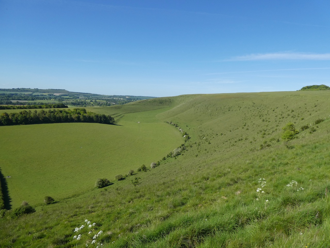
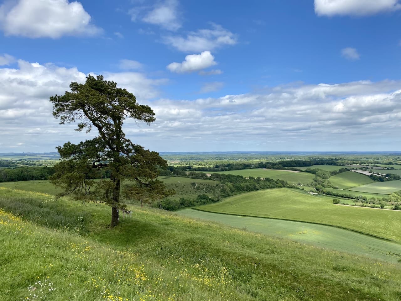
    We stay with the route way-markers which take us around a copse and then along the top of the steep escarpment of the hill.  I have been here a few times, but still wonder at the stunning view.

    This is the third highest spot in Wiltshire and on the summit is an Iron Age hill fort with the ramparts still visible.

    We follow the path through a gate and pass a bench where a couple are admiring the view.  We have a brief conversation and continue on our way.  As we walk I say to Lynnie that I think I recognised one of the women on the bench but I can’t place where from.  Lynnie says she had the same feeling, it takes about ten minutes for us to realise it was a well known actress.  Respect for her privacy prevents me from naming her.

    We now go through the edge of woodland and then the path leads along the edge of a field heading towards a gate.

    Through the gate we continue along the ridge towards Giant’s Grave which is the site of an Iron Age Promontory Fort which resembles a long barrow.

    We pass through the ramparts of the fort to reach the Ordnance Survey trig pillar which is located on the opposite side of the fence.  I have bagged this trig a number of times but still admire the views from this cracking spot.

    It is now a steep descent from the hill along the fence line.  On our previous visits to Martinsell Hill we have walked up this route, but it is far easier on the lungs going down, but harder on the knees.  We go through a kissing gate and follow the well-worn path to reach another gate to join a track.  Here the Mid Wilts Way turns to the right to head towards Oare, but our route is straight over the track to follow the route of the White Horse Trail.

    On reaching Sunnyhill Lane we turn left and then after a couple of hundred yards take a track on the right that leads south towards the Kennet and Avon Canal and Pains Bridge.

    After crossing the bridge we continue along the path to cross the River Avon and then as we reach houses turn right to follow a footpath that soon runs besides the railway line and passes an old mill.

    We then join a minor road which soon goes under the railway line to reach the A345 where we turn left and follow the pavement down into the centre of Pewsey.  There are some interesting independent shops in the village and I am also fascinated by the Shed Alehouse.  It is closed, but I later discover that this is a small, basic pub serving ales and ciders from micro-breweries. It lists  an amazing number of beers it has served in the past.  Just the sort of place I would love to visit, but not when driving.

    Soon after passing the Shed Alehouse we reach the Post Office and turn right to return to our starting point.  I hope it won’t be too long before we get a chance to visit Martinsell Hill again.

    You can view this 11 mile walk on OS Maps and download the GPX File Here

    To follow my walk, you will need Ordnance Survey Explorer 157 – Marlborough & Savernake Forest

    9th June 2021

    © Two Dogs and an Awning (2021)

    All information on this site is provided free of charge and in good faith and no liability is accepted in respect of damage, loss or injury which might result from it.  To the best of my knowledge the routes are entirely on public rights of way or within areas that are open for public access.
    Walking can be hazardous and is done entirely at your own risk.  It is your responsibility to check your route and navigate using a map and compass.

  • Three OS Trigs and The Pewsey White Horse

    Three OS Trigs and The Pewsey White Horse

    Now that the lock down restrictions have been lifted I am starting to undertake some walks a bit further from home.  I am not driving far, but within twenty miles of home there are numerous places I haven’t walked.  Earlier in the year I made plans with my walking buddy Mandy to visit all the Wiltshire White Horses in 2020.  We ticked off Cherhill and Devizes before the lockdown and today plan to “bag” the Pewsey White Horse.

    Despite living very close to Mandy we drive in separate cars to our starting point in the free car park in the centre of Pewsey, off Goddard Road (Grid Ref: SU162601).  Leaving the car park we walk back to the A345 the main road through Pewsey.  We turn left and follow this road, at a mini roundabout we continue besides the A345, now North Street.  We stay on the main road until we reach Buckleaze Lane on the right.  This lane goes under a railway bridge and then turns right to run parallel to the lane before becoming a footpath besides an old mill.

    After crossing the River Avon we continue on the narrow path besides the railway line, when the path opens out we fork left keeping a fence on our left and soon pass gardens.  Reaching a tarmac lane we continue to a junction and turn left to head north on a bridleway, this is the route of the White Horse Trail. The path heads downhill and crosses the River Avon.

    Soon after we cross the Kennett and Avon Canal at Pains Bridge.  The path is now a farm track still heading north.  After passing the entrance to Inlands Farm we take a footpath on the left which crosses a stile into a field. In a second field we continue on the well-worn path to cross a minor road, Sunnyhill Lane remaining on the White Horse Trail.  In the distance in front of us is the hill we will soon be ascending to reach Giants Grave.

    We cross a track and go through a kissing gate then head across a field of pasture to reach another kissing gate. The path now climbs steeply.  This is a stiff ascent, but the views across the Vale of Pewsey are stunning. Near the summit we see an Ordnance Survey rivet in a solid concrete block.  

    A little further on just over a fence is an Ordnance Survey trig point, this is the 202nd I have bagged.

    The path now follows the fence line and passes through the promontory hill fort known as Giants Grave.

    The White Horse trail continues along the ridge.  After passing through a gate we continue following the way markers.  At a fork in the path we go right leaving the White Horse Trail to join the Mid Wilts Way.  This runs along the edge of a field of pasture and then joins a path into woodland.

    We are now on Martinsell Hill and emerging from the trees we have stunning views.

    After going through a gate we make a brief diversion into the woodland on the left to reach my 203rd Ordnance Survey trig point.

    Continuing along the top of the hill we stay with the way markers for the Mid Wilts Way to pass around a copse and then at a junction of footpaths go right in an easterly direction, still on the Mid Wilts Way.  Turning around we get some stunning views of this impressive hill.

    The path continues to a car park and after crossing a minor road joins Mud Lane.  The first fifty yards along this lane demonstrates why it is so named, but then thankfully the ground becomes firmer.

    We stay with this track for two miles heading east.  There are paths leading off to the left and right, nearing a minor road we walk besides the route of the disused Midland and South Western Junction Railway.  This section linked Marlborough to Swindon and was completed in 1883, it closed to passengers in 1961 and freight in 1970.  At the minor road we turn right and gradually descend downhill until we reach a driveway on our left to Brimslade.  This tarmac drive continues steadily downhill to cross the Kennet and Avon Canal.  After crossing the canal bridge we turn left on the towpath to immediately pass Cadley Lock. 

    This is a section of the Kennet & Avon I have not walked and we are soon at the attractive Burbage Wharf.  This wharf was built in 1831 by the Earl of Ailesbury who owned Savernake Forest.  The wharf was a key point for loading and unloading barges with timber, coal and farm produce.  To enable this a large wooden crane was built. In 1970 it was discovered that the crane was unsafe and needed replacement.  The original ironwork was saved and the wood replaced to recreate the original.

    I have passed the wharf numerous times on the road, but this is the first time that I have been able to really appreciate the buildings.  We continue along the towpath and find ourselves at the western end of the Bruce Tunnel.

    Construction on this 502 yard tunnel started in 1803 and was completed in 1809.  It stands at the highest point on the canal.  It is named after the Earl of Ailsebury, Thomas Brundenell-Bruse.  He would not allow a cutting through his land and insisted that a tunnel was built.  There is no towpath through the tunnel so in the days of horse drawn barges, the horses were walked over the hill and the barges were hand pulled through the tunnel on chains on the inside walls.

    Our route follows the path across the top of the hill.  The main Paddington to Penzance railway line also runs across the top of this hill and as we go over a train flashes by.  On the far side of the tunnel the path descends steeply to rejoin the towpath.  Above the entrance on this eastern side is an inscription which reads “The Kennet and Avon Canal Company Inscribe this tunnel with the Name of Bruce In Testimony of the Gratitude for the uniform and effectual Support of the Right honourable THOMAS BRUCE EARL of AILESBURY and CHARLES LORD BRUCE his Son throughout the whole Progress of this great National Work by which direct communication by Water was opened between the Cities of London and Bristol ANNO DOMINI 1810.”

    We now continue along the canal for just over half a mile to reach Wolfhall Bridge.  We leave the towpath here and follow a track up to Wolfhall Farm and then turn right along the minor road in front of Wolfhall Manor.  This house has a long history dating back to the 11th century, but it was here in the 16th century that the then owner Sir John Seymour invited King Henry VIII to stay in 1535.  A year later Seymour’s daughter Jane became Henry’s third wife, just a year later she died in childbirth.

    The building has had many additions over the years and is a combination of Tudor, Georgian and Victorian architecture. Apparently, it has one of the best preserved Tudor sewers in Britain.  Walking by this interesting house there is no sign of its historical significance.

    Reaching a footpath on the left we leave the road and head south besides a field to reach a five way junction of paths, we continue along a made-up track opposite passing cottages and then reaching the edge of a playing field on the outskirts of Burbage.  We stop here on a bench for our lunch, this playing field is used by Burbage and Easton Royal Cricket Club, it looks like they have used the opportunity of no cricket to reseed the outfield, but as things stand I would not want to be playing on it anytime soon.

    After lunch we resume our walk by returning to the track and taking a footpath heading south easterly towards the A338.  This path crosses a stream and then goes through a copse to reach the main road where we turn left and walk along the broad verge for a hundred yards and then take a footpath on the right to head south east besides an arable field.

    At a junction of paths we turn right, heading south to reach the edge of Southgrove Copse, we turn right and follow a path along the edge of the woodland. At a junction with another path we turn left to follow it through the copse.

    After passing farm buildings we join a farm track and head towards the A338.  Near the main road we pass discarded a discarded set of spring harrows in a field gateway.

    At the A338 we turn left and walk a couple of hundred yards besides this busy road and are grateful when we reach a drove on our right besides a small car park.  This heads steadily uphill away from the main road and we are soon out in open countryside again. I have driven along the A338 numerous times but never really appreciated the countryside around here. It is a cracking place to walk.

    The drove continues upwards passing Crowdown Clump and on to Falstone Pond where we continue heading in a southerly direction to reach the edge of Ministry of Defence land.  We turn right and follow a drove along the edge of the MOD land.  The rutted track is not the easiest of walking terrains, however, the views compensate for this.

    At a junction of tracks close to a minor road and the ruins of an old pump house we turn left and go south west to a junction of paths where we turn right and head north to Milton Hill.  

    We carry on at a crossing with a permissive path to reach the edge of access land.  Now we turn left and head along the top of Fifield Down.  There is a stunning example of a medieval field system known as Strip Lynchets below us.

    Staying on the top of the downs we reach a gate on the left and make a slight diversion here to visit the Ordnance Survey trig point in Milton Clump.

    Having bagged the trig we retrace our steps to the gate on the downs and after going through turn left to continue along the top of the downs, soon passing Giants Grave long barrow.

    We continue along the ridge with its stunning views across the vale to reach Victory Clump.  The path now descends gradually down the Pewsey Hill to reach a crossing of paths.

    Going over a stile we follow a path along the foot of Pewsey Hill until we are below the Pewsey White Horse chalk carving.  Our planned route is to take a right turn back towards Pewsey, but before doing so we decide to walk up to the edge of the White Horse to take a closer look.  I am never sure whether ascending or descending is most demanding on these steep chalk downs.  Going up is tough on the calf and thigh muscles whereas heading down is hard on the knees.  But the trip up this hill is well worth it.

    The Pewsey White Horse dates back to 1937 when it was cut to commemorate the coronation of King George VI.  There was an older white horse close to this site which was cut in 1785, but by the mid 1800’s it was said to be in bad repair.  

    Back down the hill we continue on a path to reach a gate and then carry on along a track, Green Drove, until we almost reach the A345.  Here we turn right and walk through a residential area and then take a footpath on the left that leads to the River Avon.  After crossing a bridge we pass the Old School House and then turn right to head back through the village to reach the Post Office and turn left to the car park and our starting point.

    Our walk has covered 21 miles through some stunning scenery.  Hopefully it will not be too long before I am walking around here again.

    To follow my walk, you will need Ordnance Survey Explorer Map OL157 Marlborough & Savernake Forest; OL131 Romsey, Andover & Test Valley; OL130 – Salisbury and Stonehenge

    You can view this 21 mile walk on OS Maps and download the GPX file here

    Additional Information

    For more information on this walk including car parking, amenities, refreshments and detailed walking directions visit my associated Walking Moonraker website.

    20th May 2020

    © Two Dogs and an Awning (2020)

    All information on this site is provided free of charge and in good faith and no liability is accepted in respect of damage, loss or injury which might result from it.  To the best of my knowledge the routes are entirely on public rights of way or within areas that are open for public access.
    Walking can be hazardous and is done entirely at your own risk.  It is your responsibility to check your route and navigate using a map and compass.