Tag: British Camp

  • Heading North on the Malvern Hills

    Heading North on the Malvern Hills

    After our walk at the southern end of the Malvern Hills yesterday we have decided to explore the northern end today.  When planning this trip I had not realised it was the Royal Horticultural Malvern Flower Show this week.  This means it is best to avoid heading anywhere near the County Show Ground at the weekend.

    In November we walked part of today’s route, but on that occasion we started close to Malvern.  Today we decide to start our walk, like yesterday, from the British Camp car park (WR13 6DW).  Leaving the car park we cross the busy road and look at the decorations around the Wynds Point Spout.

    Well dressing is a long standing tradition in these parts.  Apparently the first recorded event took place back in 1870 and continued for a number of years before dying out.  The idea was reintroduced in 1993 and this year over 55 of the 130 spring and well sites on the hills are being decorated by local school children.

    As we head up the hill towards the junction of the A449 and B4232 we are passed by a familiar car.  It is our neighbours from across the lane back home, they are heading to the flower show.  We knew they were in the area but it is an odd coincidence that our paths should cross.

    At the junction with the B4232 we turn right and walk besides the hotel.  We are going to head up to join the ridge at Wynds Point, there are a number of options and we take one that gradually ascends through an area of Bluebells in front of some benches.

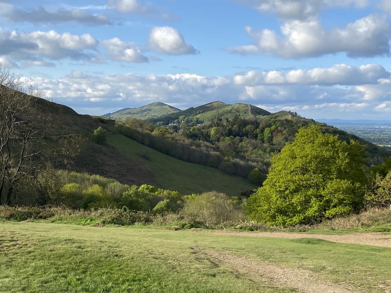
    At a junction of paths we go to the right and make a short steep ascent to reach the top of the ridge.  This is not the last of the uphill walking, but it has taken us to a point where we can see either side of the hills and the clear route in front of us.

    It is our intention to walk along all the summits on this northern section of the ridge and then pick a less strenuous route for our return to the car park.  So we follow the broad path as it heads north towards Black Hill.  To our right we look over the County Showground with all the marquees set up for the flower show.

    After going over Black Hill the next summit looming in front of us is Pinnacle Hill.

    The path we are taking along the ridge follows the route of the Shire Ditch, this forms  the boundary between Herefordshire and Worcestershire.  Apparently in the 13th century, the Earl of Gloucester was granted the hunting rights to the east of the Malvern Hills, but he kept popping over to the west side onto land owned by the Bishop of Herefordshire and was accused of trespass.  After a hearing which the Bishop won, the Earl fortified the shire ditch so that his livestock could not stray to the west.

    Staying with the clear path we go over Jubilee Hill and Perseverance Hill and then start to descend into Upper Wyche.  Here the Wyche Spring Well has also been dressed.

    From the bench besides the well we cross the road to join Beacon Road which heads uphill to pass a car park and then continues upwards as a pathway.

    The path leads us to a stone structure with waymarkers, it shows the location as Gold Mine.  Apparently back in the reign of Elizabeth I small quantities of gold were extracted from these hills though subsequent efforts to strike it rich have proved fruitless.

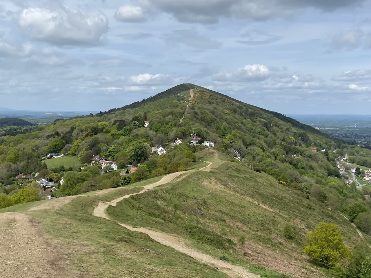
    Now on the ridge we head north over Summer Hill towards the Worcestershire Beacon which has a trig point besides it.  We bagged the trig last November and had been here previously many years ago in our pre caravanning days.  That time we stayed at a quirky bed and breakfast, it was prior to online booking and at a time when we would turn up in a town and drive around looking for somewhere to stay.  We had some great times and stayed in some interesting places the likes of which would not survive in the current world of online reviews for everything.

    The Worcestershire Beacon is the highest point in Worcestershire and it has a toposcope erected in 1897 to celebrate the Golden Jubilee of Queen Victoria’s reign. 

    When we walk up hills I frequently tell Lynnie there will be a cafe on the top, of course this is rarely the case and today is no exception.  However, there was a cafe up here for many years until in burnt down in 1987.  When it came to rebuilding it the Malvern Hills Conservators were refused planning permission and they sought to amend the Malvern Hills Bill which was going through parliamentary process.  After a visit by members of the House of Lords Select Committee it was determined there were enough alternative facilities in the area and there was no need for a cafe.  

    Personally I think a cafe here would detract from the beauty of the location, but of course Lynnie would  argue the provision of ice cream on top of a hill would be an asset, indeed an essential requirement.

    There is an extensive network of paths here so it is difficult to describe with accuracy our route, we are heading to St Ann’s Well via Green Valley.  

    The path we take goes around Sugarloaf Hill and then goes right to descend into Green Valley where we come across another dressed well.

    Now it is just a case of following the waymarkers as the path heads downhill towards St Ann’s Well.

    The water supply at St Ann’s Well is located in a building dating back to 1813 and has a very elaborate carved water Sicilian marble water spout which was donated by the local landowner, Lady Emily Foley, in 1892.

    The water here is said to have special healing qualities and was a very popular source of the pure water flowing from the hills.  The popularity of the site resulted in the addition of an octagonal building in 1841.  

    It is a fine building but in 1963 the Malvern Hills Conservators thought it might be a good idea to demolish the Victorian buildings.  Clearly they forgot the conservation element of their role, thankfully common sense prevailed and the historic building continues to operate as a cafe.  To Lynnie’s delight she is able to acquire an ice cream just before the cafe closes for the day.

    From the cafe we join a path heading south which follows the contour line through trees.

    The path leads us to the edge of a quarry on the eastern side of Summer Hill.

    From the quarry the path gradually ascends to return to the Gold Mine route marker.  From here we return to Upper Wyche on the track we walked earlier.  After crossing the road we take the path at the side of the fine bus shelter besides the public toilets.

    After ascending to the ridge we take a path that skirts around the summit of Perseverance Hill and then I head over Jubilee Hill whilst Lynnie takes a path around the side.

    At Pinnacle Hill we both decide to take the path that goes around rather than over the summit and do the same when we get to Black Hill.  There are plenty of options for our descent, we take a path down towards a car park and then walk alongside the B4232 to return to our starting point in the British Camp car park.

    Our walk has covered almost 9 miles, there has been a lot of ascent and fortunately we have been blessed with a clear day to appreciate the stunning views.

    You can view this 9 mile walk on OS Maps and download the GPX File Here

    To follow my walk, you will need Ordnance Survey Maps: OS Explorer Map – 190 – Malvern Hills & Bredon Hill

    5th May 2022

    © Two Dogs and an Awning (2022)

    All information on this site is provided free of charge and in good faith and no liability is accepted in respect of damage, loss or injury which might result from it.  To the best of my knowledge the routes are entirely on public rights of way or within areas that are open for public access.
    Walking can be hazardous and is done entirely at your own risk.  It is your responsibility to check your route and navigate using a map and compass.

  • A Camp, Cave and Obelisk on the Malvern Hills

    A Camp, Cave and Obelisk on the Malvern Hills

    On our previous trip to Goodleigh Hill CL in November I did a couple of walks on the Malvern Hills.  On the first Lynnie accompanied me, but on the second I visited British Camp on a very cold day with snow forecast and Lynnie declined to join me, preferring to spend a few hours wandering around Pershore.  It was a stunning walk and is top of my list of places to revisit during this stay. 

    It is about fifteen miles from the caravan site to the British Camp car park (WR13 6DW) besides the A449.  This is a pay and display car park with a set fee for the day, the proceeds are used to maintain the Malvern Hills as an area of outstanding natural beauty.  Leaving the car park we go through a gate and follow a broad path that gradually ascends the hill.

    At a junction of paths we continue straight on, ignoring steps which lead to British Camp.  The path we are on hugs the contour line below the camp and soon take us above the British Camp Reservoir.  

    Apparently following water shortages, the 1891 Malvern Water Act was introduced.  This allowed the reservoir to be built and it was opened in 1895, it collects water from the springs in the area.   It is a fine looking small reservoir, the current low level of water reflects the recent dry spell we have been experiencing.

    The path we are on is the route of the Three Choirs Way, a 100-mile long distance walk which links the cathedral towns of Worcester, Hereford and Gloucester.  After passing the reservoir we start to  gradually ascend to a point where a number of paths join.  Here we stay with the route of the Three Choirs Way as it leads past Clutter’s Cave.  According to the Malvern Hills Trust this is a folly created in Edwardian or Victorian times, however, others describe it as a small quarry or a medieval hermit’s dwelling.  Confusingly it is also known as Hermit’s Cave, Giant’s Cave or Waum’s Cave.

    The pat continues along the ridge and then at a junction of paths we stay with the Three Choirs Way as it gradually descends towards Gullet Wood.  There is a stone marker here pointing the way to The Gullet and Midsummer Hill.

    It is a cracking afternoon and we pass an area of bluebells and continue along the path to go through a gate besides a cattle grid.

    We now continue on the track to reach a junction of tracks, we turn right and go through a kissing gate and head uphill on the route of the Geopark Way.  This long-distance path goes 109 miles between Bridgnorth and Gloucester exploring the geological changes along the way.  We are only following for a short distance to reach Eastnor Obelisk at the top of the hill.

    This obelisk was erected in 1812 and is a monument to various members of the Somers Cocks family.  Those commemorated include John Somers, Lord Chancellor in 1700 who was an adviser to William III, and Philip James Cocks, who was an intelligence officer on Wellington’s staff and died during the siege of Burgos in the Peninsular War in 1812. Afterwards his father, Earl Somers, had the obelisk erected.

    From the obelisk we retrace our route down the hill to the junction of paths.

    After going through the gate we continue along the route of the Geopark Way and the Three Choirs Way heading south towards the A438.

    As we head along this track we get a good view back across to the Eastnor Obelisk.

    On reaching the A438 we turn right at the entrance to a small car park and walk along the road for just over a hundred yards and then cross the road with care to go through a kissing gate leading to Ragged Stone Common.  This is open access land but we choose to initially stick to the route of the Geopark Way which goes to the right and skirts around the hill passing through an area of stunning Bluebells.

    When the Geopark Way turns to the right we continue on a clear path leading to Whiteleaved Oak.  In this attractive hamlet we turn right and then almost immediately turn left on a path which goes besides a cottage and continues along a sunken track.

    The track leads to open access land where we continue on a well-worn path that ascends Chase End Hill.  This is a short steep ascent and we are soon on the top of the hill standing beside the Ordnance Survey trig pillar.  I bagged this trig back in November but it is Lynnie’s first visit here.

    It is a cracking day and the views from Chase End Hill are stunning.

    We continue on heading downhill to a junction of paths where we turn left and then left again to follow a track through woodland.

    At a junction paths we turn right to leave the track and briefly go downhill to reach the Three Choirs Way where we turn left and follow what appears to be an old tramway heading north.  We soon cross a bridge over a minor road in Whiteleaved Oak.

    On leaving the woodland the route continues across fields.

    After passing an interesting thatch cottage we join a minor road and follow this towards the A438.

    After passing Hollybush village hall we cross the main road and continue along a minor road.

    This minor road goes north along the edge of woodland and then as we near The Gullett we fork left on a path, the map shows this a minor road, but clearly it is a long time since a vehicle travelled along it.

    This path goes above a stream and then on reaching a bridge over the water we turn right to cross the bridge and then turn right again to follow a path alongside the disused Gullet Quarry.  In the early 1900’s many quarries were opened on the Malvern Hills to extract granite for road making.  In 1953 the government of the day decided that extraction should stop and most of the quarries closed, but an exception was made for this quarry and it continued to be worked for another twenty years before closing around 1977.

    There are numerous signs about the dangers of wild swimming and every effort has been made to make the quarry inaccessible, however, people foolishly continue to try and access the water to swim.  Sadly there are numerous reports of deaths, mainly of young men.  In 2020 the Herefordshire and Worcestershire Fire and Rescue service told the BBC that there had been 5 deaths in the previous 14 years.  

    The information board besides the quarry explains the geological structure of the hills.  We walk along a track and then as it nears a road turn left to head steadily up Swinyard Hill.  

    One of the features about walking around the Malvern Hills is the old waymarkers that indicate various routes.  We reach one of these and take the route to Giant’s Cave and British Camp.

    This is the path we walked down earlier as we descended from the cave and it soon comes into view again.

    Continuing on past the cave we reach a point where there are multiple options, we take the route towards British Camp.

    The route goes uphill giving good views back across the British Camp Reservoir.

    I visited British Camp last November for the first time, on that occasion Lynnie was not with me so it is her first visit and it could not be a better evening for it.

    British Camp was originally an Iron Age hillfort and thought to be bonded around the time of the Roman invasion.  It was later the location of a medieval castle which was constructed within the iron age ramparts.

    The summit of the hill is known as Herefordshire Beacon, this is not the highest point of Herefordshire, but it still stands at 338 metres, or if you prefer 1,109 feet, above sea level and on a day like this the views are panoramic.

    In front the northern ridge of the hills stretch into the distance, we plan to walk along that ridge tomorrow and the number of ascents and descents look a bit daunting from here.

    We have one last descent on our walk today making our way down the hill back to our starting point in the British Camp car park.  It has been a cracking walk covering nine miles, which is shorter than I would normally walk, but there has been 1,555 feet of ascent along the way so not a bad day’s exercise.

    You can view this 9 mile walk on OS Maps and download the GPX File Here

    To follow my walk, you will need Ordnance Survey Maps: OS Explorer Map – 190 – Malvern Hills & Bredon Hill

    4th May 2022

    © Two Dogs and an Awning (2022)

    All information on this site is provided free of charge and in good faith and no liability is accepted in respect of damage, loss or injury which might result from it.  To the best of my knowledge the routes are entirely on public rights of way or within areas that are open for public access.
    Walking can be hazardous and is done entirely at your own risk.  It is your responsibility to check your route and navigate using a map and compass.