The weather last night was rough, no rain, but the wind associated with storm Hector was particularly strong and as a consequence I had a very disturbed night frequently checking that the awning was secure. A few years ago we moved to using an air awning and it has proved a good decision, in high winds it is very flexible with no risk of a stray pole damaging the caravan.
(more…)
Category: Derbyshire
-

A Seven Mile Circuit from Ogston Reservoir
-

A Trig Point, Steam Train and Ice Cream on a walk from Tax Farm CL
Checking the local maps last night I planned a walk for today that would include an opportunity to bag a trig point. I also noticed there was another trig nearby in the woods on Farley Moor that I could bag on my morning walk with the dogs. (more…)
-

Arriving at Tax Farm CL
After a month in Yorkshire it is time for us to head south. We have decided to break the journey home with a stay in the Peak District, close to Matlock. This is an area we visited, briefly, several years ago and it will be an opportunity to explore new ground. A few hours after leaving Brigholme Farm CL we are pitching up on Tax Farm CL.
(more…) -
A Night at Poolsbrook Country Park
After five weeks at home we are on the road again and heading north towards Yorkshire so we can combine some walking with a bit of work. We decide to break the journey with a one-night stopover just off the M1 near Chesterfield.
Our pitch is on the Caravan Club’s main site at Poolsbrook Country Park. Blog followers will know we do not usually stay on big sites, but this one is ideal. It is only a mile or two from Junction 29A on the M1. It does not sound the most salubrious of locations but will do us for a night.
(more…) -

Ice Cream for Lynnie
As previously mentioned Lynnie and I have visited the Peak District in the past and done a number of walks from our walking books of the area. The problem is we can’t recall which ones so we are undecided if we have done a walk from Bakewell or not. Lynnie says we have but I am not so sure.
There is only one way to find out, so we drive to Bakewell and park in the town alongside the show ground, it is being prepared for the forthcoming Bakewell show. This bit is familiar, but I know we have visited Bakewell in the past.
(more…) -

Lime Kilns
We decide it is a day to walk from the site. Blackwell Hall CL has a footpath running alongside it leading down to the Monsal Trail. So late afternoon we set off with the boys on this route.
From the site we go through Blackwell Hall farmyard, along the track, through a couple of gates and a field of young bears before descending steeply, beneath us is the long Chee Tor tunnel. At a junction of paths we turn right soon joining the Monsal Trail not far from the tunnel entrance.
(more…) -

Big Stones
A sunny Sunday finds us in Matlock. Lynnie has identified a walk of around nine miles that fits her criteria of a suitable stroll. We park up alongside Hall Leys Park. This is another one of those cracking Victorian public parks. It opened in 1898 and was refurbished in 2004/05 and is very busy on this sunny day.
(more…) -

Jitty, Jinnell or Twichell?
On previous visits to the Peak District we have not been to Tideswell, so today we head there to start our walk. Apparently Tideswell is the second largest town in the Peak District National Park, with Bakewell the largest. Both Buxton and Matlock are bigger but sit outside of the Park boundary.
(more…) -

Hey Diddle Diddle
We wake to a bright sunny day on our new site. Yesterday we made the trip from Lancaster to Taddington in the Peak District. As moving days go it was straightforward and the journey took a couple of hours, ideal as the weather was hot.
We have had a great stay on Heron’s Wood CL, it has been warm (often hot) and sunny all week. It is interesting how the attitude of caravanners staying on a site appears to reflect the approach of the site owners. The site owner Cath is warm and welcoming to all her guests and those staying on the site have been very chatty.
After pitching up yesterday we went for our usual wander to get our bearings. It is a number of years since we were in the Peak District and had forgotten how dramatic the scenery is.
Our walk today starts at the Cat and Fiddle pub on the A537 between Buxton and Macclesfield. We park in the lay-by opposite the pub, cross the busy road and walk towards Macclesfield for a few hundred yards, at a sharp bend we head over the moor, ignoring footpaths to the left and right and walk towards Errwood Reservoir.
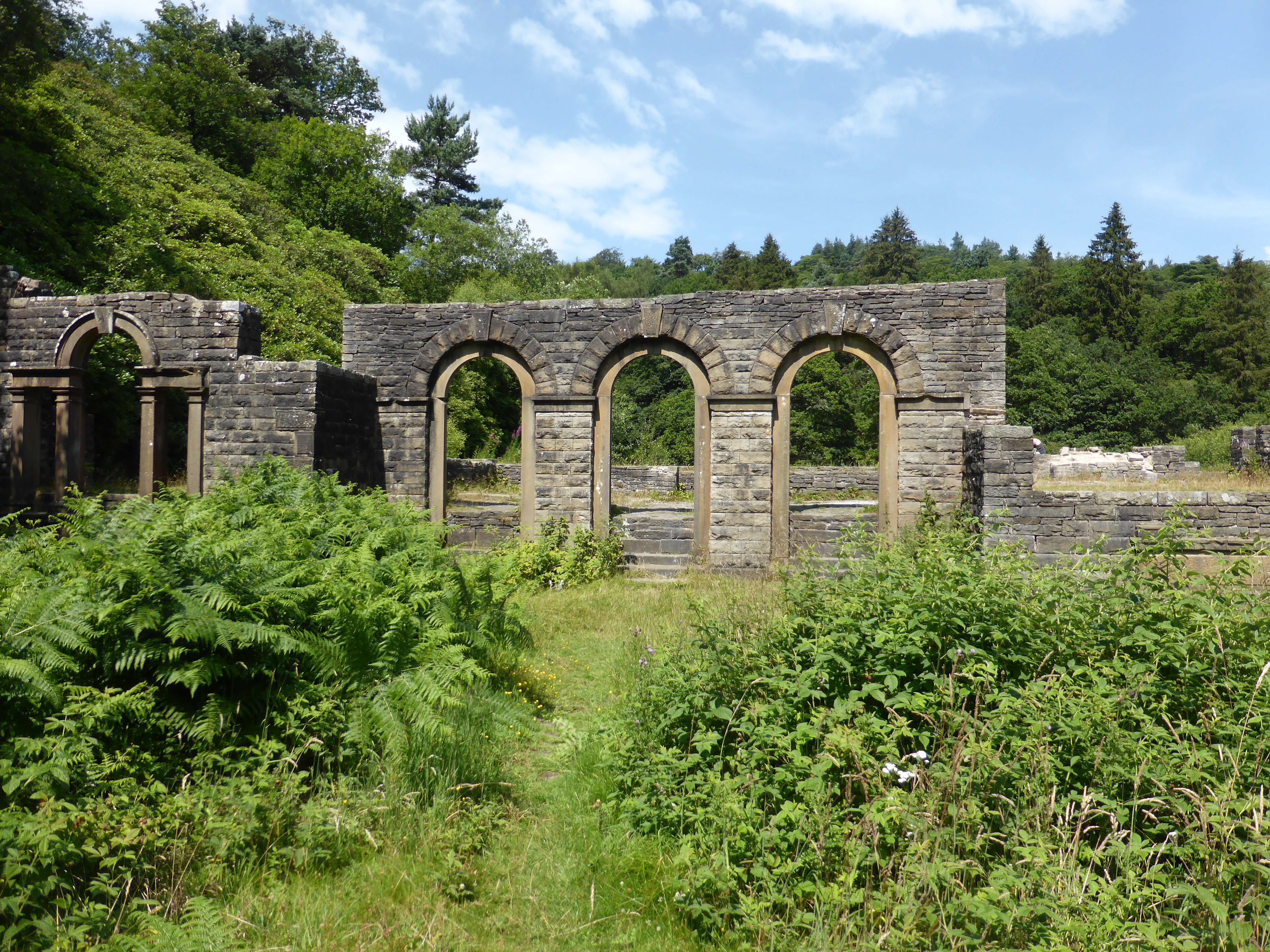
At the bottom of the hill with the reservoir in front of us we turn left and take a walk up to Errwood Hall. This once splendid building now lies in ruins. It was built in the 1830’s for Samuel Grimshawe a wealthy businessman from Manchester. The Grimshawe family lived here for over 100 years and the Hall was at the centre of a 2,000-acre estate, which included the Cat and Fiddle Inn, a coalmine and a hamlet at Goyt’s Bridge.
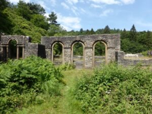
The hall lasted as a residence for 100 years but was demolished at the time that nearby Fernilee Reservoir was built in 1934. Stones from the demolished Hall were used to build the water treatment works at the reservoir. After visiting the Hall we walk down to Errwood Reservoir, built in 1967, and providing drinking water for Stockport. When full the reservoir holds 4,215 million litres of water. Today there is a lot less than that in the reservoir with large sections of the bank exposed.
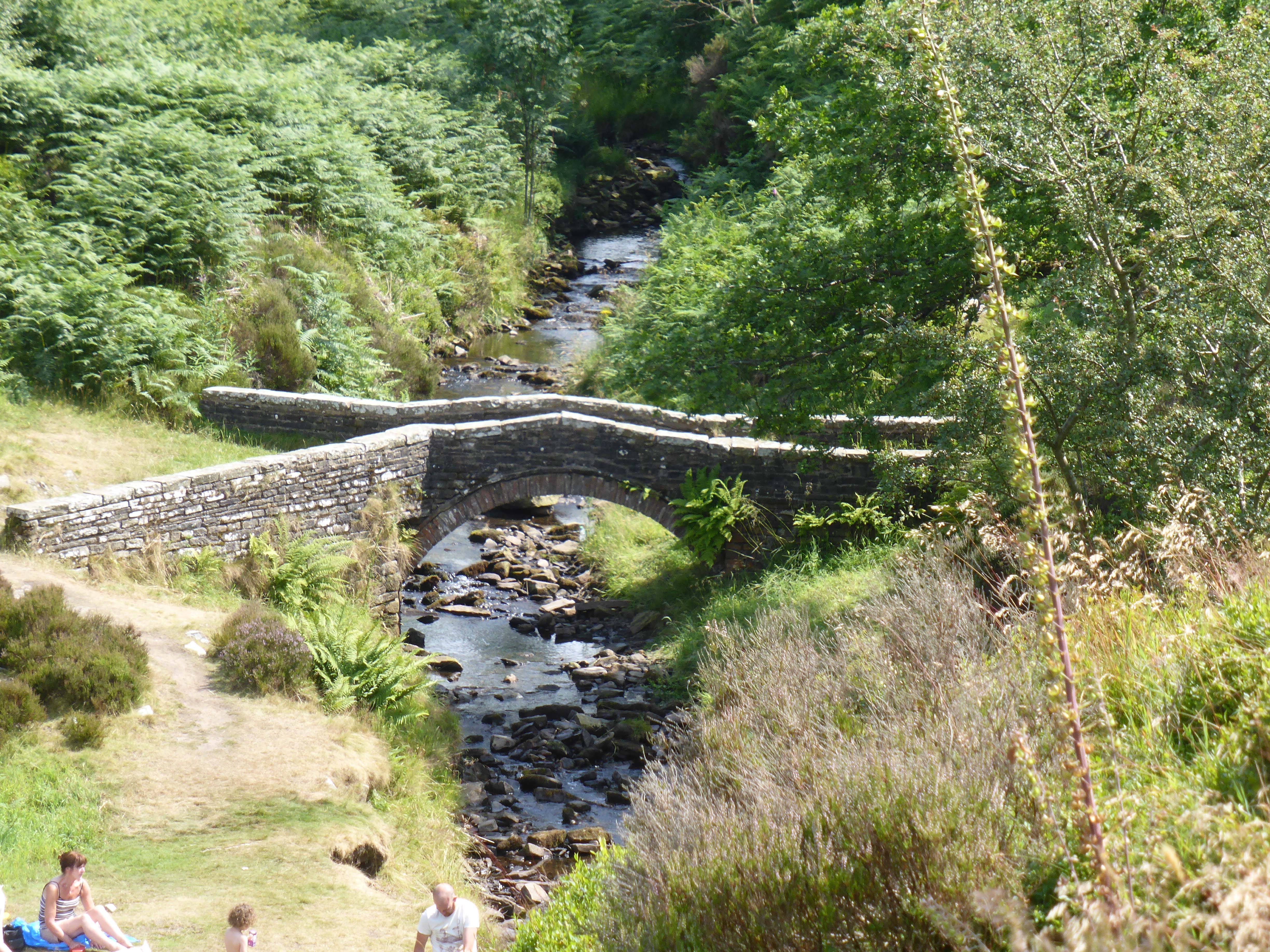
We walk up the Goyt Valley on the quiet road that leads to Derbyshire Bridge. It is hard to believe that this valley was once the main transport route between London and Manchester. As we progress up the valley, above the river, we see packhorse bridges below us.

It was in the Goyt Valley at Goyt’s Clough Quarry that in 18th Century Thomas Pickford set up a family business mending roads. The business expanded and his son James Pickford was known as the London to Manchester Waggoner. The business still thrives today as Pickford’s Removals.
At the car park at the top of the valley we take a track on our left and after a couple of hundred yards cross a stile to enter a moorland field. In parts it’s a bit boggy, but we stick closely to the path as signs warn of disused mine shafts in the area.
We soon emerge onto a track and are greeted by the distinctive call of a Grouse. In a couple of weeks time he will have to be wary, but still has a short while to enjoy the summer before wealthy visitors start firing lead shot at him.
We follow the track and turn right for a short distance across the moor to meet the A54. We cross the road and there is good view back down the valley and up to the Cat and Fiddle. It would take us about twenty minutes to walk back to the car from here, but there is still another couple of hours to our route.
We walk across the moor to Cheeks Hill passing disused mine shafts. Across a lane and back onto the moor to climb a wall stile at some old stone sheep pens, before heading down a footpath joining a bridleway towards Orchard Farm. Here we briefly deviate from the route in our walking book, but soon find that a field of young bears blocks our short cut. Instead we head back towards Orchard Farm and pickup the footpath. It is very hot now and I hear the first signs of grumbling from Lynnie.
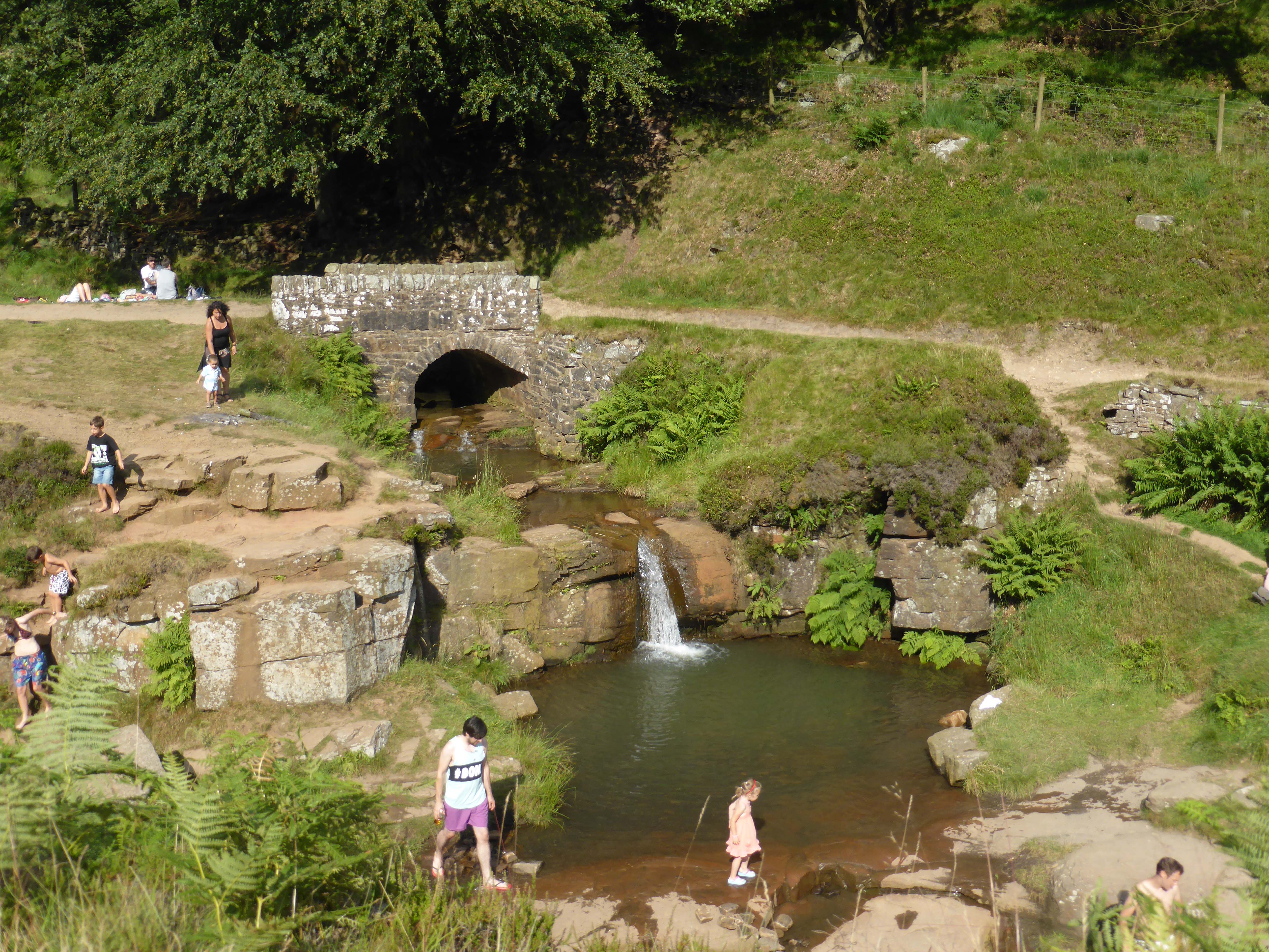
We are soon on a footpath alongside the beck that flows down towards Three Shires Head. This is an attractive walk over slightly rough terrain, we pass a packhorse bridge half way down and at Three Shires Head there are loads of families playing in and around the river. It is a lovely spot and very hot and sunny.
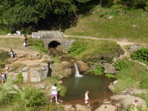
It is said that Three Shires Head was a favourite location for Cock fighting. The proximity to the county boundaries of Derbyshire, Staffordshire and Cheshire meant that when the local constabulary arrived those organizing the fights could hop over the boundary and avoid arrest. At this point four packhorse routes meet and the joining of the rivers and the waterfalls make it a pretty spot. Under one waterfall is a small plunge pool, Panniers Pool, which is popular with both young and old.
We cross the River Dane and then turn right to follow it for a mile or so. Lynnie’s grumble is turning into a whinge. When the children were small we did a lot of walking with them. Lolly was capable but not always keen and there was a need to find something interesting along the way to set as a target. A stile was a favourite, to see if she could get there before her brother.
When Lolly was starting to falter on walks she would drop back and we would hear the familiar sound of “I can’t walk any further” and her bottom lip would start to protrude. As we turn the corner and see the steep climb to the old lead mine chimney Lynnie is starting to sound like Lolly. She tells me she is unable to walk another step. With Lolly the promise of an ice cream or visit to a pub at the end of a walk was usually enough to motivate her. I try this trick with Lynnie. It has limited success!
We continue up the very steep path. I go ahead on the pretext of ensuring that the route is safe, but really trying to get far enough away so I can’t hear Lynnie’s moans!
We reach the busy A54 and negotiate a difficult stile by the road before crossing and joining the broad path on the opposite side. This takes us back to the Cat and Fiddle, along the way we are treated to some panoramic views. As the pub comes into view Lynnie’s pace quickens and the moaning ceases. It shows that I need to start planning walks with pubs and ice cream stops at regular intervals.
Our walking book says that the walk was eleven miles, but with the various diversions we have walked nearer to fourteen. It has been a cracking afternoon, (despite Lynnie’s whinges). It only seems right to pop into the Cat and Fiddle for a pint of Robinson’s Ale. Robinsons is still a family run brewery based in Stockport and founded in 1836. I opt for a pint of Copper Dragon and it is top class. What I would call a cracking pint of ale, ‘good old fashioned beer with lots of foam’.
The Cat and Fiddle is the second highest pub in England standing at 1,689 feet above sea level. It occupies a remote spot on the moor and must be quiet on a stormy winters night. The highest pub in England is the Tan Hill Inn situated in the Yorkshire Dales north of Keld. Followers of this blog will recall that we were walking through Keld about six weeks ago. The Tan Hill Inn stands 1,732 feet above sea level.
To follow our walk you will need Ordnance Survey Map Outdoor Leisure Map 24 – The Peak District – White Peak Area]
25th July 2014
© Two Dogs and an Awning (2014)